Remote sensing estimation method of biological bearing capacity

A carrying capacity and ecological technology, applied in the field of remote sensing estimation of ecological carrying capacity, can solve problems such as no calculation of point source pollution impact, large regional differences, and difficulty in obtaining basic ground data

Active Publication Date: 2015-04-15
INST OF REMOTE SENSING & DIGITAL EARTH CHINESE ACADEMY OF SCI
View PDF2 Cites 21 Cited by
  • Summary
  • Abstract
  • Description
  • Claims
  • Application Information

AI Technical Summary

Problems solved by technology

First of all, my country is a large agricultural country with a large population and complex underlying surface conditions. It is difficult to use the single factor carrying capacity to study the requirements for the development and development of ecosystem resources. Second, my country has a vast territory and large regional differences. When calculating the ecological carrying capacity, it is very difficult to obtain basic ground data; thirdly, the pollution discharge intensity is an important indicator for evaluating

Method used


Image

  • Remote sensing estimation method of biological bearing capacity
  • Remote sensing estimation method of biological bearing capacity
  • Remote sensing estimation method of biological bearing capacity

Examples


Embodiment Construction

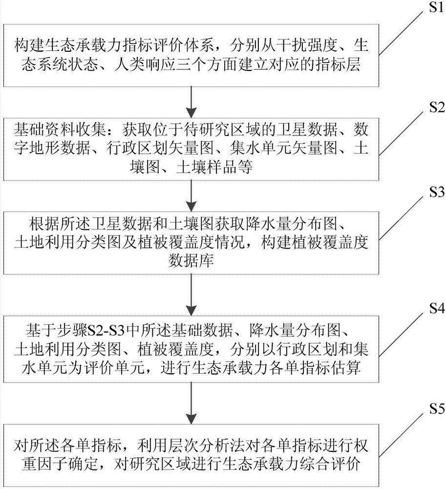
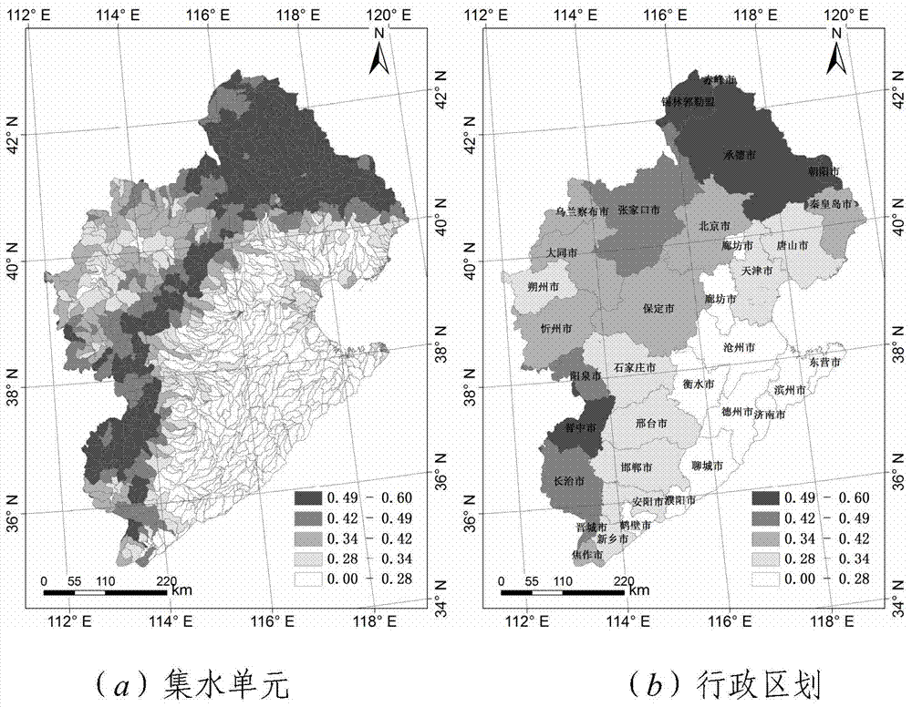
[0040] The specific implementation manners of the present invention will be further described in detail below in conjunction with the accompanying drawings and embodiments. The following examples are used to illustrate the present invention, but are not intended to limit the scope of the present invention.

[0041] Moderate Resolution Imaging Spectroradiometer MODIS (Moderate Resolution Imaging Spectroradiometer) data is widely used in long-term global observations of the Earth's surface, biosphere, atmosphere, and ocean due to its wide spectral range, short return period, and easy acquisition. MODIS data products have mature algorithms and various types, and have become an important data source for the daily business of many departments. The satellite used for the fine classification of land cover mentioned in the present invention is preferably MODIS, and the satellite remote sensing data especially refers to MODIS product data. Tropical Rainfall Measuring Mission satellite...


PUM


Abstract

The invention relates to a remote sensing estimation method of a biological bearing capacity. The remote sensing estimation method comprises the following steps: constructing a biological bearing capacity index evaluation system; establishing corresponding index layers from three aspects including jamming intensity, a biological system state and human responding respectively; collecting basic information; constructing a vegetation coverage database; taking administrative division and a water collection unit as evaluation units respectively based on basic data, a soil utilization classification chart and vegetation coverage; and carrying out biological bearing capacity single-index estimation. Each single index is subjected to weight factor determination by using an analytic hierarchy process, and biological bearing capacity comprehensive evaluation is carried out. A quantitative remote sensing coupling concept is utilized and space isomerism is considered; a region difference of a region to be estimated is represented; the biological bearing capacity index evaluation system is constructed so that digitalization of a compound biological system is realized; the biological bearing capacity evaluation of the region to be estimated can be rapidly and comprehensively realized.

Description

technical field [0001] The invention relates to the technical field of ecological protection, and relates to an estimation method of ecological environment carrying capacity, in particular to a remote sensing estimation method of ecological carrying capacity. Background technique [0002] Since the 20th century, with the advancement of science and technology and the great improvement of social productivity, problems such as population growth, excessive consumption of resources, environmental pollution, and ecological damage have become increasingly prominent, resulting in the decline of ecological carrying capacity in many areas and threatening the future survival of human beings. [0003] Maintaining the integrity of the ecosystem and controlling human activities within the carrying capacity of the ecosystem are the most basic and primary conditions for realizing the sustainable development of the ecosystem and the region. Most of the relevant research on ecological carryin...

Claims


Application Information

Patent Timeline
IPC IPC(8): G06F19/00
Inventor 张霞王树东张立福冯淑娜孙艳丽
Owner INST OF REMOTE SENSING & DIGITAL EARTH CHINESE ACADEMY OF SCI
Why Eureka
Try Eureka