Intelligent driving assistance system

An auxiliary system and intelligent driving technology, which is applied to vehicle components, vehicle safety arrangements, pedestrian/passenger safety arrangements, etc., can solve problems such as inaccurate navigation and positioning, inaccurate positioning data, and positioning blind spots, so as to ensure safe and accurate driving Regional navigation, the effect of making up for blind spots

Active Publication Date: 2015-04-29
DEEPBLUE TECH (SHANGHAI) CO LTD
View PDF7 Cites 4 Cited by
  • Summary
  • Abstract
  • Description
  • Claims
  • Application Information

AI Technical Summary

Problems solved by technology

[0003] However, in the prior art, no matter whether the GPS unit or the Beidou positioning and navigation unit is used, the GPS signal fading is very large or the GPS signal cannot be received, the function of positioning and navigation will not be realized; when the number of receiving GPS is small, It will also lead to inaccurate positioning data, and there are problems such as random deviations, that is, in the prior art, there is a problem of positioning blind spots in both positioning and navigation systems that use GPS units or Beidou positioning and navigation units.
[0004] With the wide application of gyroscopes, in order to solve the problem of positioning blind spots in existing positioning and navigation systems, various vehicle positioning monitoring and navigation systems based on gyroscope inertial navigation, or GPS / Beidou and gyroscope integrated navigation have emerged one after another. However, In the prior art, the system implementation cost of the above solution is relatively high, and the error is also relatively large, resulting in inaccurate navigation and positioning
[0005] In addition, in order to reduce safety accidents, the existing car navigation system generally installs a distance measuring unit to give an alarm when the distance between the vehicle and the obstacle is less than the safe distance, but the current detection method is single, and the environment changes are more obvious. The distance measuring device using the above technology also has monitoring blind spots, so that there will be system omissions or false alarms, and the stability is poor
[0006] Secondly, the existing car navigation systems generally use standard simplified map models for route navigation, but for complex road conditions, such as overlapping overpasses and multiple intersections, it is difficult to distinguish with the current positioning accuracy, so it is possible lead to navigation error

Method used


Image

  • Intelligent driving assistance system
  • Intelligent driving assistance system
  • Intelligent driving assistance system

Examples


Embodiment Construction

[0044] Exemplary embodiments of the present disclosure will be described in more detail below with reference to the accompanying drawings. Although exemplary embodiments of the present disclosure are shown in the drawings, it should be understood that the present disclosure may be embodied in various forms and should not be limited by the embodiments set forth herein. Rather, these embodiments are provided for more thorough understanding of the present disclosure and to fully convey the scope of the present disclosure to those skilled in the art.

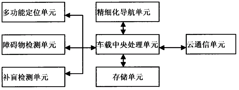
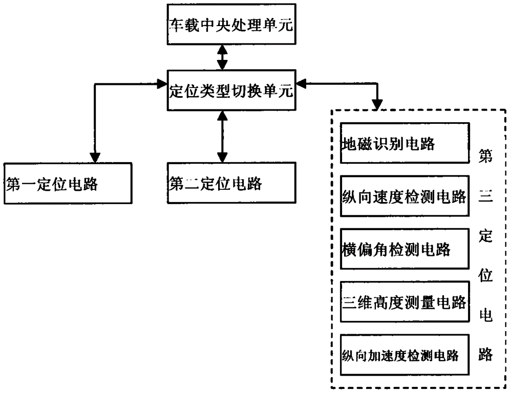
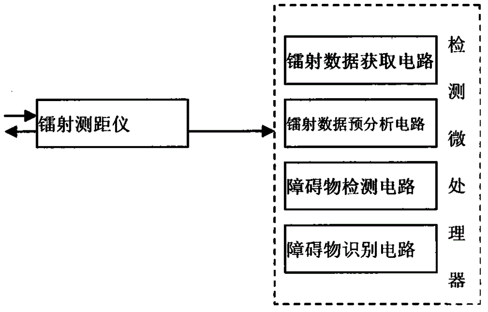
[0045] According to the embodiment of the present invention, an intelligent driving assistance system is proposed, as attached figure 1 As shown, the system includes a multifunctional positioning unit, an obstacle detection unit, a blind complement detection unit, a refined navigation unit, a vehicle-mounted central processing unit, a storage unit, and a cloud communication unit, wherein,

[0046] The multi-functional positioning u...


PUM


Abstract

The invention provides an intelligent driving assistance system. The intelligent driving assistance system comprises a multifunctional positioning unit, a barrier detection unit, a blind compensation unit, a fining navigation unit, a vehicle-mounted CPU (Central Processing Unit), a storage unit and a cloud communication unit. According to the intelligent driving assistance system provided by the invention, a blind area of GPS (Global Positioning System) navigation can be effectively remedied, and the demands on positioning navigation under various environments are realized through various positioning forms; in addition, the driving safety is more comprehensively ensured through barrier laser detection and blind compensation detection, and accurate area navigation is realized through fining navigation operation.

Description

technical field [0001] The invention relates to the field of intelligent transportation, in particular to an intelligent driving assistance system. Background technique [0002] As an important part of a smart city, smart transportation is getting more and more attention. Taking the driving assistance system as an example, the core components of today's car positioning monitoring and navigation systems usually include: positioning unit (using GPS unit or Beidou positioning unit), data communication unit (using GPRS or 3G) and data processing unit and system platform. Moreover, the positioning unit is indispensable in almost all vehicle positioning monitoring and navigation systems at present. Location units are the most basic source of location data. [0003] However, in the prior art, no matter whether the GPS unit or the Beidou positioning and navigation unit is used, the GPS signal fading is very large or the GPS signal cannot be received, the function of positioning a...

Claims


Application Information

Patent Timeline
Patent Type & Authority Applications(China)
IPC IPC(8): B60R16/02
CPCB60R16/023B60R21/013
Inventor 朱今兰
Owner DEEPBLUE TECH (SHANGHAI) CO LTD
Why Eureka
Try Eureka