Geographical physical characterization method for channel sand reservoir type oil and gas gathering conditions
A geophysical and sand oil technology, applied in the field of petroleum exploration, can solve the problems of only focusing on the detection of oil content of sand bodies, lack of vector characterization of structural ridges, and low identification accuracy of small faults.
- Summary
- Abstract
- Description
- Claims
- Application Information
AI Technical Summary
Problems solved by technology
Method used
Image
Examples
Embodiment Construction
[0027] In order to make the above and other objects, features and advantages of the present invention more comprehensible, preferred embodiments are listed below and described in detail in conjunction with the accompanying drawings.
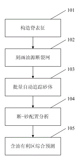
[0028] Such as figure 1 as shown, figure 1 It is a flow chart of the geophysical characterization method for channel sand oil reservoir type oil and gas accumulation conditions of the present invention.
[0029] In step 101, a ridge representation is constructed.
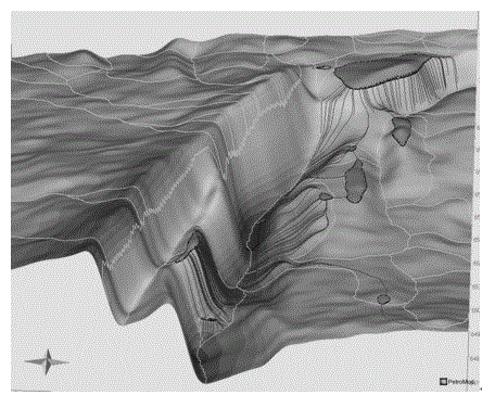
[0030] Based on the principle of fluid potential, the structural gradient vector graphic representation technology is developed to reflect the fluctuations of the structure and intuitively indicate the position of the structural ridges that change spatially.
[0031] Firstly, the layers are finely interpreted, and the gradient attributes are calculated through the time-depth conversion to the depth domain. At the same time, according to the source rock development interval and locat...
PUM
 Abstract
Description
Claims
Application Information
 - R&D
- Intellectual Property
- Life Sciences
- Materials
- Tech Scout
- Unparalleled Data Quality
- Higher Quality Content
- 60% Fewer Hallucinations
Browse by: Latest US Patents, China's latest patents, Technical Efficacy Thesaurus, Application Domain, Technology Topic, Popular Technical Reports.
© 2025 PatSnap. All rights reserved.Legal|Privacy policy|Modern Slavery Act Transparency Statement|Sitemap|About US| Contact US: help@patsnap.com


