
A Zenith Tropospheric Delay Modeling Method for Sparse Reference Station Network Considering Elevation Difference

A zenith troposphere and reference station technology, applied in satellite radio beacon positioning systems, measuring devices, instruments, etc., can solve problems such as poor applicability

Active Publication Date: 2017-05-10
SOUTHEAST UNIV
View PDF3 Cites 0 Cited by
  • Summary
  • Abstract
  • Description
  • Claims
  • Application Information

AI Technical Summary

Problems solved by technology

In the field of PPP, the current regionally enhanced PPP zenith tropospheric error modeling methods are mostly based on the Regional Continuous Operational Reference System (CORS), which has certain requirements for the number and spatial distance of reference stations, and relies on sparse reference for remote areas. Poor regional applicability of station enhancements

Method used


Image

  • A Zenith Tropospheric Delay Modeling Method for Sparse Reference Station Network Considering Elevation Difference
  • A Zenith Tropospheric Delay Modeling Method for Sparse Reference Station Network Considering Elevation Difference
  • A Zenith Tropospheric Delay Modeling Method for Sparse Reference Station Network Considering Elevation Difference

Examples


Embodiment Construction

[0060] The present invention will be further explained below in conjunction with the accompanying drawings.

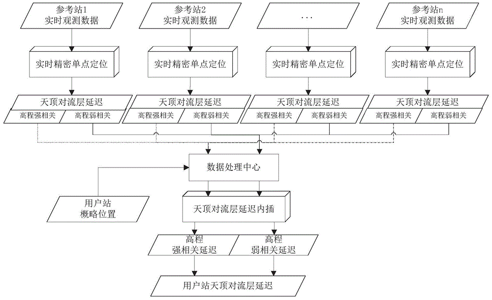
[0061] Such as figure 1 As shown, a sparse reference station network zenith tropospheric delay modeling method that takes into account elevation differences includes the following steps:

[0062] (1), based on the original dual-frequency observations of regional reference stations, using the precise coordinates of each reference station in the region, the zenith tropospheric wet delay value ZWD of each reference station is obtained through ionosphere-free combination precision single-point filtering r , and obtain the zenith tropospheric dry delay value ZHD of each reference station through the tropospheric zenith delay model UNB3m r , where r=1, 2,...., n is the serial number of the reference station, and n is the total number of reference stations; the specific steps are:

[0063] Step (11), establishing the precise point positioning estimation equation based on t...


PUM


Abstract

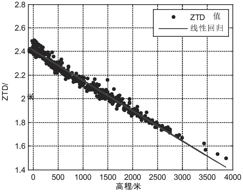
The invention discloses a sparse reference station network zenith troposphere delay modeling method considering the elevation difference. Conventional local area network enhancement PPP (precise point position) modeling methods do not consider effects caused by the elevation difference on the interpolation accuracy and depend on a certain amount of reference stations. According to the method, the relation between the elevation difference and zenith troposphere delay is considered, reference station zenith troposphere wet delay values are calculated through non-ionosphere combined precise point filtering, zenith troposphere dry delay values are calculated through a model, the dry (wet) delay values are divided into an elevation strong correlation part and an elevation weak correlation part according to the relation between the troposphere delay values and elevation factors, and the sparse reference station network zenith troposphere delay modeling method considering the elevation difference is provided on the basis. The method considers the effects caused by the elevation difference on the troposphere delay values, is applicable to sparse reference station local area networks and is low in dependence on the number of the reference stations.

Description

technical field [0001] The invention relates to the field of positioning and monitoring, in particular to a zenith tropospheric delay modeling method for a sparse reference station network that takes into account elevation differences, and is the basis for the research on high-precision and fast positioning of regional reference stations enhanced PPP (Precise Point Position) important part. Background technique [0002] With the perfection and development of the satellite positioning system, the accuracy and reliability of the positioning and monitoring targets are getting higher and higher. In high-precision positioning and navigation calculations, the relative positioning method is usually used, but when the distance between the rover stations is long, the differential positioning method is affected by errors and cannot quickly and accurately obtain precise positioning results. Therefore, for large-scale operations, in order to improve positioning, increasing the number o...

Claims


Application Information

Patent Timeline
Patent Type & Authority Patents(China)
IPC IPC(8): G01S19/37
CPCG01S19/37G16Z99/00
Inventor 喻国荣杨徉潘树国高旺陈伟荣汪登辉
Owner SOUTHEAST UNIV
Learn More