Sparse reference station network zenith troposphere delay modeling method considering elevation difference
A zenith troposphere and delay modeling technology, applied in special data processing applications, satellite radio beacon positioning systems, measurement devices, etc., can solve problems such as poor applicability
- Summary
- Abstract
- Description
- Claims
- Application Information
AI Technical Summary
Problems solved by technology
Method used
Image
Examples
Embodiment Construction
[0060] The present invention will be further explained below in conjunction with the accompanying drawings.
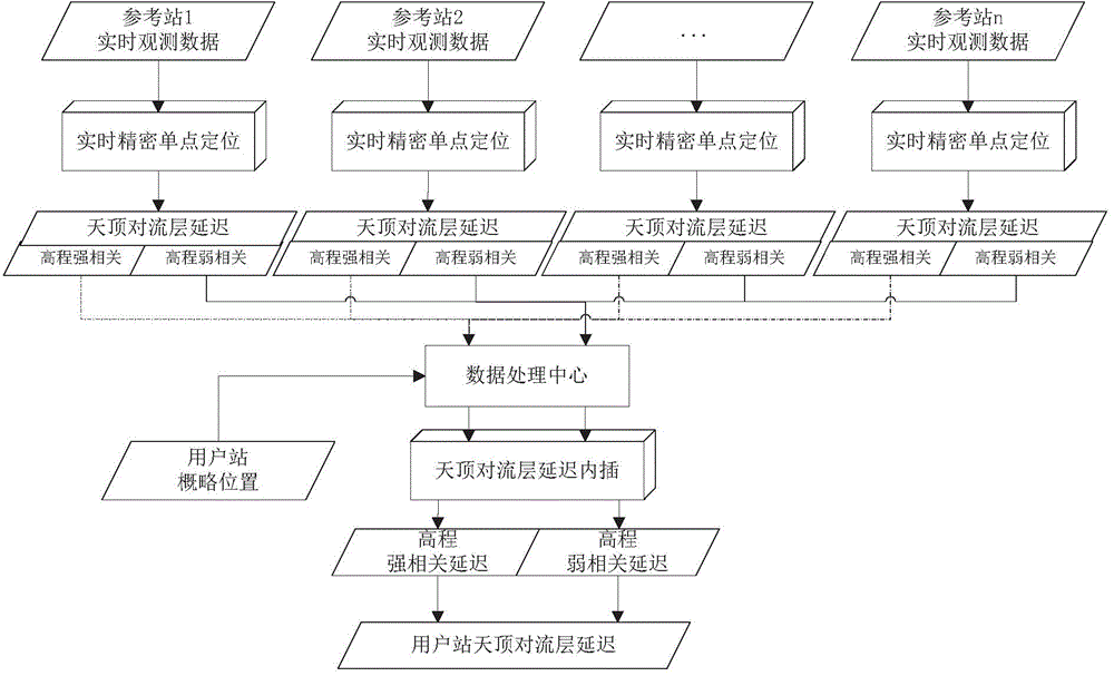
[0061] Such as figure 1 As shown, a sparse reference station network zenith tropospheric delay modeling method that takes into account elevation differences includes the following steps:
[0062] (1), based on the original dual-frequency observations of regional reference stations, using the precise coordinates of each reference station in the region, the zenith tropospheric wet delay value ZWD of each reference station is obtained through ionosphere-free combination precision single-point filtering r , and obtain the zenith tropospheric dry delay value ZHD of each reference station through the tropospheric zenith delay model UNB3m r , where r=1, 2,...., n is the serial number of the reference station, and n is the total number of reference stations; the specific steps are:
[0063] Step (11), establishing the precise point positioning estimation equation based on t...
PUM
 Abstract
Description
Claims
Application Information
 - R&D
- Intellectual Property
- Life Sciences
- Materials
- Tech Scout
- Unparalleled Data Quality
- Higher Quality Content
- 60% Fewer Hallucinations
Browse by: Latest US Patents, China's latest patents, Technical Efficacy Thesaurus, Application Domain, Technology Topic, Popular Technical Reports.
© 2025 PatSnap. All rights reserved.Legal|Privacy policy|Modern Slavery Act Transparency Statement|Sitemap|About US| Contact US: help@patsnap.com


