
A superimposition method of holographic location map

A holographic location map and superposition technology, which is applied in the fields of geographic information and location service technology, can solve problems such as superposition of non-holographic location maps, and achieve the effect of ensuring consistency

Inactive Publication Date: 2017-06-09
WUHAN UNIV
View PDF2 Cites 0 Cited by
  • Summary
  • Abstract
  • Description
  • Claims
  • Application Information

AI Technical Summary

Problems solved by technology

[0006] At present, there are no related patents and documents on the method of superimposing the data of the holographic location map

Method used


Image

  • A superimposition method of holographic location map
  • A superimposition method of holographic location map
  • A superimposition method of holographic location map

Examples


Embodiment Construction

[0027] In order to facilitate those of ordinary skill in the art to understand and implement the present invention, the present invention will be described in further detail below in conjunction with the accompanying drawings and embodiments. It should be understood that the implementation examples described here are only used to illustrate and explain the present invention, and are not intended to limit this invention.

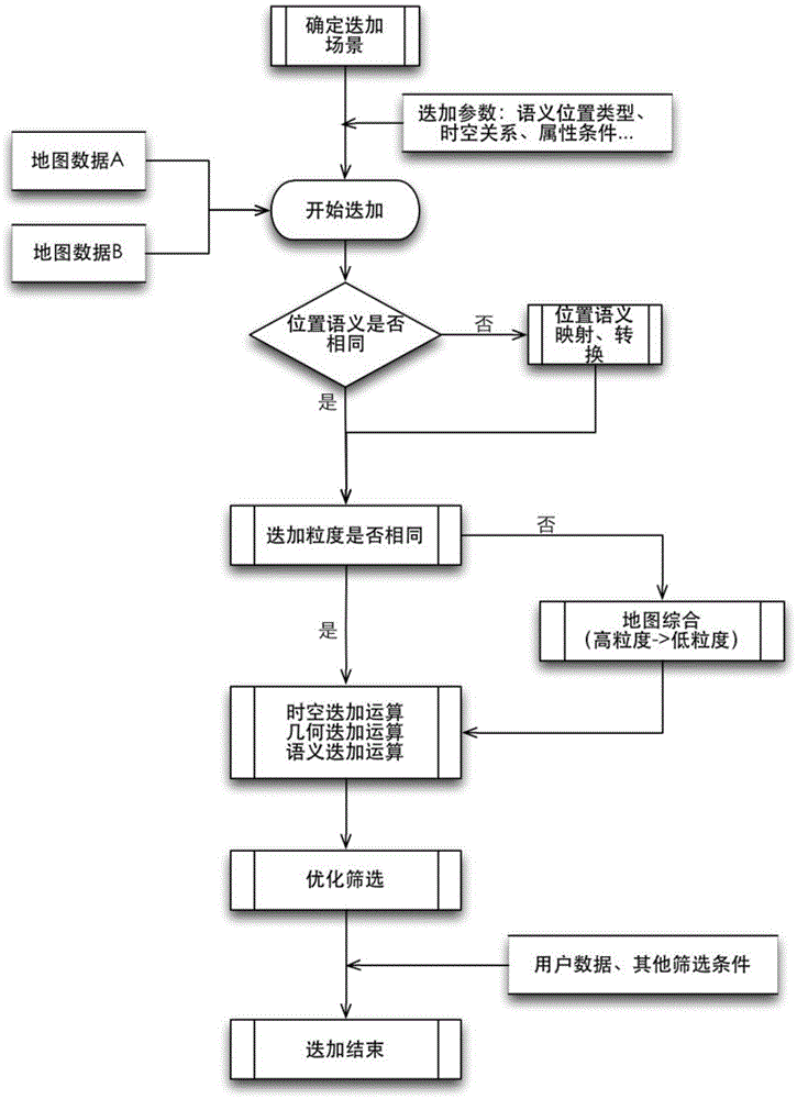
[0028] please see figure 1 , a method for superimposing a holographic position map provided by the present invention, comprising the following steps:

[0029] Step 1: Determine the superposition scenario according to the user's needs, and filter out the superimposed data content, that is, establish a specific scenario according to the user's location, and establish a scenario model, so as to determine which types of map data need to be superimposed under different scenarios;

[0030] Step 2: Judging the semantic position of the map data participating in the ...


PUM


Abstract

The invention discloses a holographic position map superposing method. The holographic position map superposing method comprises superposing procedures and rules of holographic position maps and superposing parameters defined according to the rules and specific modes of the superposing results. On the basis of the rules, multi-source heterogeneous data can provide Internet map data superposing services. For multi-source heterogeneous dynamic information, the superposed holographic position map data can provide data results for the knowledge level by means of the uniform and flexible superposing rules, and the data results can be consistent with users' needs.

Description

technical field [0001] The invention belongs to the field of location service technology and geographic information technology, and relates to a method for superimposing a holographic location map. Background technique [0002] The holographic location map is a digital map based on the location, which fully reflects the location itself and various characteristics, events or things related to the location. It is a new type of map product developed in the map family to meet the development needs of the contemporary location service industry. . The content of the holographic location map includes but is not limited to: two-dimensional vector map data, three-dimensional map data, panoramic data, navigation data, tile map data, indoor map data and multimedia data, dynamic data such as weather and flights, etc. Compared with general location maps, holographic location maps have the following two basic features: [0003] (1) The holographic location map is a collection of four-di...

Claims


Application Information

Patent Timeline
Patent Type & Authority Patents(China)
IPC IPC(8): G06F17/30
CPCG06F16/29G06F16/9537
Inventor 李霖周冬波邢小雨王维
Owner WUHAN UNIV
Learn More