GPS spatial-temporal trajectory-based road network topological change automatic detection method and system

A technology of spatio-temporal trajectory and topology change, which is applied in instrumentation, calculation, electrical digital data processing, etc. It can solve problems such as unsatisfactory change detection results, complex urban road network structure, and low accuracy of urban GPS data.

Active Publication Date: 2015-08-26
WUHAN UNIV
View PDF3 Cites 20 Cited by
  • Summary
  • Abstract
  • Description
  • Claims
  • Application Information

AI Technical Summary

Problems solved by technology

At present, some domestic scholars have proposed to use the GPS space-time trajectory of taxis to detect road changes. However, due to the low accuracy of urban GPS data and

Method used


Image

  • GPS spatial-temporal trajectory-based road network topological change automatic detection method and system
  • GPS spatial-temporal trajectory-based road network topological change automatic detection method and system
  • GPS spatial-temporal trajectory-based road network topological change automatic detection method and system

Examples


Embodiment Construction

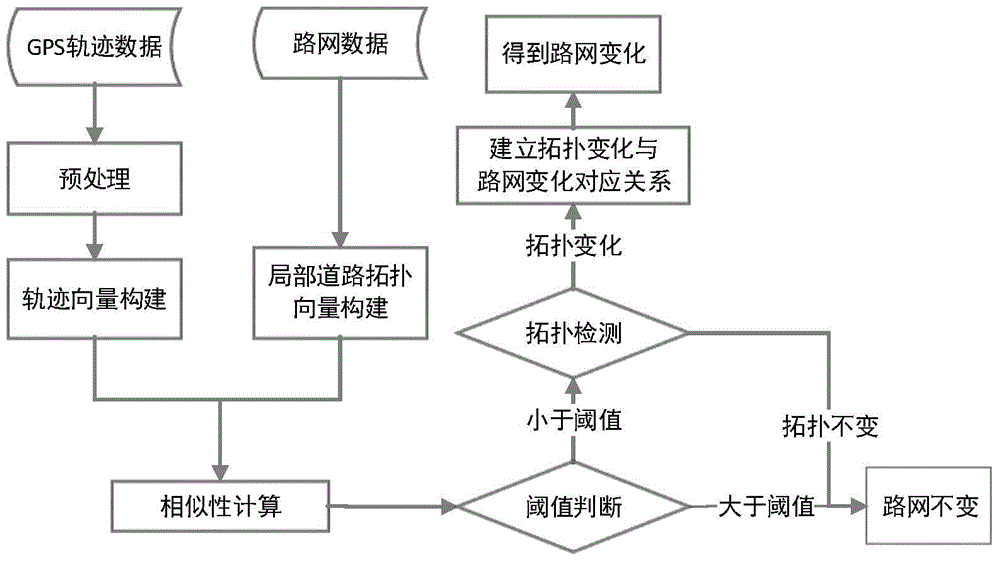
[0073] The present invention can be realized by vehicle-mounted GPS, and the essence of the present invention is: the road topology relationship represented by the vehicle-mounted GPS time-space trajectory is compared with the road topology relationship represented by the electronic map to obtain the road network topology change, and then realize the change detection of the road network topology. At present, the domestic taxi GPS drives in the streets of the city every day, and the GPS space-time trajectory spreads over any road and section of the city. The GPS space-time trajectory data collected by the taxi GPS can spread all over the city in a short time. By analyzing the GPS space-time trajectory The topological properties of the road network can be compared with the existing electronic map road topological relationship, and the detection of road network topology changes can be completed. The invention also establishes the corresponding relationship between the topology det...


PUM


Abstract

The invention discloses a GPS spatial-temporal trajectory-based road network topological change automatic detection method and system, and the method comprises the steps: step 1, establishing a local spatial-temporal trajectory vector based on a GPS spatial-temporal trajectory; step 2, establishing a local road topological vector based on road network data and the GPS spatial-temporal trajectory; step 3, measuring the similarity of the local spatial-temporal trajectory vector and the local road topological vector; step 4, extracting changed trajectory points and establishing a road topological relation of a local range of the changed trajectory points; step 5, comparing the road topological relation of the local range of the changed trajectory points with an original road network, thus obtaining the road network topological change. The method can automatically detect the topological and graph change of an urban road network, and realizes the change detection of a road network topology and a road network graph while improving the change detection precision of the road network; in addition, the invention has the advantages of low cost and efficiency.

Description

technical field [0001] The invention relates to a method and system for automatically detecting road network topology changes based on GPS space-time trajectory, and belongs to the field of geographic information system and intelligent transportation research. Background technique [0002] Traditional road change detection methods are mainly divided into three types according to the different data sources used: change detection of image-to-image comparison, change detection of image-to-vector comparison, and change detection of vector-to-vector comparison. These three methods The changes in the road network data are detected by comparing the map data of the two periods before and after, which often have the disadvantages of long data acquisition cycle, high cost, complex detection algorithm, difficult calculation, long detection time, and poor detection effect. [0003] Changes in urban roads mainly include new construction, reconstruction, and abandonment of urban roads. Ne...

Claims


Application Information

Patent Timeline
IPC IPC(8): G06F17/50
Inventor 唐炉亮靳晨李清泉刘章
Owner WUHAN UNIV
Why Eureka
Try Eureka