High-resolution remote-sensing image land cover change detection method based on history data mining

A remote sensing image and land cover technology, applied in the field of high-resolution remote sensing image change detection

Inactive Publication Date: 2015-09-09
INST OF GEOGRAPHICAL SCI & NATURAL RESOURCE RES CAS
View PDF3 Cites 21 Cited by
  • Summary
  • Abstract
  • Description
  • Claims
  • Application Information

AI Technical Summary

Problems solved by technology

Xian(2009) mined the information in historical land cover data and high-resolution remote sensing images in the historical period, but it is still based on pixels and oriented to medium-resolution remote sensing image land cover change detection.

Method used


Image

  • High-resolution remote-sensing image land cover change detection method based on history data mining
  • High-resolution remote-sensing image land cover change detection method based on history data mining
  • High-resolution remote-sensing image land cover change detection method based on history data mining

Examples


Embodiment Construction

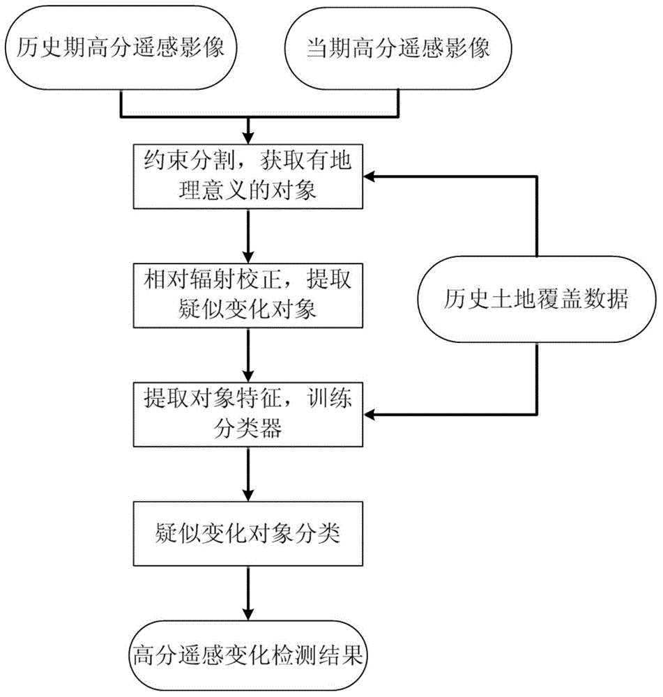
[0050] The method for detecting land cover changes in high-resolution remote sensing images based on historical data mining of the present invention will be described in detail below in conjunction with an experiment in a local area along the coast.

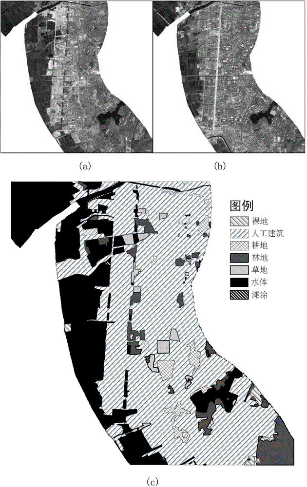
[0051] In the embodiment of the present invention, the historical high-resolution remote sensing images and the current high-resolution remote sensing images used are respectively the SPOT5 multispectral images of October 23, 2003 and November 9, 2010 (see figure 2 (a) and (b)), including four bands: green band (0.49-0.61um), red band (0.61-0.68um), near-infrared (0.78-0.89um) and short-wave infrared (1.58-1.78um ), the resolution of SWIR is 20 meters, and the resolution of others is 10 meters. In addition, the historical land cover data used in this example are based on the results obtained by manual visual interpretation of SPOT5 images in 2003 and comprehensive ground surveys (see figure 2 in (c)).

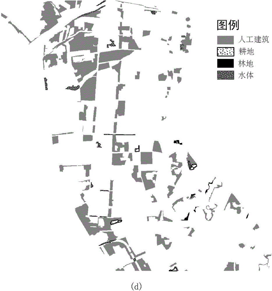
[0052] This example is...


PUM


Abstract

The present invention relates to a high-resolution remote-sensing image land cover change detection method based on history data mining, which comprises: acquiring historical land cover data, a corresponding history period high-resolution remote-sensing image and a current high-resolution remote-sensing image and under the constraint of the historical land cover data, segmenting the high-resolution remote-sensing image by using an image segmentation algorithm to obtain objects with homogeneous internal spectrums and textures; selecting part of unchanged objects, carrying out relative radiometric correction on the high-resolution remote-sensing image in two periods, and dividing the rest of objects into unchanged objects and suspected changed objects by using a mean square error obtained upon radiometric correction as a threshold; extracting spectrum and texture characteristics of the objects in the history period image and acquiring a classification rule by using a machine learning algorithm; and classifying the suspected changed objects in the current high-resolution remote-sensing image by using the classification rule so as to obtain a change detection result. The high-resolution remote-sensing image land cover change detection method according to the present invention has great application prospects in the aspect of using the high-resolution remote-sensing images to automatically update the land cover data, carry out change detection or carry out classification.

Description

technical field [0001] The invention relates to the technical field of high-resolution remote sensing image change detection, in particular to a high-resolution remote sensing image land cover change detection method based on historical data mining. Background technique [0002] The spatial distribution of land cover reflects the process of human social and economic activities and determines the balance of water, heat and matter on the surface. Its changes directly affect the biogeochemical cycle, change the land-atmosphere water, energy and carbon cycle, and even cause climate change. . Scientifically and accurately measuring the spatial distribution and dynamic changes of global land cover is of great significance for the study of the energy balance of the earth system, carbon cycle and other biogeochemical cycles, and climate change (see literature: Chen Jun, Chen Jin, Gong et al. Peng, et al. Global Land Cover High Resolution Remote Sensing Mapping [J]. Geographic Infor...

Claims


Application Information

Patent Timeline
Patent Type & Authority Applications(China)
IPC IPC(8): G06T7/40
CPCG06T7/40G06T2207/10032
Inventor 杨晓梅王志华周成虎
Owner INST OF GEOGRAPHICAL SCI & NATURAL RESOURCE RES CAS
Why Eureka
Try Eureka