Built environment landscape characteristic recognition method based on internet picture

A feature recognition and environmental technology, applied in the field of urban planning and urban landscape research, can solve problems such as interpretation of image content and shooting behavior information

Active Publication Date: 2015-09-23
SOUTH CHINA UNIV OF TECH
View PDF4 Cites 7 Cited by
  • Summary
  • Abstract
  • Description
  • Claims
  • Application Information

AI Technical Summary

Problems solved by technology

[0004] Yang Junyan and Shi Yi disclosed a rapid acquisition and measurement method of the orthophoto image of the city skyline and facade in the invention patent application with the application number 201310097613.7, but did not interpret the content of the image and the shooting behavior information

Method used


Image

  • Built environment landscape characteristic recognition method based on internet picture
  • Built environment landscape characteristic recognition method based on internet picture
  • Built environment landscape characteristic recognition method based on internet picture

Examples


Embodiment 1

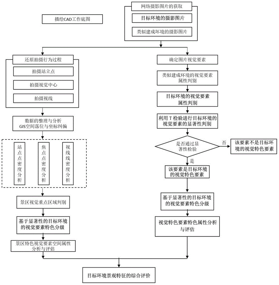
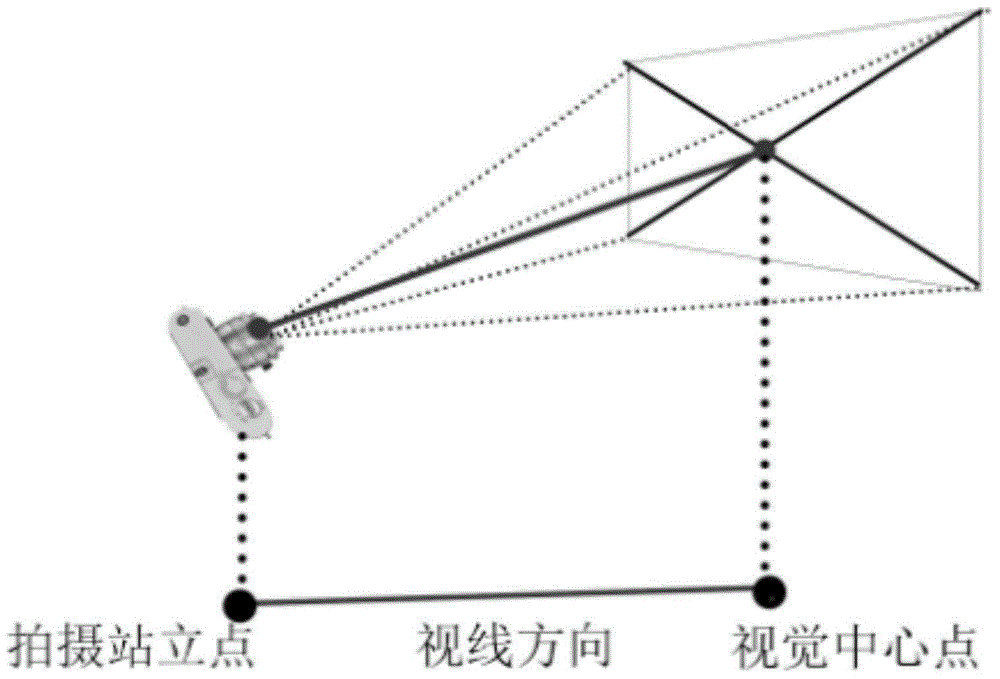
[0061] Such as figure 1 As shown, the network image-based built-environment landscape feature recognition method of the present embodiment includes the following steps:

[0062] 1) Acquisition of target environment and similar built environment network photography image library

[0063] The built environment refers to the urban environment that has been constructed in the city, the target environment refers to the built environment that needs to be identified for landscape features, and the similar built environment refers to other built environments that are of the same category as the target environment and have similarity and comparability; The significance test between the similar built environment and the target environment can obtain the elements with more significant differences in the target environment than the similar built environment, that is, the characteristic elements of the target environment.

[0064] 1.1) Use Baidu pictures to query the name of the target en...

Embodiment 2

[0108] This embodiment is an application example. The Yuyinshanfang Scenic Spot in Panyu District, Guangzhou is selected to provide a comprehensive evaluation method for the visual information of scenic spots based on network pictures. Lingnan Gardens.

[0109] 1) Acquisition of Yuyin Shanfang's network photography image library

[0110] 1.1) Use Baidu pictures to query the keyword "Yuyinshanfang", and download all the image search results in order, delete the pictures that are not related to Yuyinshanfang in the picture search results, and select the first 1200 pictures in the image search results as the Yuyinshanfang network photography picture gallery;

[0111] 1.2) Use Baidu pictures to query keywords of similar built environments in Guangzhou. In this example, select "Yuexiu Park", "Tianhe Park", "Liwan Lake Park", "Dafushan Forest Park", "Dongshan Lake Park", and "People's Park" , and download all the image search results in order, respectively. Delete the pictures ir...


PUM


Abstract

The invention discloses a built environment landscape characteristic recognition method based on an internet picture, wherein the recognition method comprises the steps as follows: using the Baidu picture search engine to obtain photographic picture libraries of a target environment and a similar built environment; recording a shooting standing point, a shooting vision central point and a shooting sight line of a shooting behavior in the target environment and importing the recorded information in an analysis platform of ArcGIS, and using ArcGIS software to analyze a visual sensitive region of the target environment in the internet picture and analyzing the sensitivity; by using the network photographic picture libraries of the target environment and the similar built environment, recording feature attributes of the network photographic pictures of the two network photographic picture libraries, and using the independent-sample T test to select a vision characteristic feature of the target environment. Thus, the landscape characteristic of a target built environment is recognized and analyzed. The built environment landscape characteristic recognition method based on the internet picture of the invention could be used for performing visual image analysis to the landscape of a city built environment, and have replicability and operability. The built environment landscape characteristic recognition method based on the internet picture of the invention could use photographer visual analysis of the internet picture and reduction analysis of the shooting behavior, and have timeliness and objectivity.

Description

technical field [0001] The invention relates to a built environment landscape feature recognition method, in particular to a built environment landscape feature recognition method based on network pictures, which belongs to the urban landscape research field in the urban planning field. Background technique [0002] Identifying the landscape features of the urban environment is the premise and foundation of urban and rural planning and design, and people's photography behavior provides a lot of material for identifying the landscape features of the environment. The visual research of tourism destinations with photographic pictures has always been a hot spot for scholars. [0003] At this stage, many scholars study the visual intentions of cities or neighborhoods through media expression. For example, Liu Jing studies the spatial images of multiple cities with the help of movie images. landscape of a city. However, there is no relevant research on the use of network images ...

Claims


Application Information

Patent Timeline
IPC IPC(8): G06F17/50
CPCG06F30/00
Inventor 赵渺希顾沁贾锐澜吴江月
Owner SOUTH CHINA UNIV OF TECH
Why Eureka
Try Eureka