GPS (global positioning system) geographic position data mining based user classification method

A technology of geographic location and data mining, applied in the field of big data analysis, can solve the problems of loss of effective information and low efficiency, and achieve the effect of avoiding information redundancy, improving operation speed and efficiency, and improving value extraction.

Active Publication Date: 2015-10-07
CHONGQING UNIV OF POSTS & TELECOMM
View PDF3 Cites 33 Cited by
  • Summary
  • Abstract
  • Description
  • Claims
  • Application Information

AI Technical Summary

Problems solved by technology

This algorithm is first of all low in efficiency, it needs to process the user's movement trajectory sequence, and it needs to be layered and clustered multiple times to complete the classification of users; secondly, this algorithm is too strict in the research of user classification, and some effective data will be lost. information

Method used


Image

  • GPS (global positioning system) geographic position data mining based user classification method
  • GPS (global positioning system) geographic position data mining based user classification method
  • GPS (global positioning system) geographic position data mining based user classification method

Examples


Embodiment Construction

[0046] Below in conjunction with accompanying drawing, the present invention will be further described:

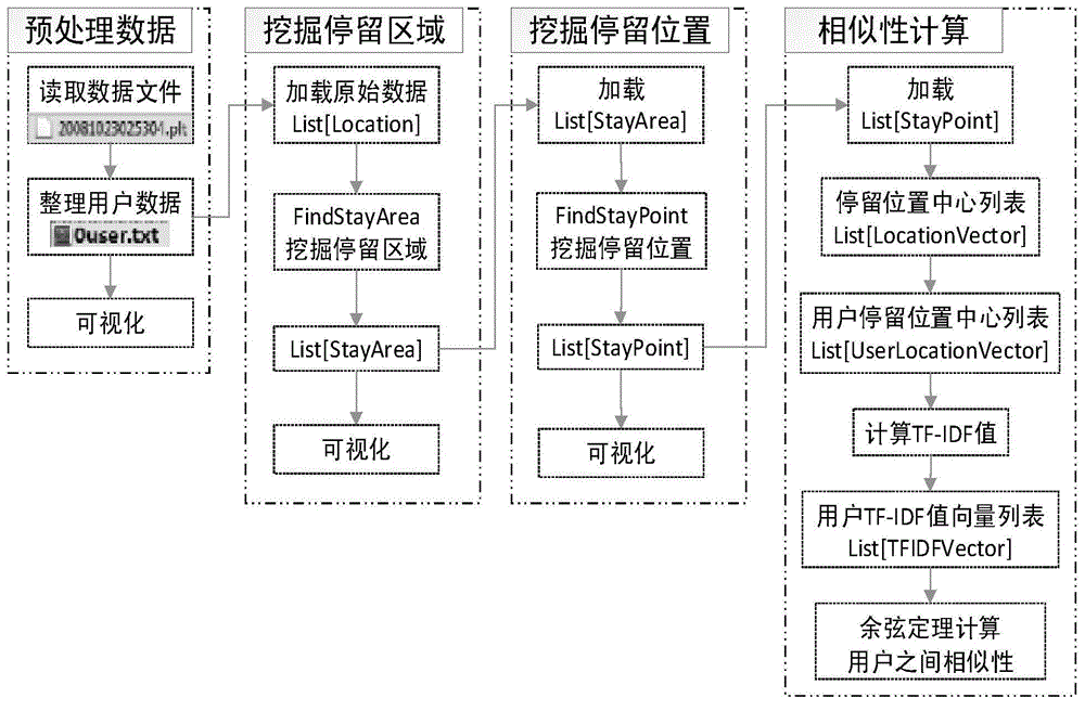
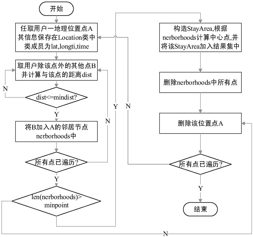
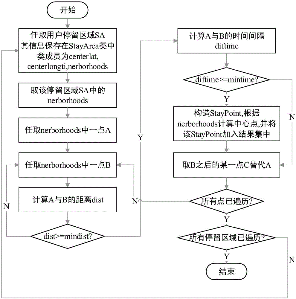
[0047] see figure 1 , the invention provides a kind of user classification method based on GPS geographic position data mining, and it comprises the steps:

[0048] The first step is to preprocess the original GPS geographic location data, extract the data attributes required by the algorithm, and organize them according to the user; classify the user's original GPS geographic location data by folder, and traverse all folders that store the user's original GPS geographic location data. file, extract the three attributes of latitude, longitude, and recording time, and use the user ID as the file name of the output file.

[0049] Such as figure 1 As shown, the present invention firstly needs to extract effective information from the original collected data, and sort them out by user ID, then read the original GPS geographic location data set from the same sorted file, and ...


PUM


Abstract

The invention relates to a GPS (global positioning system) geographic position data mining based user classification method which comprises the following steps of: preprocessing an initial data set, extracting data attribute required by an algorithm and summing up and sorting out the data attribute by taking users as units; mining staying regions of the users through a FindStayArea algorithm, and finding out large-range activity regions (such as a workplace region, a residential quarter and the like) of the users; then mining staying positions, namely activity positions (such as a building in the workplace region, a stadium in the residential quarter and the like), of the users through a FindStayPoint algorithm; and finally, classifying the users by combining the staying positions of the users with a UserClassify algorithm. According to the method, original GPS geographic position data of the users is subjected to hierarchical processing, so that the staying positions in which the users often perform activities can be mined, the users also can be classified by utilizing a mining result, a user group with highest similarity is found, and the value of the GPS geographic position data is fully mined.

Description

technical field [0001] The invention relates to the technical field of big data analysis, and relates to the analysis and processing of GPS geographic location data in mobile big data by using machine learning algorithms, and in particular to a user classification method based on GPS geographic location data mining. Background technique [0002] With the explosive development of mobile smart terminals and the maturity of positioning technology, not only a large number of location-based service (Location Based Service, LBS) applications have been spawned, but also the generation of mobile big data (Mobility Big Data, MBD). With the continuous popularization and development of location services, Internet of Vehicles applications, and various positioning technologies, mobile big data consisting of geographic data, vehicle and person trajectories, and application records has become a tool currently used to perceive the laws of human community activities and analyze them. Geograp...

Claims


Application Information

Patent Timeline
Patent Type & Authority Applications(China)
IPC IPC(8): G06F17/30
CPCG06F16/29G06F16/35
Inventor 徐光侠高诗意常光辉刘宴兵梁绍飞林福弈胡杰李来军吴群
Owner CHONGQING UNIV OF POSTS & TELECOMM
Why Eureka
Try Eureka