Street view map production method, control server, unmanned aerial vehicle and production device

A technology for controlling servers and production methods, applied to maps/plans/charts, three-dimensional position/channel control, instruments, etc., which can solve the problems of high production cost of street view maps, low efficiency of street view map production, and slow update speed of street view maps, etc. Achieve the effect of improving production efficiency

Inactive Publication Date: 2015-11-04
高域(北京)智能科技研究院有限公司
View PDF8 Cites 28 Cited by
  • Summary
  • Abstract
  • Description
  • Claims
  • Application Information

AI Technical Summary

Problems solved by technology

[0009] Embodiments of the present invention provide a street view map production method, a control server, an unmanned aerial vehicle, and a production method with higher street view map production efficiency, faster street view map update speed, and lower street view map production cost. device; to solve

Method used


Image

  • Street view map production method, control server, unmanned aerial vehicle and production device
  • Street view map production method, control server, unmanned aerial vehicle and production device
  • Street view map production method, control server, unmanned aerial vehicle and production device

Examples


Embodiment Construction

[0053] Referring to the drawings, where like reference numerals represent like components, the principles of the present invention are exemplified by being implemented in a suitable computing environment. The following description is based on illustrated specific embodiments of the invention, which should not be construed as limiting other specific embodiments of the invention not described in detail herein.

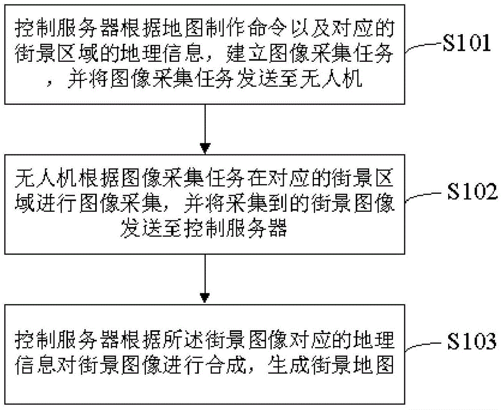
[0054] The street view map production device of the present invention includes an unmanned aerial vehicle and a control server. The control server can be various mobile or fixed electronic terminals, and the electronic terminal controls the unmanned aerial vehicle to collect street view images, which improves the production efficiency of the street view map. , Speed ​​up the update speed of the street view map and reduce the production cost of the street view map.

[0055] Please refer tofigure 1 , figure 1 It is a flow chart of a preferred embodiment of the street view...


PUM


Abstract

The invention provides a street view map production method, a control server, an unmanned aerial vehicle and a production device. The street view map production method includes the following steps that: the control server establishes an image acquisition task according to a map production command and the geographic information of a corresponding street view region, and transmits the image acquisition task to the unmanned aerial vehicle; the unmanned aerial vehicle performs image acquisition on the corresponding street view region according to the image acquisition task and transmits acquired street view images to the control server; and the control server fuses the street view images according to geographic information corresponding to the street view images, so as to generate a street view map. The street view map production method, the control server, the unmanned aerial vehicle and the production device provided by the invention have the advantages of high street view map production efficiency, high street view map updating speed and low street view map production cost.

Description

technical field [0001] The invention relates to the field of electronic maps, in particular to a method for making a street view map, a control server, an unmanned aerial vehicle and a making device. Background technique [0002] With the application of electronic maps more and more widely, users put forward high requirements on the functions of electronic maps. Taking the 3D model of a real building displayed in the street view as an example, this display method has a strong sense of situation, which can make the user have an immersive feeling and can greatly improve the user experience. [0003] However, the production process of existing street view maps is limited by many factors, such as manpower, equipment, and means of transportation. In real life, due to the rapid pace of urban construction and other reasons, various scenes in reality are constantly changing, so the pictures that previously existed on the Internet can no longer accurately reflect the current actual ...

Claims


Application Information

Patent Timeline
IPC IPC(8): G05D1/10G09B29/00
Inventor 杨珊珊
Owner 高域(北京)智能科技研究院有限公司
Why Eureka
Try Eureka