Eureka AIR delivers breakthrough ideas for toughest innovation challenges, trusted by R&D personnel around the world.

Civil beidou system positioning measurement device and surveying and mapping method

A positioning measurement and Beidou system technology, applied in the field of surveying and mapping instruments, can solve the problems of insufficient compass surveying and mapping accuracy and inability to accurately measure the object to be measured.

Inactive Publication Date: 2015-12-02
张永龙
View PDF1 Cites 1 Cited by
  • Summary
  • Abstract
  • Description
  • Claims
  • Application Information

AI Technical Summary

Problems solved by technology

Because the earth itself is in the magnetic field, the strength of the magnetic field varies from place to place on the earth, so that the accuracy of compass surveying and mapping is not enough, and the coordinates of the measured object cannot be measured accurately when a coordinate is known. For example, if you want to map an object The coordinates of the geographic location, but if you know your own coordinates, you can’t map them with this compass, or if you know the geographic location coordinates of the object, you want to map your own coordinates, but you can’t map them with this compass

Method used


Image

  • Civil beidou system positioning measurement device and surveying and mapping method
  • Civil beidou system positioning measurement device and surveying and mapping method
  • Civil beidou system positioning measurement device and surveying and mapping method

Examples


Embodiment Construction

[0042] In order to make the object, technical solution and advantages of the present invention clearer, the present invention will be further described in detail below in conjunction with the accompanying drawings and embodiments. It should be understood that the specific embodiments described here are only used to explain the present invention, not to limit the present invention.

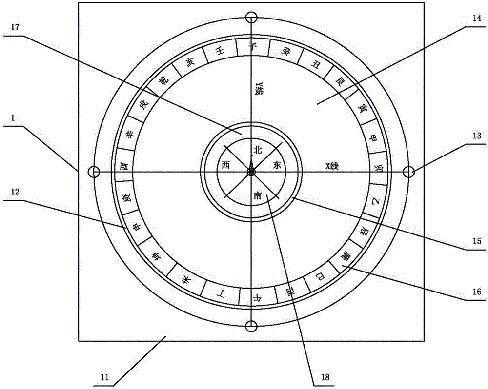
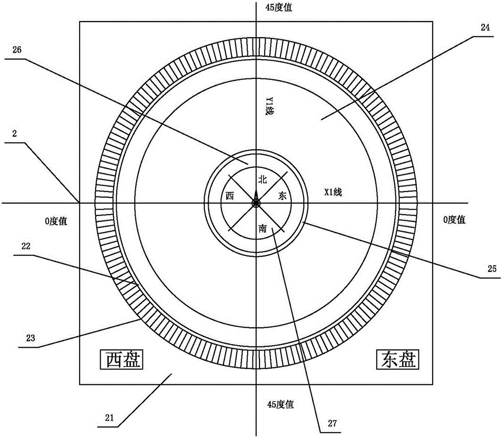
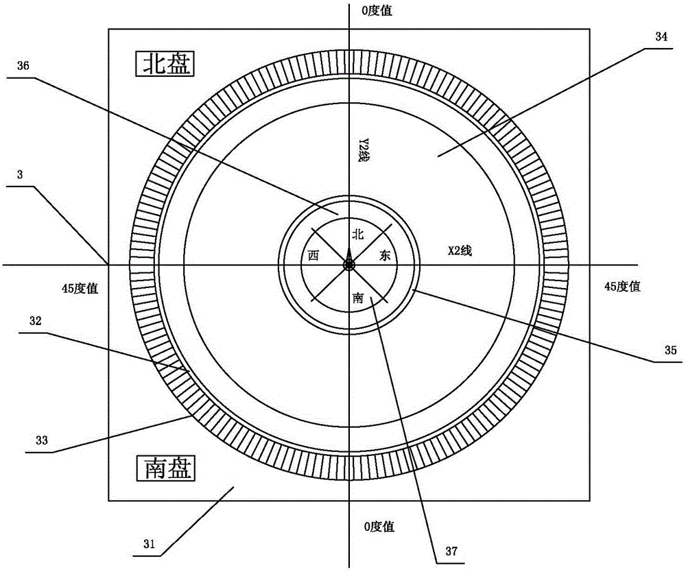
[0043] Such as figure 1 , figure 2 , image 3 , Figure 4 , Figure 5 , Figure 6 , Figure 7 , Figure 8 , Figure 9 , Figure 10 , Figure 11 As shown, a civil Beidou system positioning and measuring device of the present invention includes an ancient compass 1 , a meridian 2 and a latitude 3 . The ancient compass 1 includes a first base 11, a first disc 14 and a first box 17, the first base 11 is provided with: four small holes 13, a first circular groove 12 at the center of the first base 11 , the surface of the first base 11 is square, the four small holes 13 are locat...


PUM


Abstract

The invention relates to a surveying and mapping instrument, particularly relates to a civil beidou system positioning measurement device and also relates to a surveying and mapping method. According to the civil beidou system positioning measurement device, an ancient compass is applied and corrected, a first disc is rotated so as to further drive a first compass, and a longitude disc and a latitude disc are selected according to laws; in the longitude disc, a second disc is rotated so as to further drive a second compass, and the different grid numbers can be measured, so that the needed longitude can be calculated; in the latitude disc, a third disc is rotated so as to further drive a third compass, and the different grid numbers can be measured, so that the needed latitude can be calculated; according to the longitude and the latitude, the needed geographic position can be known. According to the civil beidou system positioning measurement device and the surveying and mapping method, the interference is slight, the error is small, the surveying and mapping are accurate, and the use is wide.

Description

technical field [0001] The invention relates to a surveying and mapping instrument, in particular to a civil Beidou system positioning and measuring device and a surveying and mapping method thereof. Background technique [0002] The compass is one of the four great inventions in ancient China. It was first used for navigation. The compass mainly includes a magnetic needle and a chassis. The compass is a basic tool for measuring the magnetic azimuth of the earth's surface. It is widely used in military affairs, navigation, surveying and mapping, forestry, exploration, construction, etc. each field. The compass is used on the compass, mainly used for geomantic geography testing, etc. The compass is composed of three parts: Tianchi, inner disk and outer disk. Tianchi is also called the seabed, which is the compass. It is composed of a cover, which is fixed in the center of the inner disk. There is a pointed thimble in the center of the bottom surface of the cylindrical outer ...

Claims


Application Information

Patent Timeline
IPC IPC(8): G01C17/04
CPCG01C17/04
Inventor 张永龙
Owner 张永龙
Why Eureka
Eureka Blog
Learn More