Underwater carrier positioning method

An underwater positioning and carrier technology, applied in satellite radio beacon positioning system, sound wave re-radiation, measuring devices, etc., can solve problems such as unrealistic global deployment, complex system, and impact on positioning accuracy

Active Publication Date: 2015-12-23
BEIJING INSTITUTE OF TECHNOLOGYGY
View PDF2 Cites 14 Cited by
  • Summary
  • Abstract
  • Description
  • Claims
  • Application Information

AI Technical Summary

Problems solved by technology

Its basic principle is similar to GPS positioning, but multiple buoys need to be deployed in the specific implementation process, the whole system is relatively complex, and the sea surface buoys are interfered by various err

Method used


Image

  • Underwater carrier positioning method
  • Underwater carrier positioning method
  • Underwater carrier positioning method

Examples


example

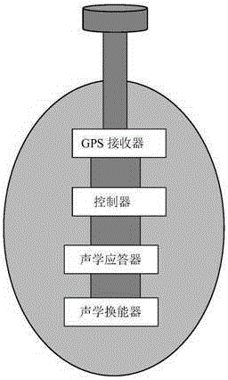
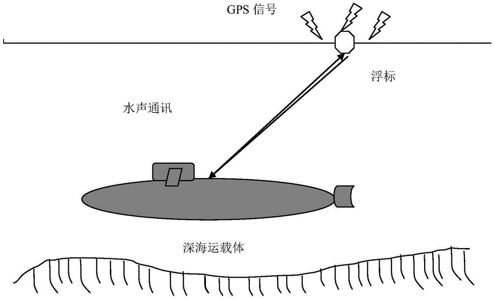
[0037] The underwater vehicle equipped with the INS / USBL integrated navigation system needs to readjust and calibrate its inertial navigation system during the long-term voyage, and sends inquiries underwater according to the working frequency of the transponder deployed underwater or the buoy carrying the transponder signal, the transponder receives and sends back a response signal, and the inertial navigation system / underwater acoustic ultra-short baseline system / GPS integrated navigation system can calculate the accurate information of the underwater carrier through the matrix transformation theory, and readjust and calibrate the inertial navigation system .

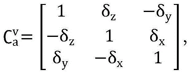
[0038] Set the position of the inertial navigation system in the Cartesian coordinate system (north, east, ground, that is, the navigation coordinate system) as: (X v , Y v ,Z v )′, the "apparent position" of the transponder or buoy in the ultra-short baseline matrix coordinate system is: The position of the referen...


PUM


Abstract

The invention provides an underwater carrier positioning method which comprises the following specific steps: 1) equipping an inertial navigation system and an underwater acoustic ultra-short baseline positioning system to a carrier; 2) judging whether an underwater transponder exists within a range that underwater acoustic information of the underwater acoustic ultra-short baseline positioning system can reach, and if so, turning to the step 6), or otherwise, turning to the step 3); 3) the carrier releasing a buoy equipped with a GPS receiver; 4) the carrier receiving GPS signals of the buoy, and the underwater acoustic ultra-short baseline positioning system measuring position information of the buoy in an ultra-short baseline array coordinate system; 5) calculating position of the carrier in the navigation coordinate system according to the GPS signals and the position information, and carrying out calibration on the inertial navigation system; and 6) calculating the position of the carrier in the navigation coordinate system according to the position information of the underwater transponder in the navigation coordinate system and the position information thereof in the ultra-short baseline array coordinate system, and carrying out calibration on the inertial navigation system. The method realizes underwater positioning of the carrier.

Description

technical field [0001] The invention belongs to the technical field of combined navigation of an inertial navigation underwater system / underwater acoustic positioning system / GPS, and in particular relates to a method for underwater positioning of a carrier. Background technique [0002] In the past half a century, due to the development needs of science and technology, economy, military and other aspects of the world, the underwater target navigation and positioning technology has been developed rapidly. Underwater space stations, marine exploration, submarine optical cables, submarine pipeline laying and maintenance, underwater submersible navigation and positioning, oil and gas well positioning, underwater construction and other fields need to solve the problem of accurate underwater navigation and positioning. Gradually, a batch of underwater acoustic positioning equipment using underwater acoustics for positioning has emerged. It determines the relative distance and dire...

Claims


Application Information

Patent Timeline
IPC IPC(8): G01S19/47G01S15/06
CPCG01S15/06G01S19/47
Inventor 汪湛清胡小毛王彬王彦国赵亮张延顺
Owner BEIJING INSTITUTE OF TECHNOLOGYGY
Why Eureka
Try Eureka