Travel space-time analysis method based on taxi GPS data map matching

A technology of GPS data and spatio-temporal analysis, applied in traffic flow detection, etc., can solve problems such as difficult to accurately reflect vehicle driving position and driving trajectory, weaken GPS device receiving and sending signals, and low precision of civil GPS positioning device, etc., to achieve sufficient data , Improve efficiency, high efficiency effect

Active Publication Date: 2016-01-20
SUN YAT SEN UNIV
View PDF1 Cites 21 Cited by
  • Summary
  • Abstract
  • Description
  • Claims
  • Application Information

AI Technical Summary

Problems solved by technology

This is because on the one hand, the accuracy of civilian GPS positioning devices is generally low, and errors caused by device failures; on the other hand, buildings on both sides of urban roads and trees will weaken the receiving and sending signals of GPS devices and cause drift.
Theref

Method used


Image

  • Travel space-time analysis method based on taxi GPS data map matching
  • Travel space-time analysis method based on taxi GPS data map matching
  • Travel space-time analysis method based on taxi GPS data map matching

Examples


Embodiment 1

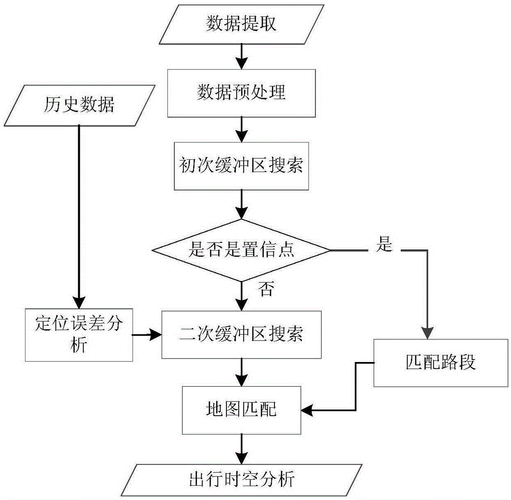
[0057] The electronic map of Guangzhou City, Guangdong Province, China and the GPS data of all taxis in Guangzhou City on a certain day are used as floating car data for path matching simulation analysis. The original data sampling rate is 20-30s. When the taxi is in the passenger state, the vehicle sends a GPS data every 20s, and when the taxi is empty, it sends a GPS data every 30s. When the state of the vehicle changes, the GPS device immediately sends A piece of GPS data, but because some data points will be lost during the collection and transmission process, the GPS sampling rate used in the experiment is low, which belongs to the low sampling rate floating car data. The specific operation steps are:

[0058] Step 1: Taxi GPS data preprocessing

[0059] 1) The data used are all valid data, that is, the valid field values ​​of the data in the test are all 1;

[0060] 2) Delete duplicate data, if two GPS data have the same license plate and the same time, then these two ...


PUM


Abstract

The invention provides a travel space-time analysis method based on taxi GPS data map matching. Original taxi GPS data are extracted and pretreatment on the data is carried out; historical data are analyzed, a taxi GPS positioning error accumulation distribution mode is determined, and a secondary buffer region searching method is constructed; taxi travel data are extracted and a positioning point is matched to a road by combining a taxi GPS data direction element and a distance element map establishment matching method; and a travel space distribution feature identification method is established and a travel space-time distribution feature is analyzed by using the matched taxi GPS data. According to the invention, the taxi GPS positioning error distribution feature is analyzed by using massive historical data fully; a taxi GPS positioning point matching efficiency is improved by constructing the secondary buffer region searching method; and a travel distribution effect can be identified and analyzed effectively by using the established distribution feature identification method. The method has the great significance in improving the taxi map matching effect, floating vehicle information collection, and a travel space-time analysis effect and a data support can be provided for the city traffic planning.

Description

technical field [0001] The invention relates to the technical field of traffic planning application, and more specifically, relates to a travel time-space analysis method based on taxi GPS data map matching. Background technique [0002] Taxis play an important role in urban transportation. Taking Guangzhou as an example, more than 17,000 taxis drive on the urban road network every day, almost covering the main roads of the city, and there are vehicles operating on the roads 24 hours a day , Massive data, high coverage, long duration. Compared with other data collection methods such as mobile phone data, Bluetooth, and bus positioning data, taxis are used as floating vehicles for traffic information collection, which can realize traffic state analysis and prediction, travel time and space analysis, road speed estimation and taxi operation management, etc. has unique advantages. It is of great significance in improving the perception of urban road traffic status, alleviatin...

Claims


Application Information

Patent Timeline
IPC IPC(8): G08G1/01
Inventor 李军武品杰赵长相
Owner SUN YAT SEN UNIV
Why Eureka
Try Eureka