Method for accurately identifying ground features in satellite remote-sensing image

A satellite remote sensing image and satellite remote sensing technology, which is applied in the field of satellite remote sensing image recognition, can solve problems such as restricting the application of high-resolution remote sensing images, and achieve the effect of accurate detection and recognition and avoidance of interference.

Inactive Publication Date: 2016-02-03
CHINA UNIV OF MINING & TECH (BEIJING)
View PDF3 Cites 20 Cited by
  • Summary
  • Abstract
  • Description
  • Claims
  • Application Information

AI Technical Summary

Problems solved by technology

However, there is no more accurate and complete object-oriented analysis scheme for high-resolution remote sensing images, which seriously restricts the application of high-resolution remote sensing images in many fields.

Method used


Image

  • Method for accurately identifying ground features in satellite remote-sensing image
  • Method for accurately identifying ground features in satellite remote-sensing image
  • Method for accurately identifying ground features in satellite remote-sensing image

Examples


Embodiment Construction

[0031] The technical solutions in the embodiments of the present invention will be clearly and completely described below in conjunction with the accompanying drawings in the embodiments of the present invention. Obviously, the described embodiments are only some of the embodiments of the present invention, not all of them. Based on the embodiments of the present invention, all other embodiments obtained by persons of ordinary skill in the art without making creative efforts belong to the protection scope of the present invention.

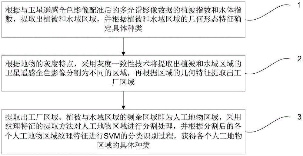
[0032] Such as figure 1 As shown, a schematic diagram of a method for accurately identifying ground objects in satellite remote sensing images is provided for an embodiment of the present invention, which mainly includes the following steps:

[0033] Step 1. According to the vegetation index and water body index of the multispectral image data registered with the satellite remote sensing panchromatic image, the vegetation and water area are extract...


PUM


Abstract

The invention discloses a method for accurately identifying ground features in a satellite remote-sensing image. The method comprises steps of: extracting vegetation and water areas according to a vegetation index and a water index of multispectral image data registered with a satellite remote-sensing panchromatic image, and determining a specific category according to the geometrical morphological characteristics of the vegetation and water areas; according to the gray characteristics of the ground features, segmenting the extracted satellite remote-sensing panchromatic image of the vegetation and water areas into different areas by using gray consistency technology, and extracting factory areas according to the geometrical characteristics of the areas; determining that the rest areas are man-made ground feature areas after the factory areas and the vegetation and water areas are extracted, segmenting the man-made ground feature areas by using a textural feature extracting method, and performing a SVM classification identification process according to the textural feature of each segmented man-made ground feature area in order to obtain the specific category of each man-made ground feature area. The method may accurately detect and identify the ground features in the satellite remote-sensing image.

Description

technical field [0001] The invention relates to the field of satellite remote sensing image recognition, in particular to a method for accurately recognizing ground objects in satellite remote sensing images. Background technique [0002] Satellite remote sensing image object recognition plays an important role as the basis of surface change monitoring. Through the detection and identification of ground objects, analysis of changes in the earth's environment and resources, detection and early warning of natural disasters, and the collection of a large amount of natural and human activity information, it can be widely used in the fields of national economy and military affairs. Due to the lack of appropriate evaluation criteria and theoretical basis, the existing remote sensing image ground object change detection technology is mostly through simple pixel analysis, without forming an automatic change detection method system and the future geometric feature information of the ...

Claims


Application Information

Patent Timeline
Patent Type & Authority Applications(China)
IPC IPC(8): G06K9/00
CPCG06V20/188G06V20/13G06V20/20
Inventor 张国英李孟军宋科科
Owner CHINA UNIV OF MINING & TECH (BEIJING)
Why Eureka
Try Eureka