System and method for identifying agricultural disaster scope based on high-resolution remote sensing image

A remote sensing image, high-resolution technology, applied in the field of satellite remote sensing, to solve information asymmetry, improve the accuracy and efficiency of underwriting and claims settlement

Inactive Publication Date: 2016-03-09
INST OF REMOTE SENSING & DIGITAL EARTH CHINESE ACADEMY OF SCI
View PDF2 Cites 50 Cited by
  • Summary
  • Abstract
  • Description
  • Claims
  • Application Information

AI Technical Summary

Problems solved by technology

[0006] The present invention aims

Method used


Image

  • System and method for identifying agricultural disaster scope based on high-resolution remote sensing image
  • System and method for identifying agricultural disaster scope based on high-resolution remote sensing image
  • System and method for identifying agricultural disaster scope based on high-resolution remote sensing image

Examples


Embodiment Construction

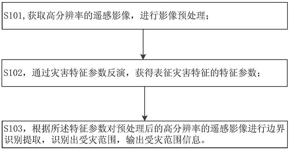
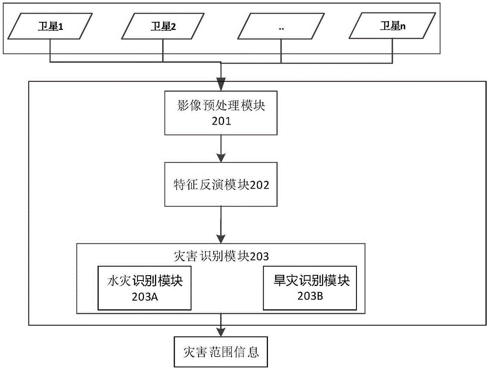
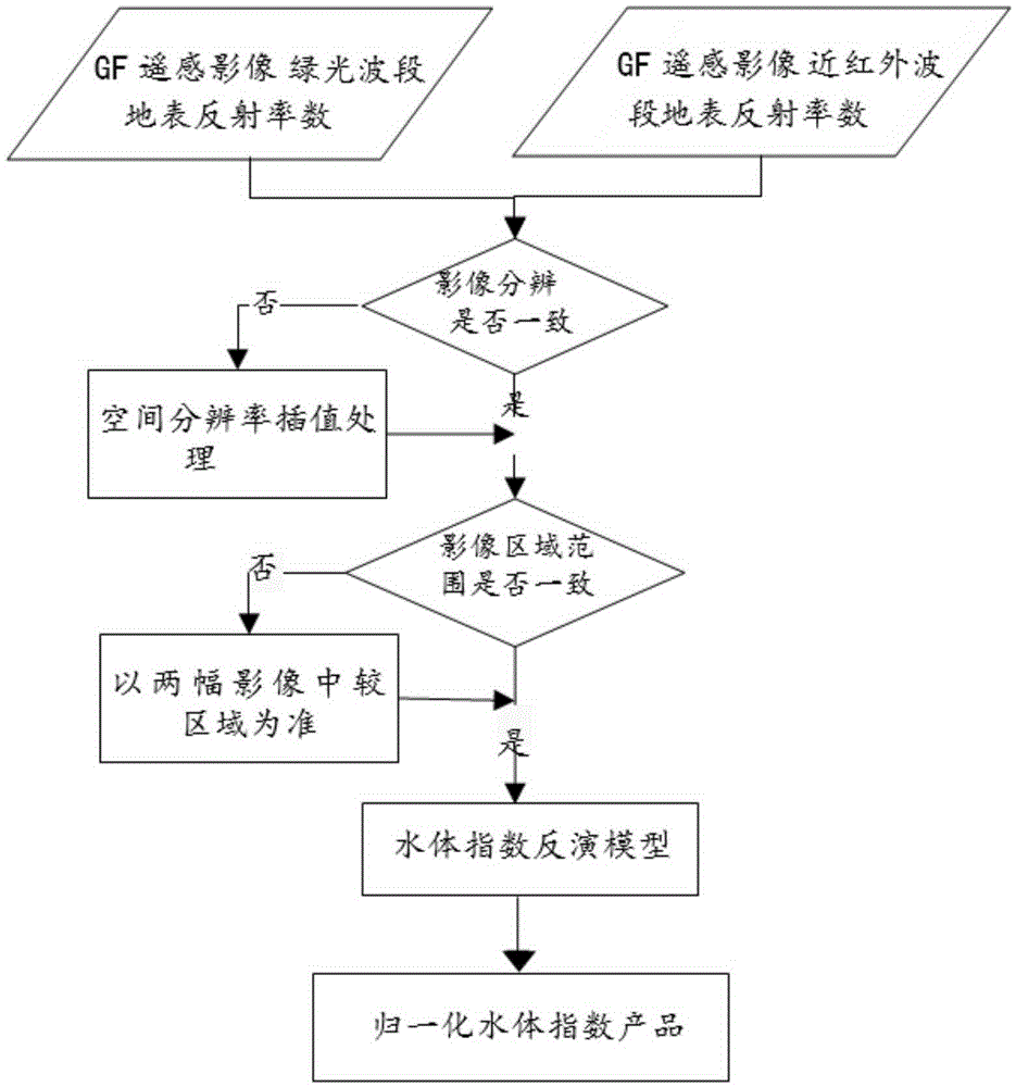
[0036] In order to make the purpose, technical solutions and advantages of the embodiments of the present invention clearer, the technical solutions in the embodiments of the present invention will be clearly and completely described below in conjunction with the drawings in the embodiments of the present invention. Obviously, the described embodiments It is a part of embodiments of the present invention, but not all embodiments. Based on the embodiments of the present invention, all other embodiments obtained by persons of ordinary skill in the art without making creative efforts belong to the protection scope of the present invention. It should be noted that, in the case of no conflict, the embodiments in the present application and the features in the embodiments can be combined arbitrarily with each other.

[0037] The main content of the present invention includes obtaining remote sensing high-resolution data, and obtaining various parameters characterizing disaster chara...


PUM


Abstract

The present invention provides a system and a method for identifying an agricultural disaster scope based on a high-resolution remote sensing image. The system comprises an image preprocessing module, a characteristic inversion module and a disaster identification module. The method comprises the steps of: obtaining a high-resolution remote sensing image and performing image preprocessing; obtaining characteristic parameters representing disaster characteristics through disaster characteristic parameter inversion; performing boundary identification and extraction for the preprocessed high-resolution remote sensing image according to the characteristic parameters, identifying a disaster scope, and obtaining disaster scope information. Through adoption of the system and the method of the present invention, the insured subjects of an agricultural insurance can be identified and extracted in a remote sensing survey link of underwriting and claiming of the agricultural insurance, and an accurate disaster scope can be further obtained based on a land type classification and boundary identification and extraction algorithm for the insured subjects of an agricultural insurance.

Description

technical field [0001] The invention relates to the technical field of satellite remote sensing, in particular to a system and method for identifying agricultural disaster ranges based on high-resolution remote sensing images. Background technique [0002] Remote sensing technology is an emerging discipline developed in the middle and late 20th century. Remote sensing technology opened the prelude to human beings observing the earth and exploring the universe from outer space, and found new ways for understanding the land, developing resources, studying the environment, and analyzing global changes. In recent years, new progress has been made in satellite remote sensing resolution (space, spectrum, time), radiation accuracy, satellite operation mode, payload form, data processing, and remote sensing applications. [0003] Remote sensing technology is widely used. In the field of surveying and mapping, it can be used to make satellite image maps, land topographic maps, topogr...

Claims


Application Information

Patent Timeline
IPC IPC(8): G06K9/00G06K9/54
CPCG06V20/13G06V10/20
Inventor 柳树福池天河彭玲姚晓婧
Owner INST OF REMOTE SENSING & DIGITAL EARTH CHINESE ACADEMY OF SCI
Why Eureka
Try Eureka