Post-disaster life tracking unmanned aerial vehicle system

A technology of unmanned aerial vehicles and life, which is applied in the direction of unmanned aircraft, motor vehicles, integrated navigators, etc., can solve the problems of no consideration, etc., and achieve the effect of ensuring wrong judgment, strong flexibility, and large search range

Active Publication Date: 2016-03-23
GCI SCI & TECH
View PDF5 Cites 16 Cited by
  • Summary
  • Abstract
  • Description
  • Claims
  • Application Information

AI Technical Summary

Problems solved by technology

[0005] The above scheme only provides how to analyze the image information provided by the observer through images, but does not

Method used


Image

  • Post-disaster life tracking unmanned aerial vehicle system
  • Post-disaster life tracking unmanned aerial vehicle system
  • Post-disaster life tracking unmanned aerial vehicle system

Examples


Embodiment 1

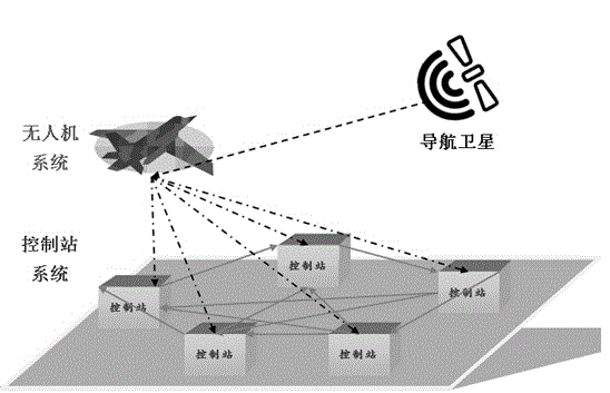
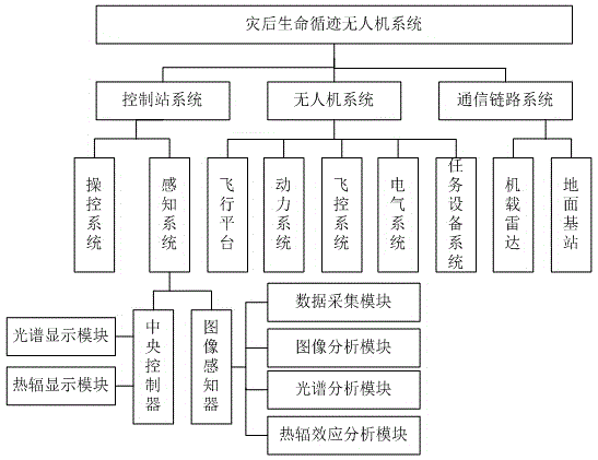
[0037] Such as Figure 1-2 As shown, a post-disaster life-tracking unmanned aerial vehicle system, said post-disaster life-tracking unmanned aerial vehicle system includes:

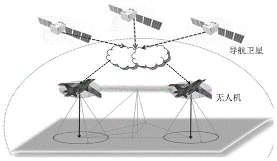
[0038] Unmanned aerial vehicle system: including at least one unmanned aerial vehicle, the unmanned aerial vehicle obtains its own position in real time through navigation satellites, flies over the post-disaster search and rescue area, collects ground images, spectra and infrared rays in real time, and sends the position, image , spectral and infrared rays are integrated, classified and analyzed and then sent to the control station;

[0039] Control station system: including at least one control station, which is used to identify vital sign signals based on the images, spectra and infrared rays collected by the drone, and draw a map representing the location of the living body in combination with the location;

[0040] Communication link system: used to provide communication links between drones and nav...


PUM


Abstract

The invention discloses a post-disaster life tracking unmanned aerial vehicle system. The post-disaster life tracking unmanned aerial vehicle system comprises an unmanned aerial vehicle system body, a control station system and a communication link system. The unmanned aerial vehicle system body comprises at least one unmanned aerial vehicle which obtains the position of the unmanned aerial vehicle in real time through a navigational satellite and flies in the sky above a post-disaster search-rescue region to collect an image, the spectrum and infrared rays of the ground in real time. In addition, the position, the image, the spectrum and the infrared rays are sent to a control station after being integrated, classified and analyzed. The control station system comprises at least one control station which is used for recognizing a vital sign signal according to the image, the spectrum and the infrared rays collected through the unmanned aerial vehicle and drawing a map presenting a life position in combination with the position. The communication link system is used for providing communication links between the unmanned aerial vehicle and the navigational satellite, between the unmanned aerial vehicle and the control station, and between the control station and a disaster relief command center. The post-disaster life tracking unmanned aerial vehicle system can overcome the influence of severe environment and collect data continuously, and has the advantages of being high in search-rescue efficiency and accurate in life locating.

Description

technical field [0001] The present invention relates to the field of post-disaster rescue systems, and more specifically, to a post-disaster life tracking UAV system. Background technique [0002] At present, there are many similar machines in the world that are used to search and rescue human beings who still have vital signs after major geological disasters such as earthquakes, tsunamis, and volcanic eruptions erupt. Nowadays, the vast majority of products use search and rescue robots to collect relevant information of survivors through sonar, remote sensing, GPS positioning, temperature and humidity measurement, etc. The odds are greatly improved. [0003] With the increasing number of global catastrophic geological movements in recent years, people's awareness of safety and security is also increasing. The worries and troubles brought by potential safety hazards to human beings have also become the biggest problems in the world today, which also means that people have ...

Claims


Application Information

Patent Timeline
IPC IPC(8): B64C39/02G01C21/24
CPCG01C21/24B64C39/02B64U2201/104B64U2101/00
Inventor 李彧张检宝陈龙飞傅仁轩
Owner GCI SCI & TECH
Why Eureka
Try Eureka