Laser altimeter vertical control point generating method in combination with stereopair

A technology of laser altimeter and elevation control point, which is applied in height/horizontal measurement, re-radiation of electromagnetic waves, measurement devices, etc., and can solve the problems of increased difficulty of waveform decomposition, large area, complex waveform, etc.

Active Publication Date: 2016-05-04
SHANGHAI INST OF TECHNICAL PHYSICS - CHINESE ACAD OF SCI
View PDF5 Cites 19 Cited by
  • Summary
  • Abstract
  • Description
  • Claims
  • Application Information

AI Technical Summary

Problems solved by technology

At the same time, since the large spot lidar spot covers a large area of ​​the ground, the waveform will be more complicated in areas with complex ground objects, which makes it more difficult to decompose the waveform.

Method used


Image

  • Laser altimeter vertical control point generating method in combination with stereopair

Examples


Embodiment Construction

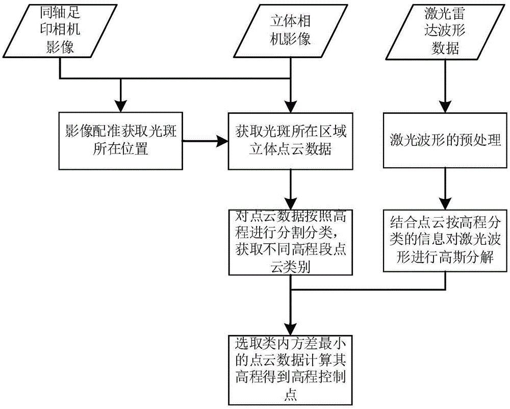
[0038] The technical scheme provided by the invention adopts the following steps:

[0039] S1 Footprint Camera Geometric Correction: Calculate the geographical coordinates of each image point of the footprint camera according to the attitude of the satellite, the installation angle of the footprint camera system, the focal length of the footprint camera and the size of the CCD, and then calculate the geographic coordinates of each image point of the footprint camera according to the obtained Geographic coordinates of the image points are used to geometrically correct the footprint camera image and the image is resampled to the same resolution as the dual line scan image.

[0040] S2 Correction of dual-line array images: Stereo matching is performed on the dual-line array images to obtain the plane and elevation coordinates of each image point, and the dual-line array images are resampled into orthophoto images according to the coordinates of each image point. In order to speed...


PUM


Abstract

The invention discloses a laser altimeter vertical control point generating method in combination with a stereopair. The method comprises the steps that dense elevation point cloud data is obtained through a stereo camera; then point cloud data within a footprint is classified according to elevations, and the surface feature classification number at different elevations within a light spot is obtained; finally, large-spot laser radar waveform decomposition is guided through the classification number, and a generalized vertical control point is obtained. The aim of cooperative mapping of the stereo camera and satellite-borne laser radar is achieved, the result of three-dimensional positioning of a laser altimeter is combined with the mapping result of the stereo camera, and automatic extraction of the generalized vertical control point is achieved.

Description

technical field [0001] The invention belongs to the technical field of remote sensing and earth observation, and in particular relates to a method for generating elevation control points of a laser altimeter combined with a stereo image pair. Background technique [0002] In order to improve the accuracy of stereo mapping satellites, it is urgent to study and solve a series of key technical problems faced in the production process of dual-line array point clouds. One of the important contents is to use domestic laser altimeters to provide accurate generalized elevation control points as Stereo mapping satellite elevation control points, thereby improving the mapping accuracy of dual line array images. [0003] In order to realize that the domestic laser altimeter can obtain the correct waveform decomposition results every time under different terrains, and finally accurately obtain the elevation corresponding to each image point / ground object, the matching technology of the ...

Claims


Application Information

Patent Timeline
Patent Type & Authority Applications(China)
IPC IPC(8): G01C5/00G01S17/02G01S7/48
CPCG01C5/00G01S7/4802G01S17/86
Inventor 王建宇杨贵邱振戈谢锋舒嵘
Owner SHANGHAI INST OF TECHNICAL PHYSICS - CHINESE ACAD OF SCI
Why Eureka
Try Eureka