Method for building three-dimensional aerial airway map of unmanned aerial vehicle and displaying airway of three-dimensional aerial airway map

A technology of three-dimensional map and construction method, which is applied in the field of autonomous navigation and air traffic management, can solve the problems of failure to add drone height, station, drone airport, and no aerial three-dimensional map, so as to reduce uncontrollable factors, Ease of management and reduced risk

Inactive Publication Date: 2016-05-11
SAIDU TECH BEIJING CO LTD
View PDF8 Cites 72 Cited by
  • Summary
  • Abstract
  • Description
  • Claims
  • Application Information

AI Technical Summary

Problems solved by technology

At present, there is no aerial 3D map specially provided for drones, and some commonly used ground maps have not been able to add information such as height, station, and drone airport required by drones.

Method used


Image

  • Method for building three-dimensional aerial airway map of unmanned aerial vehicle and displaying airway of three-dimensional aerial airway map
  • Method for building three-dimensional aerial airway map of unmanned aerial vehicle and displaying airway of three-dimensional aerial airway map

Examples


Embodiment Construction

[0019] In order to enable those skilled in the art to better understand the solution of the application, the technical solution in the application will be clearly and completely described below in conjunction with the drawings in the application.

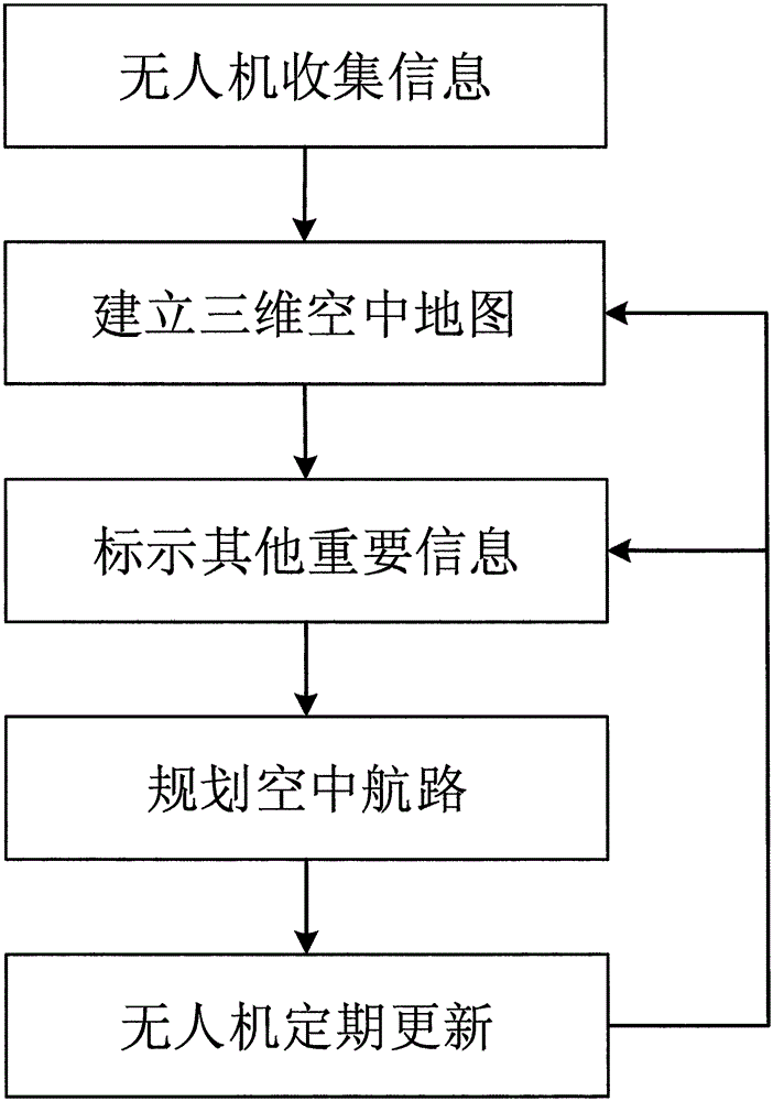
[0020] figure 1 It is the process of establishing three-dimensional air route map. Such as figure 1 As shown, the method includes the following steps:

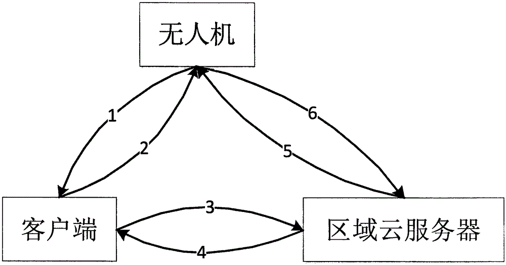
[0021] 1. First release multiple drones equipped with direction sensors and cameras, and the operator will fly over the area where a three-dimensional air route map needs to be established, and take the depth pictures taken by the drones, as well as the recorded speed, direction, and gravity information sent to the server.

[0022] 2. On the server side, use the data sent by each UAV to create a corresponding three-dimensional air route map, and then stitch each three-dimensional map into an overall map of the entire area where the three-dimensional map needs to be created, and s...


PUM


Abstract

The invention discloses a three-dimensional aerial airway map of an unmanned aerial vehicle and a dynamic building method thereof. Through the unmanned aerial vehicle and based on an existing ground two-dimensional map, a three-dimensional aerial map of an area, which is needed for flight, is obtained; important information is marked on the map; an air route is designated in the three-dimensional aerial map; the three-dimensional aerial airway map is built and stored in a cloud server of the area; a user can download the data of the map by using a terminal, looks up the information, creates a flight mission, looks into the information of the unmanned aerial vehicle in real time, and meanwhile, periodically utilizes the information sent back by the unmanned aerial vehicle provided with a direction sensor and a camera to build a new three-dimensional map, to check a change which occurs on an airway and influences flight safety, and to update and maintain the map; meanwhile, the server can autonomously plan the airway and navigate for the unmanned aerial vehicle according to the real-time information and flight mission of the unmanned aerial vehicle in each area.

Description

technical field [0001] The invention relates to a construction of a three-dimensional aerial route map of an unmanned aerial vehicle and a route display method thereof, which are mainly applied to the autonomous navigation and air traffic management of the unmanned aerial vehicle. Background technique [0002] UAV is the abbreviation of unmanned aircraft (UnmannedAerialVehicle), which is an unmanned aircraft that uses radio remote control equipment and its own program control device, including unmanned helicopters, fixed-wing aircraft, multi-rotor aircraft, unmanned airships, man paraglider. From a certain point of view, UAVs can complete complex air flight tasks and various load tasks under unmanned conditions, and can be regarded as "air robots". With the continuous advancement of automation and sensor technology, the manufacturing technology and performance of UAVs are developing rapidly. The applications of UAVs in military and civilian fields are increasing, and the ma...

Claims


Application Information

Patent Timeline
IPC IPC(8): G01C21/00G01C21/16
CPCG01C21/005G01C21/165
Inventor 徐利杰冯聪董朝阳
Owner SAIDU TECH BEIJING CO LTD
Why Eureka
Try Eureka