Map information processing method and terminal

An information processing method and terminal technology, applied in the field of communication, can solve the problems of too much information in navigation applications, no effective solution yet, interference with the user's vision, etc., and achieve the effect of less information.

Active Publication Date: 2016-06-01
TENCENT TECH (SHENZHEN) CO LTD +1
View PDF6 Cites 40 Cited by
  • Summary
  • Abstract
  • Description
  • Claims
  • Application Information

AI Technical Summary

Problems solved by technology

[0004] However, the problems of using the above-mentioned prior art include: 1) Too much information displayed on the navigation application (such as a map application) will interfere with the user's field of vision. In order to obtain useful information, the user needs to constantly pan, or zoom in or Zoom in on the map to get useful information (such as traffic information)
However, in related technologies, there is no effective solution to this problem

Method used


Image

  • Map information processing method and terminal
  • Map information processing method and terminal
  • Map information processing method and terminal

Examples


Embodiment 1

[0108] A method for processing map information in an embodiment of the present invention, such as Figure 7 As shown, the method includes:

[0109] Step 101, acquire attribute information of a terminal user.

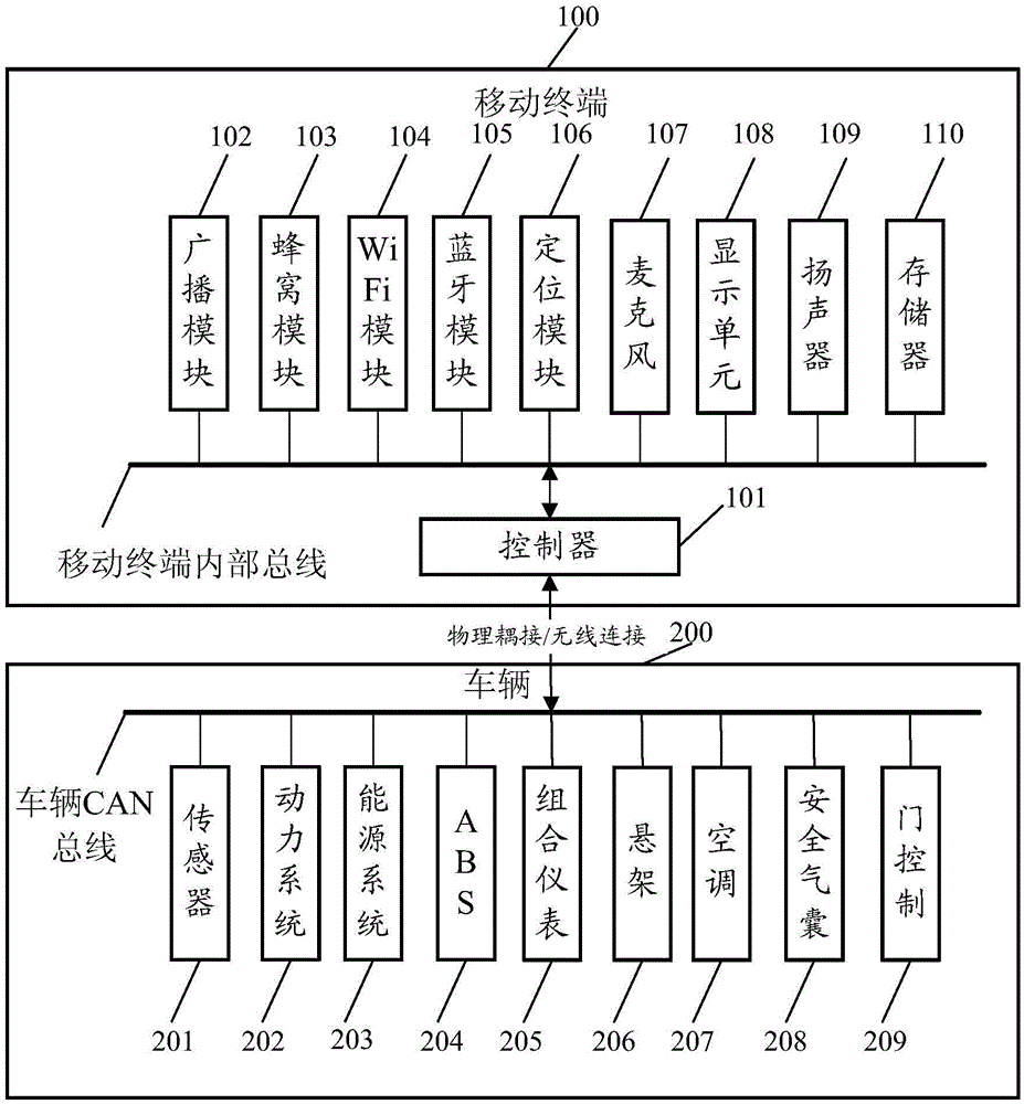
[0110] Here, taking the car navigation as an example, after the terminal starts the navigation application, the attribute information of the terminal user can be acquired.

[0111] Here, take a user's habitual driving plan as an example. After the terminal starts the navigation application, obtain the terminal user's attribute information (such as when the map application is started, when to start, the terminal's current location information, etc.) , for matching with the local navigation-related information database of the terminal; or, after the terminal starts the navigation application, report the attribute information of the terminal user, and send it to the server for matching with the local navigation-related information database of the server. The server receiv...

Embodiment 2

[0123] A method for processing map information in an embodiment of the present invention, such as Figure 10 As shown, the method includes:

[0124] Step 201, when the terminal starts (for example, when the navigation application is installed, the terminal starts the navigation application), obtain the time information and / or date information triggered when the terminal starts the navigation application, and store the time information and / or date information Determined as the attribute information of the terminal user.

[0125] Here, in addition to the time information and / or date information, it is also possible to further acquire the current self-position information obtained according to the GPS positioning of the global satellite positioning system when the terminal starts the navigation application, and use the time information and / or date information, current self-position information, The time information and / or date information and the current self-location informatio...

Embodiment 3

[0151] A terminal according to an embodiment of the present invention, such as Figure 11 As shown, the terminal includes: an attribute acquiring unit 11, configured to acquire attribute information of a terminal user; and a route acquiring unit 12, configured to acquire at least one route based on the attribute information of the terminal user, the route including the The user's habitual driving route, the route is obtained by matching the terminal user's attribute information and user history data (for example, the terminal user's attribute information can be combined with a navigation-related information database generated based on the user's habitual driving navigation history data matching, if the matching is successful, the display unit is turned on); and the display unit 13 is used to display the at least one route in the first area, and the at least one route is more prominently displayed in the first area than other information, The at least one route is distinguished b...


PUM


Abstract

The invention discloses a map information processing method and a terminal. The method comprises the steps that attribute information of a user of the terminal is obtained; based on the attribute information of the user of the terminal, at least one path is obtained, wherein the paths comprise the common driving path of the user and are obtained by matching the attribute information of the user of the terminal with historical data of the user; the paths are displayed in a first region and are highlighted compared with other information in the first region, and the paths are distinguished with different pieces of identification information.

Description

technical field [0001] The invention relates to communication technology, in particular to a map information processing method and a terminal. Background technique [0002] Using maps, you can plan routes, navigate, locate locations, and more. In one application scenario, with the popularization of car navigation, the daily life of users is facilitated and the travel needs of users are met. Vehicle navigation can be realized through a navigation application installed on the vehicle system, or through a navigation application installed on a terminal such as a mobile phone. The navigation application can be pre-installed by the system, or installed by the user, and so on. Specifically, the travel route can be simulated according to the addresses of the origin and destination input by the user, and the actual driving trajectory of the user can be located. Moreover, these data can be stored as historical data for data analysis. [0003] In the actual application of vehicle na...

Claims


Application Information

Patent Timeline
Patent Type & Authority Applications(China)
IPC IPC(8): G01C21/34
CPCG01C21/3415G01C21/343
Inventor 臧苏宇孙立光王刚伟刘燕妮彭大静
Owner TENCENT TECH (SHENZHEN) CO LTD
Why Eureka
Try Eureka