Matching method of gravity-aided inertial navigation system

A technology of an inertial navigation system and a matching method, which is applied in the field of gravity-assisted inertial navigation system matching, can solve problems such as poor real-time performance, and achieve the effects of reducing the number, improving the search efficiency, and improving the matching efficiency.

Active Publication Date: 2016-06-29
BEIJING INSTITUTE OF TECHNOLOGYGY
View PDF6 Cites 18 Cited by
  • Summary
  • Abstract
  • Description
  • Claims
  • Application Information

AI Technical Summary

Problems solved by technology

[0005] In view of this, the purpose of the present invention is to provide a gravity-assisted inertial navigation system matching method to solve the problem of poor real-time performance of traditional sequence matching algorithms

Method used


Image

  • Matching method of gravity-aided inertial navigation system
  • Matching method of gravity-aided inertial navigation system
  • Matching method of gravity-aided inertial navigation system

Examples


Embodiment

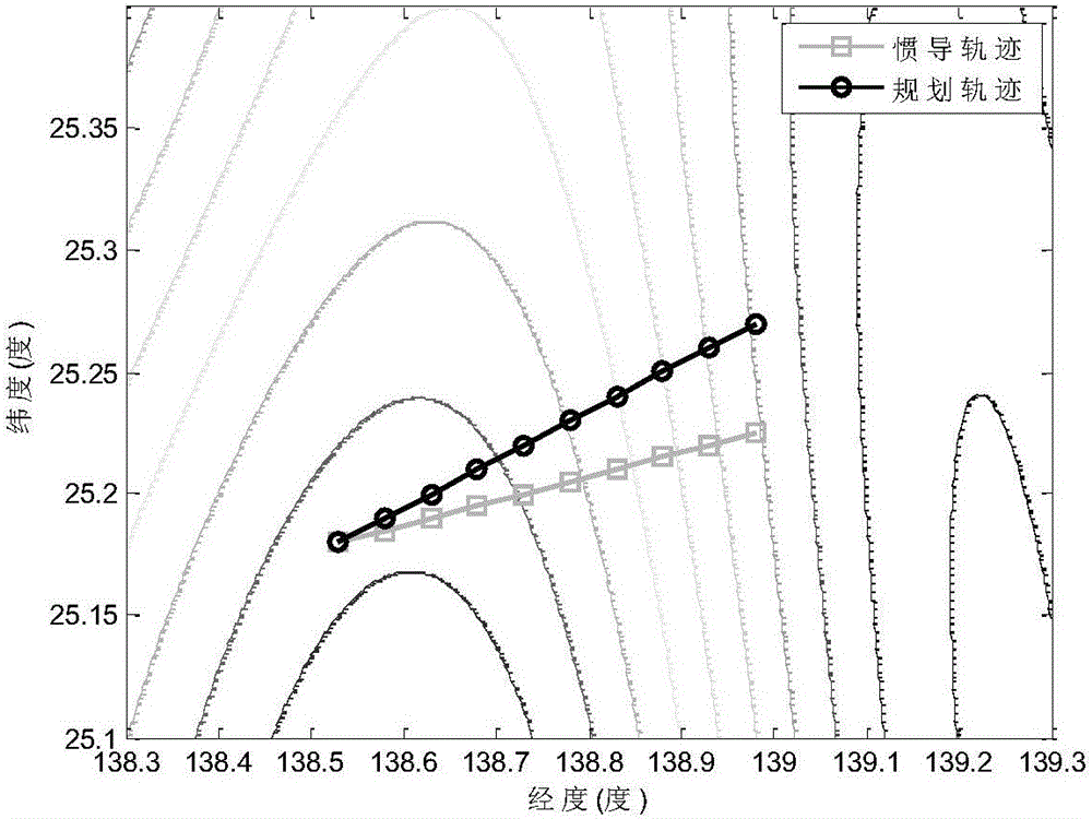
[0051] In this embodiment, the simulation conditions are: the longitude interval of the matching area is 138.3-139.3 degrees, the latitude interval is 25.1-25.4 degrees; the resolution of the gravity map is 0.5'×0.5'; a set of sequences takes 10 points. Gravity field background map (including planned track and inertial navigation track) such as figure 2 shown.

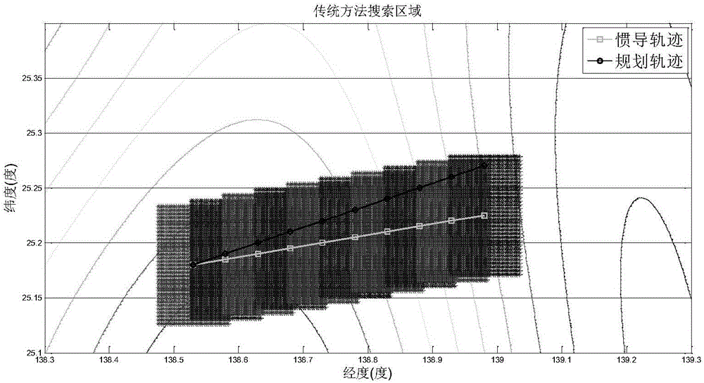
[0052] The search area determined by the traditional method (fixed search area) is as follows: image 3 , using the method of the present invention (variable search area) such as Figure 4 , it can be seen that the search range is effectively reduced. Figure 4 compared to image 3 , the total number of candidate matching trajectory points in the search area is changed from 10 4 Effectively reduced to 10 3 indivual.

[0053] After limiting the search area, use |g i (x i ,y i )-g i (x k ,y k )|=Δg i ≤δ to select the corresponding approximate gravity equivalent point, such as Figure 5 shown. The selectio...


PUM


Abstract

The invention discloses a matching method of a gravity-aided inertial navigation system. The manner that search regions can be changed is adopted, the search regions change in real time along with changes of inertial navigation precision, the searching range is effectively reduced, the number of alternative matched track points is reduced, and the searching efficiency is improved; the alternative matched track points are further screened by looking for points approaching a gravity abnormal value measured by a gravity meter in each search region; the number of the alternative matched tracks is effectively reduced under the constraint condition that the distance between each matched tracking point and the corresponding inertial navigation output track point deviates increasingly and changes in a certain range, and the matching efficiency is improved.

Description

technical field [0001] The invention belongs to the technical field of integrated navigation, and relates to a matching method of a gravity-assisted inertial navigation system. Background technique [0002] As a big country with both land and sea, the marine strategy is becoming more and more important in my country's overall development strategy. my country is also paying more and more attention to the development of marine technology. Underwater submersible technology is indispensable in the development of marine technology. has very important strategic significance. The inertial navigation system is usually used as the main navigation system of underwater vehicles because of its characteristic that it can realize navigation only by itself. When the inertial navigation system works, it does not need to receive signals from the outside, nor does it need to transmit signals to the outside. It has the advantages of high concealment, passive autonomy, etc. However, as an inte...

Claims


Application Information

Patent Timeline
Patent Type & Authority Applications(China)
IPC IPC(8): G01C21/16
CPCG01C21/16
Inventor 邓志红卢文典付梦印王博肖烜刘彤
Owner BEIJING INSTITUTE OF TECHNOLOGYGY
Why Eureka
Try Eureka