
Multi-agent and ant colony algorithm-based object-oriented remote sensing classification method

An ant colony algorithm, object-oriented technology, applied in computing, computer components, character and pattern recognition, etc., to achieve the effect of improving accuracy

Inactive Publication Date: 2016-07-06
WUHAN UNIV OF TECH
View PDF6 Cites 3 Cited by
  • Summary
  • Abstract
  • Description
  • Claims
  • Application Information

AI Technical Summary

Problems solved by technology

However, because the ant colony algorithm needs to set many parameters, its results have a certain degree of randomness and tendency, and can only reflect the impact of a certain type of specific object on land use change.

Method used


Image

  • Multi-agent and ant colony algorithm-based object-oriented remote sensing classification method
  • Multi-agent and ant colony algorithm-based object-oriented remote sensing classification method
  • Multi-agent and ant colony algorithm-based object-oriented remote sensing classification method

Examples


Embodiment Construction

[0027] The present invention will be further described below in conjunction with specific examples and accompanying drawings.

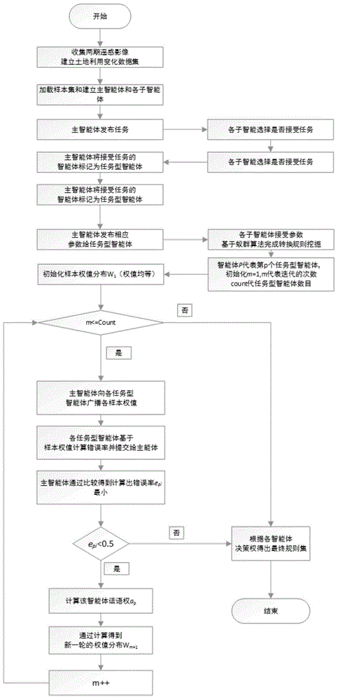
[0028] The invention provides an object-oriented remote sensing classification method based on multi-agent and ant colony algorithm, such as figure 1 As shown, it includes the following steps:

[0029] S1. Construction of sample data sets: collect remote sensing image data of at least two phases of the study area, and conduct data vectorization based on the remote sensing image data, produce urban land use classification data, and construct land use change sample data sets.

[0030] S2. Initialize the main agent and the sub-agent, and the main agent releases the task of mining land use change transformation rules.

[0031] S3. Several sub-agents choose whether to accept the task of the main agent according to their own capabilities, and return corresponding messages to the main agent. Among them, the main consideration of its own ability is whether ...


PUM


Abstract

The invention provides a multi-agent and ant colony algorithm-based object-oriented remote sensing classification method. The method comprises the steps that a sample data set is constructed; a main agent releases a task of mining land use conversion rules; a plurality of sub-agents receive the task of the main agent to become task type agents, and complete the mining of the land use conversion rules by adopting an ant colony algorithm by utilizing the land use conversion sample data set to obtain land conversion prediction types; and the main agent receives a completion message of each task type agent, performs multi-agent based negotiation and finally selects one prediction type as a final prediction type. According to the method, the multiple agents and the ant colony algorithm are combined; the randomness of a plurality of single ant colonies is subjected to weighted combination based on a method for continuously adjusting sample weights according to a sample set and a preset rule set; and a multi-agent negotiating and decision-making process is quantitatively expressed, so that the precision of final land conversion prediction is improved.

Description

technical field [0001] The invention relates to the field of remote sensing image classification, in particular to an object-oriented remote sensing classification method based on multi-agent and ant colony algorithm. Background technique [0002] In recent years, under the development trend of smart cities, the public has increasingly urgent requirements for the scientific and efficient allocation of land resources. Using spatial data mining technology to mine land resource data information. As a classic data mining algorithm, ant colony algorithm can effectively mine the rules of urban land use change based on the idea of ​​"local learning, overall integration". However, due to the need to set many parameters, the results of ant colony algorithm have certain randomness and tendency, and can only reflect the impact of a certain type of specific object on land use change. Contents of the invention [0003] The technical problem to be solved by the present invention is to ...

Claims


Application Information

Patent Timeline
Patent Type & Authority Applications(China)
IPC IPC(8): G06F17/30G06K9/62
CPCG06F16/2465G06F18/24
Inventor 崔巍郑振东周琪
Owner WUHAN UNIV OF TECH
Learn More