A method for judging the risk of rock landslides and its application
A technology based on risk and rock quality, which is applied in the field of risk judgment of rock landslides, can solve problems such as reduced accuracy of landslide early warning, lack of quantitative topographic factor calculation methods, and unsuitable for rock landslide risk judgment, achieving reduction Landslide hazards, improving the effect of landslide early warning, and the effect of strong applicability
- Summary
- Abstract
- Description
- Claims
- Application Information
AI Technical Summary
Problems solved by technology
Method used
Image
Examples
Embodiment 1
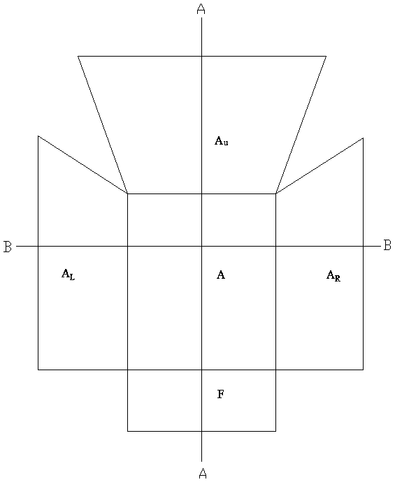
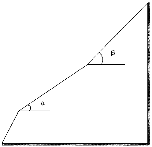
[0035] see Figure 1-Figure 3 , a method for judging the risk of rock landslides, comprising the following steps:
[0036] a. Determine the basic topographical data of the landslide through on-site investigation and mapping: the slope of the landslide α, the area of the landslide A, and the area of the upper side of the landslide A u, the slope of the upper side of the landslide body β, the area of the left side of the landslide body A L , the topographic undulation slope on the left side of the landslide body θ 1 , the area A of the right side of the landslide body R , the terrain undulation slope on the right side of the landslide body θ 2 ;
[0037] b. Calculate the upper steep terrain factor U through formula 1, and calculate the comprehensive factor C on both sides through formula 2;
[0038]
[0039]
[0040] c. Calculate the terrain comprehensive discriminant factor T by formula 3;
[0041] T=tan(α)+1.5U+0.5C (Formula 3)
[0042] D, the landslide comp...
Embodiment 2
[0045] see Figure 1-Figure 3 , a method for judging the risk of rock landslides, comprising the following steps:
[0046] a. Determine the basic topographical data of the landslide through on-site investigation and mapping: the slope of the landslide α, the area of the landslide A, and the area of the upper side of the landslide A u , the slope of the upper side of the landslide body β, the area of the left side of the landslide body A L , the topographic undulation slope on the left side of the landslide body θ 1 , the area A of the right side of the landslide body R , the terrain undulation slope on the right side of the landslide body θ 2 ;
[0047] b. Calculate the upper steep terrain factor U through formula 1, and calculate the comprehensive factor C on both sides through formula 2;
[0048]
[0049]
[0050] c. Calculate the terrain comprehensive discriminant factor T by formula 3;
[0051] T=tan(α)+1.5U+0.5C (Formula 3)
[0052] D, the landslide com...
Embodiment 3
[0056] see Figure 1-Figure 3 , a method for judging the risk of rock landslides, comprising the following steps:
[0057] a. Determine the basic topographical data of the landslide through on-site investigation and mapping: the slope of the landslide α, the area of the landslide A, and the area of the upper side of the landslide A u , the slope of the upper side of the landslide body β, the area of the left side of the landslide body A L , the topographic undulation slope on the left side of the landslide body θ 1 , the area A of the right side of the landslide body R , the terrain undulation slope on the right side of the landslide body θ 2 ;
[0058] b. Calculate the upper steep terrain factor U through formula 1, and calculate the comprehensive factor C on both sides through formula 2;
[0059]
[0060]
[0061] c. Calculate the terrain comprehensive discriminant factor T by formula 3;
[0062] T=tan(α)+1.5U+0.5C (Formula 3)
[0063] D, the landslide com...
PUM
 Abstract
Description
Claims
Application Information
 - R&D
- Intellectual Property
- Life Sciences
- Materials
- Tech Scout
- Unparalleled Data Quality
- Higher Quality Content
- 60% Fewer Hallucinations
Browse by: Latest US Patents, China's latest patents, Technical Efficacy Thesaurus, Application Domain, Technology Topic, Popular Technical Reports.
© 2025 PatSnap. All rights reserved.Legal|Privacy policy|Modern Slavery Act Transparency Statement|Sitemap|About US| Contact US: help@patsnap.com


