Ship mooring assisting method and ship mooring assisting system

一种船舶、泊岸的技术,应用在准确监控船舶与岸线距离以及船舶姿态领域,能够解决无法安全地保证船舶雾天精确定位靠泊引航、难得到船体、数据误差等问题

Active Publication Date: 2016-08-10
NANJING UNIV 5D TECH
View PDF4 Cites 7 Cited by
  • Summary
  • Abstract
  • Description
  • Claims
  • Application Information

AI Technical Summary

Problems solved by technology

For example, when using a three-axis electronic compass, sometimes it is subject to huge magnetic field interference, which makes the data obtained have errors, and it is difficult to obtain a more accurate distance between the hull and the berthing shoreline, making berthing still difficult
[0011] Therefore, the current existing technology cannot ensure the precise positioning, berthing and piloting of ships in foggy weather conveniently, accurately and safely.

Method used


Image

  • Ship mooring assisting method and ship mooring assisting system
  • Ship mooring assisting method and ship mooring assisting system
  • Ship mooring assisting method and ship mooring assisting system

Examples


Embodiment 1

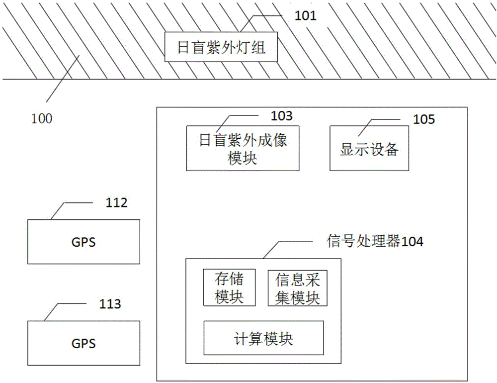
[0094] For the system block diagram of ship berthing navigation see figure 1 As shown, the present invention mainly solves the problem when ships berth in foggy weather at close range. The ship navigation system described in this embodiment includes a sun-blind ultraviolet lamp group 101, two GPS modules 112 and 113, a sun-blind ultraviolet imaging module 103, data A processing module 104 and a display device 105 .

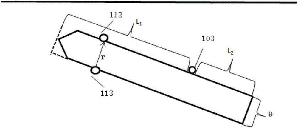
[0095] The GPS modules 112, 113 and the sun-blind ultraviolet imaging module 103 are respectively installed on the ship. The installation positions of the differential GPS 112 and 113 are the most convenient for determining the heading. In this embodiment, two differential GPSs are respectively installed on the decks on both sides of the cab, and the connection between the two can be roughly perpendicular to the connection between the bow and tail of the ship. Two differential GPS modules, a master GPS module (also called a master station) 112 are installed near...

Embodiment 2

[0134] This embodiment is about how to obtain optimal position information in multiple sets of data, and its algorithm is as follows:

[0135] use the vector p i (x i ,y i ,z i ) represents N sets of angle and space transformed positioning data returned by N systems, where i=1, 2, 3...N. The positioning data after the angle and space transformation are obtained by using the spatial position relationship and spatial geometric transformation when the relative positions and ship attitude angles of all solar-blind ultraviolet receiving modules and GPS signal receiving modules are known. , converting the position measurement data of different measurement modules into the position measurement data of the same measurement module. The specific transformation method is:

[0136] (1) determine a reference point, the reference point can be the location of any measurement module in the sun-blind ultraviolet receiving module and the GPS signal receiving module, and can also be other c...

Embodiment 3

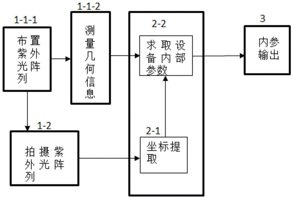
[0153] In the following example, the specific steps for calibrating the ultraviolet camera and solving the internal parameters in a system for enhancing the short-distance navigation capability of the ship according to the present invention are given:

[0154] There are many methods for camera calibration and algorithms for solving internal parameters. Here, traditional calibration techniques and Zhang Zhengyou calibration algorithms are preferred. Zhang Zhengyou’s calibration method uses a checkerboard-shaped calibration template, and the connection points of each black and white square on the calibration template are used as the feature points of the calibration board. The calibration board is placed in different positions, and the internal and external parameters of the camera are obtained after synchronous acquisition by the camera. This method has good robustness, does not need expensive instruments and equipment, and is easy to operate. Compared with the self-calibration...


PUM


Abstract

The invention provides a ship mooring assisting method and a ship mooring assisting system. The method is characterized in that the position information of a ship relative to a berth is determined by use of a solar blind ultraviolet imaging method, and the attitude angle of the ship relative to the berth is determined by at least two GPS receivers through a GPS method, so the problem on how to moor a ship safely when the ship is close to the shore under the condition of low visibility is solved effectively. Further, according to the method and the device of the invention, a normalized autocorrelation algorithm and a data fusion algorithm can be preferably adopted to integrate coordinate data and angle data received by a solar blind ultraviolet imaging module and a GPS signal receiving module in order to improve the positioning accuracy. By using the ship mooring assisting method and the ship mooring assisting system of the invention, the problem that it is very difficult to moor a ship in fog in the prior art and the problem that the ship piloting and berthing device in the prior art is largely affected by the weather and environment are solved obviously.

Description

technical field [0001] The invention relates to a method and a device for safe navigation of a ship. More specifically, the present invention relates to a method and a device for accurately monitoring the distance between the ship and the shoreline and the attitude of the ship during the berthing process of the ship. Background technique [0002] The safe berthing of ships is a difficult problem that has been focused on in the field of water transportation. During the process of berthing at the port, the ship needs to strictly control the berthing speed and distance, and also need to refer to the attitude of the ship. The pilot must be well aware of the geographical characteristics, channel, water depth, current, navigation mark setting and local regulations of the water area where he is located, and he must be proficient in maneuvering techniques that are difficult to approach and leave the pier. Therefore, the pilot not only has a very high work intensity, but also bears...

Claims


Application Information

Patent Timeline
Patent Type & Authority Applications(China)
IPC IPC(8): G01S19/53G01S19/48
CPCG08G3/02G08G3/00B63H2025/045B63B2213/02G06T7/50G06T7/73G01S19/13G01S19/53G06T2207/20024G06T2207/30252
Inventor 朱曦李媛媛闫锋李想曹汛潘巍松丁健文王继斌王军陈辰李大鹏李伟王文伫
Owner NANJING UNIV 5D TECH
Why Eureka
Try Eureka