A method and system for calculating the pose of a mobile robot based on lidar data

A mobile robot and laser radar technology, applied in control/regulation systems, two-dimensional position/channel control, instruments, etc., can solve problems such as integral error, accuracy impact, and large integral error, and achieve cost reduction and ease of implementation , the effect of improving reliability

Active Publication Date: 2018-09-11
重庆大学溧阳智慧城市研究院
View PDF3 Cites 0 Cited by
  • Summary
  • Abstract
  • Description
  • Claims
  • Application Information

AI Technical Summary

Problems solved by technology

In general, the accuracy of inertial navigation system is higher than that of dead reckoning, but its accuracy is also affected by gyroscope drift, calibration error, sensitivity and other issues
[0004] Both dead reckoning and inertial navigation systems have a common disadvantage: there is an integral error, and the farther the mobile robot travels, the greater the integral error
Therefore, the existing pose estimation methods are not suitable for occasions that require high robot pose information.

Method used


Image

  • A method and system for calculating the pose of a mobile robot based on lidar data
  • A method and system for calculating the pose of a mobile robot based on lidar data
  • A method and system for calculating the pose of a mobile robot based on lidar data

Examples


Embodiment 1

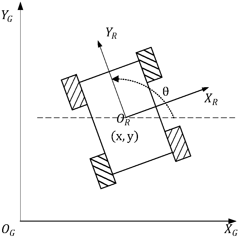
[0091] As shown in the figure, a method for calculating the pose of a mobile robot based on lidar data provided in this embodiment includes the following steps:

[0092] Step1: Receive and preprocess lidar data;

[0093] Step2: Segment and cluster environmental data;

[0094] Step3: Select clusters from lidar data;

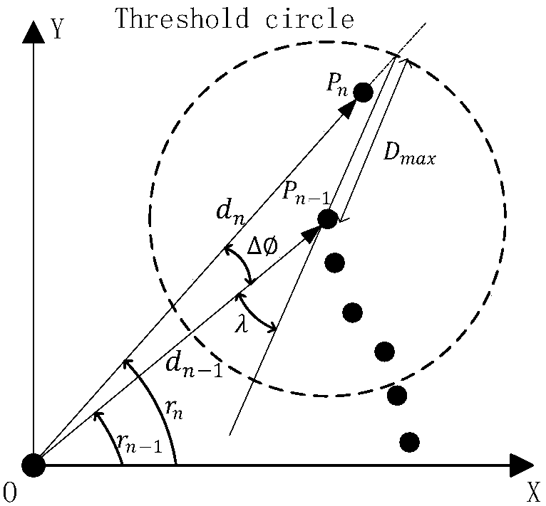
[0095] Step4: Tracking of the target cluster; obtain the coordinate data of the vertices of each sub-cluster in the cluster in the local coordinate system, obtain the coordinates of the vertices of the cluster and the inclination angle of each connecting line;

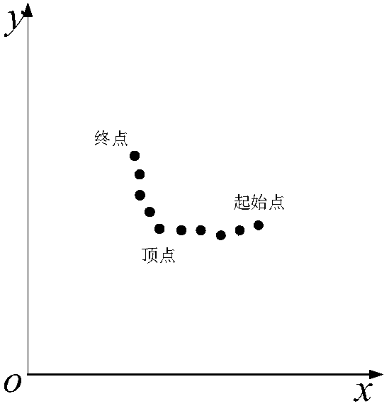
[0096] Step5: Form the starting point and the end point into a connecting line and calculate the deflection angle of the connecting line in the cluster;

[0097] Step6: Calculate the position coordinates of the robot after the position coordinates change through sliding filtering;

[0098] Step7: Initialize the pose of the starting point and store the position coordinates.

[0099] The specific steps o...

Embodiment 2

[0159] The method for estimating the pose of a mobile robot based on laser radar data provided in this embodiment, firstly, receives and preprocesses the laser radar data, as follows:

[0160] Connect the two-dimensional scanning laser radar sensor with the computer to obtain the environmental data, and store them in the computer in the form of an array. The environmental data is mainly represented by the distance information D={d 1 , d 2 , d 3 ,...,d i ,...,d N}. The distance data is then preprocessed, including removing data points outside the effective range, filtering out isolated noise points, and compensating for defects in the lidar measurement mechanism. In addition, the environmental data is converted from the data in the polar coordinate system of the lidar to the local rectangular coordinate system coordinates of the robot or intelligent vehicle, that is, the data set is expressed as: bg={P 1 ,P 2 ,P 3 ,...,P i ,...P N}, where P i Expressed as the informat...

Embodiment 3

[0209] This embodiment describes in detail the implementation of the mobile robot pose estimation method based on lidar data, which specifically includes the following steps:

[0210] Step1: Lidar data reception and preprocessing

[0211] Connect the two-dimensional scanning laser radar sensor with the computer to obtain the environmental data, and store them in the computer in the form of an array. The environmental data is mainly represented by the distance information D={d 1 , d 2 , d 3 ,...,d i ,...,d N}, N usually takes a value of 500, corresponding to the scanning range of the lidar 180°, and the angular resolution ξ=0.36°. The distance data is then preprocessed, including removing data points outside the effective range, filtering out isolated noise points, and compensating for defects in the lidar measurement mechanism. In addition, the environmental data is converted from the data in the polar coordinate system of the lidar to the local rectangular coordinate sys...


PUM


Abstract

The invention discloses a mobile robot posture reckoning method based on laser radar data. The method comprises the following steps: first of all, receiving and preprocessing the laser radar data; segmenting cluster environment data; then, selecting a cluster from the laser radar data; tracking an object cluster; obtaining coordinate data of the summit of each sub cluster in the cluster under a local coordinate system, and obtaining coordinates of the summit of the cluster and an inclined angle of each connection line; forming a connection straight line from a start point and a terminal point, and calculating a deflection angle; through slide filtering, calculating position coordinates after robot position coordinates are changed; and finally, initializing a posture of the start point and a sampling posture point. According to the mobile robot posture reckoning method provided by the invention, a two-dimensional laser radar with quit high precision is used, and environment does not have to be modified at all; and posture information of a robot is objectively described relative to a concrete environment, the posture information can be more conveniently integrated to service modules of other mobile robots, the system reliability and the easy realization property are improved, and the cost is decreased.

Description

technical field [0001] The invention relates to the field of local navigation of mobile robots and intelligent vehicles, in particular to a method for estimating the pose of a mobile robot based on laser radar data. Background technique [0002] As a new type of production tool, robots show great advantages. In terms of reducing labor intensity, improving production efficiency, and changing production modes, it can liberate people from dangerous, harsh, and heavy working environments. However, with the continuous development of robots, people have gradually found that these robots that operate at a certain position cannot meet the requirements of many applications. Therefore, in the late 1980s, many countries began to carry out research on mobile robot technology in a planned way. [0003] For mobile robots, navigation is an important direction. The premise of the navigation of the mobile robot is the positioning and gesture recognition of the robot. Accurate pose estima...

Claims


Application Information

Patent Timeline
Patent Type & Authority Patents(China)
IPC IPC(8): G05D1/02
CPCG05D1/0257
Inventor 孙棣华赵敏廖孝勇程森林杜道轶
Owner 重庆大学溧阳智慧城市研究院
Why Eureka
Try Eureka