Unmanned aerial vehicle air docking method and system

A kind of aerial docking, the first unmanned aerial vehicle technology, applied in the direction of control/adjustment system, non-electric variable control, instrument, etc., can solve the problems such as the inability to achieve accurate docking, limited precision of GPS module, and difficulty of unmanned aerial vehicles, etc. To achieve the effect of convenient docking or separation and improved accuracy

Inactive Publication Date: 2016-08-17
SHENZHEN HIGHGREAT TECH DEV CO LTD
View PDF5 Cites 18 Cited by
  • Summary
  • Abstract
  • Description
  • Claims
  • Application Information

AI Technical Summary

Problems solved by technology

[0002] At present, drones used for binocular vision generally require a relatively wide body. In order to measure farther depths, a larger distance between the two cameras in binocular vision is required. However, it is difficult for such drones to pass through narrower areas. The place
[0003] In the prior art, the GPS module is used for positioning to realize the docking of two UAVs in the air. However, the accuracy of the GPS module is limited and the precise docking cannot be realized. Therefore, a method for accurately docking two UAVs in the air is needed and system

Method used


Image

  • Unmanned aerial vehicle air docking method and system

Examples


Embodiment 1

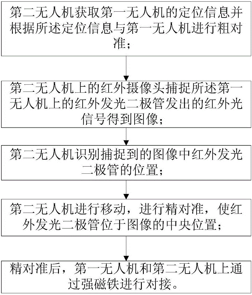
[0047] Please refer to figure 1 , Embodiment 1 of the present invention is:

[0048] A kind of unmanned aerial vehicle docking method provided by the present invention comprises:

[0049] The second UAV acquires the positioning information of the first UAV and performs rough alignment with the first UAV according to the positioning information;

[0050] The infrared camera on the second drone captures the infrared light signal sent by the infrared light-emitting diode on the first drone to obtain an image;

[0051] The second UAV identifies the position of the infrared light emitting diode in the captured image;

[0052] The second UAV moves and performs fine alignment so that the infrared light-emitting diode is located in the center of the image;

[0053] After fine alignment, the first drone and the second drone are docked with strong magnets.

[0054] The specific implementation is as follows:

[0055] 1. The two UAVs are in the shape of "I". The head of the UAV is eq...


PUM


Abstract

The invention relates to the field of unmanned aerial vehicles, and particularly relates to an unmanned aerial vehicle air docking method and system. The method concretely comprises the steps that a second unmanned aerial vehicle can acquire positioning information of a first unmanned aerial vehicle through a GPS module arranged on the first unmanned aerial vehicle, and coarse alignment of the second unmanned aerial vehicle and the first unmanned aerial vehicle can be realized through the positioning information; the GPS module has limited accuracy and cannot realize accurate alignment so that infrared cameras are arranged on the second unmanned aerial vehicle; infrared light-emitting didoes are arranged on the first unmanned aerial vehicle, and accurate alignment is realized through image recognition; and docking is performed through strong magnets after accurate alignment. The accuracy of air docking of the two unmanned aerial vehicles is enhanced through coarse alignment and accurate alignment, and docking or separating through the strong magnets is convenient.

Description

technical field [0001] The invention relates to the field of unmanned aerial vehicles, in particular to a method and system for aerial docking of unmanned aerial vehicles. Background technique [0002] At present, drones used for binocular vision generally require a relatively wide body. In order to measure farther depths, a larger distance between the two cameras in binocular vision is required. However, it is difficult for such drones to pass through narrower areas. The place. [0003] In the prior art, the GPS module is used for positioning to realize the docking of two UAVs in the air. However, the accuracy of the GPS module is limited and the precise docking cannot be realized. Therefore, a method for accurately docking two UAVs in the air is needed and system. Contents of the invention [0004] The technical problem to be solved by the present invention is to provide a method and system for accurately docking two drones in the air. [0005] In order to solve the p...

Claims


Application Information

Patent Timeline
Patent Type & Authority Applications(China)
IPC IPC(8): G05D1/10
CPCG05D1/101
Inventor 高建民
Owner SHENZHEN HIGHGREAT TECH DEV CO LTD
Why Eureka
Try Eureka