
Calculation method of urban road traffic congestion index based on bayonet data

A road traffic and congestion index technology, applied in the field of intelligent transportation, can solve problems such as poor applicability, poor accuracy, and weak flexibility

Active Publication Date: 2018-03-02
ENJOYOR COMPANY LIMITED
View PDF8 Cites 0 Cited by
  • Summary
  • Abstract
  • Description
  • Claims
  • Application Information

AI Technical Summary

Problems solved by technology

[0006] In order to overcome the deficiencies of poor accuracy, weak flexibility and poor applicability of existing traffic index detection methods, the present invention provides a checkpoint data-based Calculation method of urban road traffic congestion index

Method used


Image

  • Calculation method of urban road traffic congestion index based on bayonet data
  • Calculation method of urban road traffic congestion index based on bayonet data
  • Calculation method of urban road traffic congestion index based on bayonet data

Examples


Embodiment Construction

[0055] The present invention will be further described below in conjunction with the accompanying drawings.

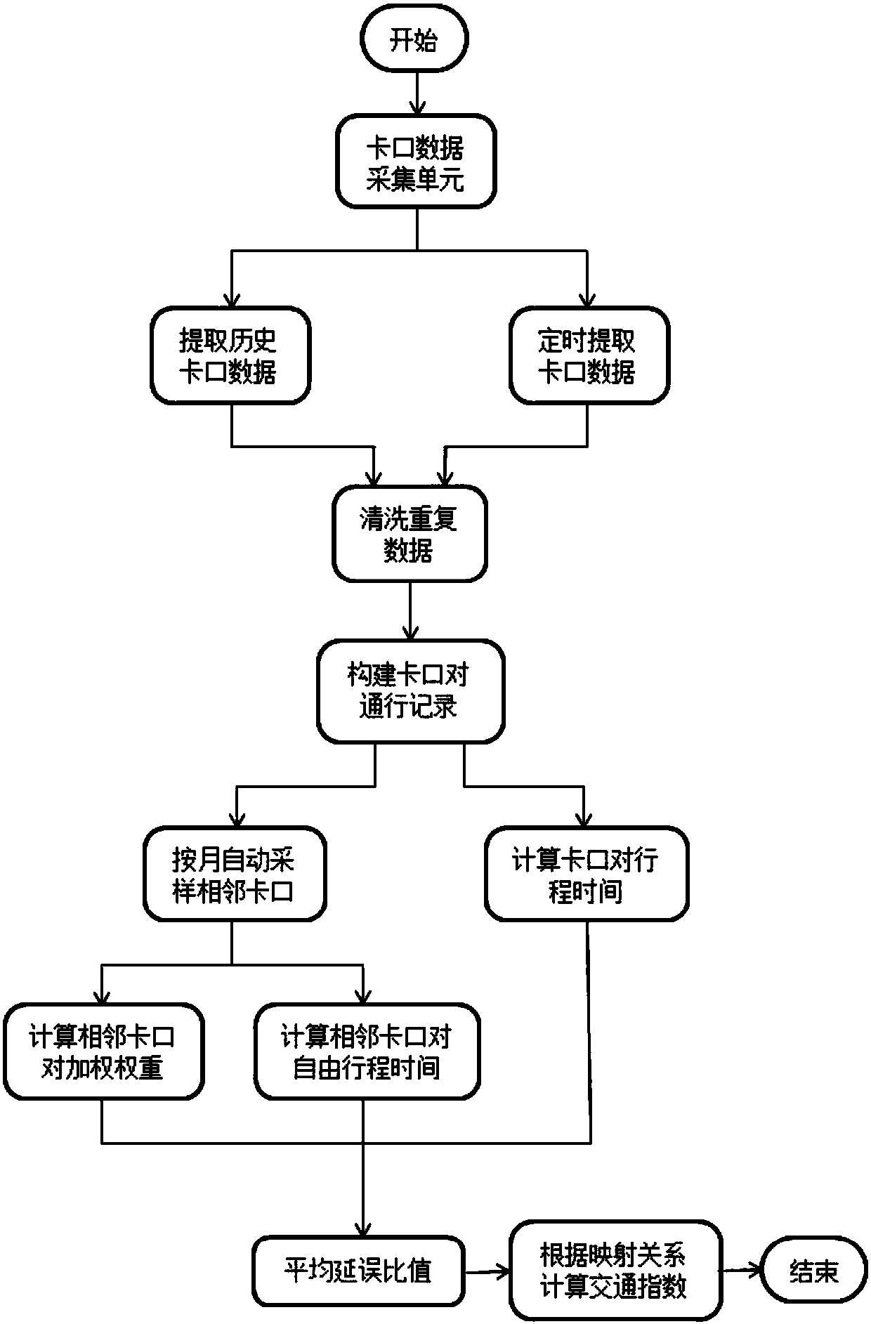
[0056] refer to figure 1 with figure 2 , a method for calculating urban road traffic congestion index based on checkpoint data, comprising the following steps:

[0057] Step 1: Extract historical bayonet data from the server database

[0058] Extract historical checkpoint data in December 2015 from the server database, automatically sample adjacent checkpoint pairs, calculate adjacent checkpoint pair free travel time and adjacent checkpoint pair road weights for calculating traffic congestion in January 2016 And other parameters, the above parameters are automatically updated based on the last month's bayonet data.

[0059] The bayonet data includes the following field information: KKID is the bayonet number, FXBH is the direction number, these two fields mark the specific location of the bayonet installation of the bayonet data, directly related to the spatial ge...


PUM


Abstract

An urban road traffic congestion index calculating method based on checkpoint data comprises steps as follows: step 1, acquiring the checkpoint data; step 2, cleaning the checkpoint data; step 3, building records of vehicle passage checkpoint pairs; step 4, automatically sampling the adjacent checkpoint pairs based on flow direction probability; step 5, calculating free travel time of the adjacent checkpoint pairs; step 6, building a weighting weight set q of road sections where the adjacent checkpoint pairs are located; step 7, acquiring the checkpoint data at regular time according to the statistical cycle; step 8, calculating traffic indexes in the statistical cycle. The urban road traffic congestion index calculating method based on the checkpoint data is better in accuracy, good in flexibility and higher in applicability.

Description

technical field [0001] The invention relates to the field of intelligent transportation, in particular to a calculation method for urban road traffic congestion index based on checkpoint data. Background technique [0002] With the improvement of my country's comprehensive strength and national income level, the number of motor vehicles increases rapidly at a rate of 20% to 30% per year, while the growth of urban roads is limited and slow, resulting in increasing urban traffic congestion and a significant decline in vehicle transportation efficiency. It has had a huge impact on how people live and work. In order to facilitate the traffic authorities to analyze the state and causes of road traffic congestion, comprehensively grasp the characteristics of traffic operation status, and reasonably guide the public to objectively and correctly understand the traffic operation situation, it is necessary to establish scientific and objective road traffic operation evaluation indicato...

Claims


Application Information

Patent Timeline
Patent Type & Authority Patents(China)
IPC IPC(8): G08G1/01
CPCG08G1/0125G08G1/0129G08G1/0133
Inventor 李建元张云云蒋伶华陈涛李丹
Owner ENJOYOR COMPANY LIMITED
Learn More