Determination method and system for road feasible region

A definite method and a feasible technology, applied in the field of radar scanning detection and environmental perception, can solve the problems of not being able to distinguish between roadside obstacles and roadsides, 64-line laser radar is expensive and costly

Active Publication Date: 2016-08-31
BEIJING INFORMATION SCI & TECH UNIV
View PDF7 Cites 4 Cited by
  • Summary
  • Abstract
  • Description
  • Claims
  • Application Information

AI Technical Summary

Problems solved by technology

For example, Nanjing University of Science and Technology proposed a road surface extraction algorithm suitable for structured and semi-structured road environments by using 64-line lidar. This algorithm uses fuzzy clustering to extract the road surface, and compares the radar data of several consecutive frames to determine The reference plane of the normal road surface can further extract the obstacles on the road surface, but the 64-line laser radar used in this method is expensive and the cost is too high
Wan Zhongtao improved the road detection algorithm by using the plane model of lidar and the extended Kalman filter algorithm, and completed the classification of single-frame radar data, but this classification cannot distinguish roadside obstacles from roadside

Method used


Image

  • Determination method and system for road feasible region
  • Determination method and system for road feasible region

Examples


Embodiment Construction

[0046] The following will clearly and completely describe the technical solutions in the embodiments of the present invention with reference to the accompanying drawings in the embodiments of the present invention. Obviously, the described embodiments are only some, not all, embodiments of the present invention. Based on the embodiments of the present invention, all other embodiments obtained by persons of ordinary skill in the art without making creative efforts belong to the protection scope of the present invention.

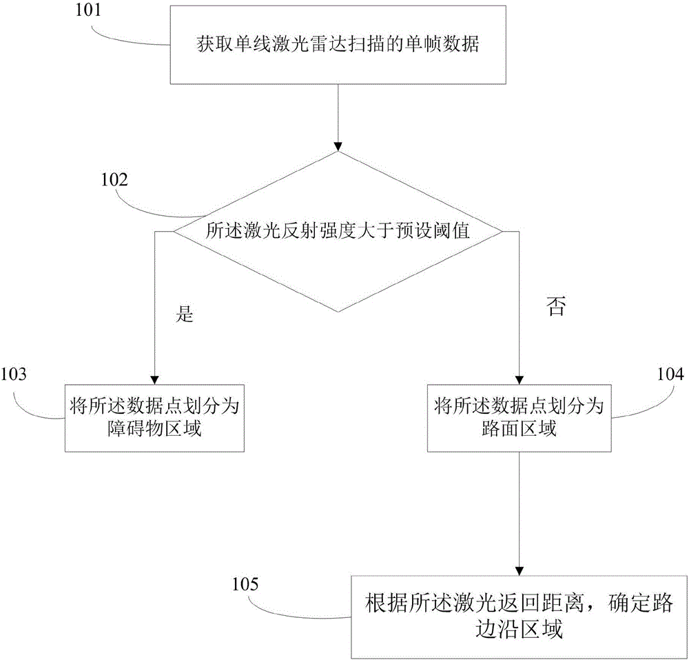
[0047] The purpose of the present invention is to provide a method for determining the feasible region of the road, such as figure 1 The above is a flow chart of the method for determining the feasible region of the road in this application, specifically as follows:

[0048] Step 101: Obtain a single frame of data scanned by a single-line lidar, the single-frame data includes a plurality of single-frame data points, and the single-frame data points include las...


PUM


Abstract

The invention discloses a determination method and system for a road feasible region. Single-frame data scanned by a single-line laser radar are obtained, wherein the single-frame data include a plurality of single-frame data points including laser reflection strength and laser returning distances; whether the laser reflection strength is higher than a preset threshold value is determined to obtain a first determination result; when the first determination result shows that the laser reflection strength is higher than the preset threshold value, the data points are divided as obstacle areas; and otherwise, the data points are divided as road surface areas; and according to laser returning distances, road edge areas are determined. According to the invention, on the basis of a hop characteristic of a road edge and a threshold condition of a laser reflection strength value, information including a road edge and a carrier feasible region is obtained by screening, so that the divided feasible region becomes accurate and stable. Therefore, improvement of the road edge extraction and road feasible region algorithm is realized. A little radar data information is needed; the calculation load is small; and the cost can be reduced.

Description

technical field [0001] The invention belongs to the field of radar scanning detection environment perception, in particular to a feasible domain division method for traversing laser radar reflection intensity and laser return distance. Background technique [0002] The identification of the feasible region of the road is a key part of unmanned vehicle driving and the movement of intelligent robots. At present, a lot of research has been done on the identification of the feasible region of the road in the system of unmanned vehicles and intelligent robots. The recognition methods mainly include the identification of the road feasible area using stereo vision, the identification of the road feasible area using lidar, and the identification of the road feasible area using multi-sensor fusion. [0003] Compared with other detection methods, the recognition of the feasible region of the road using lidar can obtain relatively high-precision surrounding environment related informat...

Claims


Application Information

Patent Timeline
Patent Type & Authority Applications(China)
IPC IPC(8): G01S15/93
CPCG01S15/93
Inventor 原鑫李擎张昊赵辉刘书平
Owner BEIJING INFORMATION SCI & TECH UNIV
Why Eureka
Try Eureka