Unmanned aerial vehicle mapping system of power transmission line

A technology of transmission lines and drones, which is applied in closed-circuit television systems, control/regulation systems, overhead lines/cable equipment, etc., to save equipment costs, reduce loads, and ensure flight safety.

Inactive Publication Date: 2016-11-09
STATE GRID SHANDONG ELECTRIC POWER +1
View PDF5 Cites 16 Cited by
  • Summary
  • Abstract
  • Description
  • Claims
  • Application Information

AI Technical Summary

Problems solved by technology

[0006] Aiming at the problem that the existing aircraft cannot meet the needs of long-distance remote control aerial photography of transmission lines, the present invention develops a UAV surveying and mapping system for transmission lines. The distance measurement is carried out for safety hazards such as tall trees and buildings, and its operation does not rely on wireless control, which facilitates the promotion of unmanned aerial vehicles in the field of transmission line inspection

Method used


Image

  • Unmanned aerial vehicle mapping system of power transmission line
  • Unmanned aerial vehicle mapping system of power transmission line
  • Unmanned aerial vehicle mapping system of power transmission line

Examples


Embodiment Construction

[0026] In order to better understand the present invention, the implementation manner of the present invention will be explained in detail below in conjunction with the accompanying drawings.

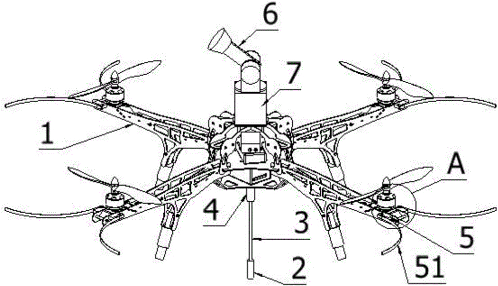
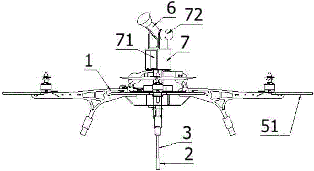
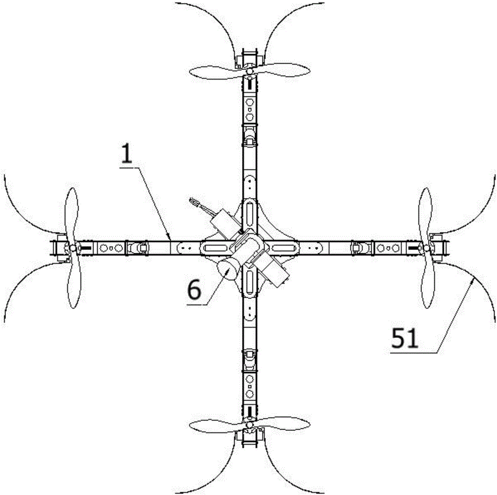
[0027] Figure 1 to Figure 4 It is an embodiment of the present invention, as shown in the figure, a power transmission line UAV surveying and mapping system includes a UAV 1, and a rangefinder 6, a camera, a wireless data module, and a GPS module are installed on the UAV 1 , controller, storage battery, rangefinder 6, the control port of the camera is connected to the command output port of the controller, and the data output port of the rangefinder 6, wireless data module, camera, and GPS module is connected to the data receiving port of the controller, and the controller The data output port of the wireless data module is connected to the data receiving port of the wireless data module. The console is provided with a module corresponding to the wireless data module. The drone 1 is al...


PUM


Abstract

The invention discloses an unmanned aerial vehicle surveying and mapping system for power transmission lines, including an unmanned aerial vehicle, on which a rangefinder, a camera, a wireless data module, a GPS module, a controller, a storage battery, a rangefinder, and a control port of a camera are installed. Connect the command output port of the controller, connect the data output port of the rangefinder, wireless data module, camera, and GPS module to the data receiving port of the controller, connect the data output port of the controller to the data receiving port of the wireless data module, and set the console There is a module corresponding to the wireless data module. There is also a digital magnetic field meter on the drone. The data output port of the digital magnetic field meter is connected to the data receiving port of the controller. The information is transmitted to the controller in digital form, and the controller controls the course and altitude of the UAV according to the strength of the magnetic field, so that the UAV can automatically patrol along the transmission line.

Description

technical field [0001] The invention relates to the technical field of transmission line maintenance equipment, in particular to an unmanned aerial vehicle surveying and mapping system for transmission lines. Background technique [0002] The safe operation of transmission lines is not only related to national production and life, but also related to the stable operation of the power system. Transmission line inspection work is an important and indispensable work to ensure safe and reliable power supply. During the operation of the transmission line, tall trees and buildings in the line protection area seriously threaten its operation safety. Accurate and convenient measurement of the distance between these obstacles and the wires can help the operation and maintenance personnel to effectively judge the danger level, formulate a reasonable pre-control plan, take protective measures in time, and greatly improve the safety level of the transmission line. Simply relying on th...

Claims


Application Information

Patent Timeline
Patent Type & Authority Applications(China)
IPC IPC(8): H02G1/02G05D1/10H04N7/18G01D21/02
CPCH02G1/02G01D21/02G05D1/101H04N7/18
Inventor 邵帅王凯杨杰张运成
Owner STATE GRID SHANDONG ELECTRIC POWER
Why Eureka
Try Eureka