Sea surface error correction method for measuring submarine topography on basis of airborne laser radar

An airborne laser radar and error correction technology, which is applied in measurement devices, radio wave measurement systems, and electromagnetic wave re-radiation. Effect

Active Publication Date: 2016-12-07
OCEANOGRAPHIC INSTR RES INST SHANDONG ACAD OF SCI
View PDF8 Cites 18 Cited by
  • Summary
  • Abstract
  • Description
  • Claims
  • Application Information

AI Technical Summary

Problems solved by technology

[0005] The present invention proposes a sea surface error correction method in order to solve the problem of poor accuracy of measurement results existing in the seabed topography measurement technology based on the design of the airborne laser radar system, and also uses the airborne

Method used


Image

  • Sea surface error correction method for measuring submarine topography on basis of airborne laser radar
  • Sea surface error correction method for measuring submarine topography on basis of airborne laser radar
  • Sea surface error correction method for measuring submarine topography on basis of airborne laser radar

Examples


Embodiment Construction

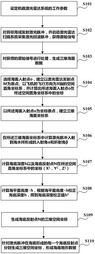
[0039] Specific embodiments of the present invention will be described in detail below in conjunction with the accompanying drawings.

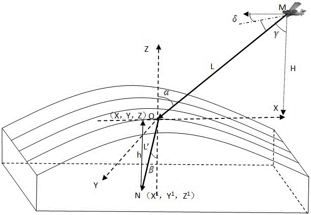
[0040] In this embodiment, in the process of using the airborne laser radar system to measure the seabed topography of the target sea area, the sea surface error correction technology is introduced, and the sea surface data grid is formed according to the laser echo pulses collected by the laser radar scanning system, and the three-dimensional sea surface data is established. ; Use each pulse point in the sea surface data grid as the sea surface incident point to form two curves intersecting at the incident point. According to the plane theorem, the tangent of the curved surface where the sea surface incident point is located can be determined by using the tangent of the two intersecting curves , the normal of the cut surface is the normal of the incident light; the incident angle of the laser is determined according to the normal and the incid...


PUM


Abstract

The invention discloses a sea surface error correction method for measuring the submarine topography on the basis of airborne laser radar. The method comprises the steps that three-dimensional sea surface data is generated according to sea return pulses, a space rectangular coordinate system taking a laser radar launching point M as an original point is established, and coordinates of a sea surface incidence point in the space rectangular coordinate system are calculated; a three-dimensional sea surface coordinate system taking the sea surface incidence point as a coordinate original point, an incidence angle alpha obtained when a laser is incident on sea water and a refraction angle beta are calculated, then the submarine depth h can be calculated according to the incidence angle alpha, the refraction angle beta and the incidence distance L' of refracted rays, the submarine depth h is corrected according to the sea surface height delta h to obtain a submarine depth correction value h1, and then submarine topography data can be formed. According to the sea surface error correction method, errors caused by sea heaving can be effectively corrected, the problem that the precision is poor when the submarine topography is measured by traditional airborne laser radar is solved, and precise measuring of the submarine topography is achieved.

Description

technical field [0001] The invention belongs to the technical field of ocean topography detection, and in particular relates to a method for measuring ocean bottom topography by using an airborne laser radar system. Background technique [0002] Airborne lidar is a laser detection and ranging system. It uses the aircraft to carry a laser transmitter to emit laser pulses to the target to be measured, and uses a laser scanner to receive the returned pulses, thereby obtaining the distance, slope, distance, and distance of the target to be measured. Information such as roughness and reflectivity. At present, airborne lidar systems have been widely used in tasks such as seabed topography and landform surveying, channel detection, and underwater target search. [0003] In the process of using airborne lidar system to measure seabed topography, sea surface error correction technology is one of the key technologies to improve measurement accuracy, which is related to the measuremen...

Claims


Application Information

Patent Timeline
IPC IPC(8): G01S7/497G01S17/42
CPCG01S7/497G01S17/42
Inventor 刘兴涛王章军孟祥谦刘巧君陈超李先欣曲君乐吴承璇王秀芬董磊
Owner OCEANOGRAPHIC INSTR RES INST SHANDONG ACAD OF SCI
Why Eureka
Try Eureka