[0013] Various refinements exist of the features noted in relation to the subject first aspect of the present invention. Further features may also be incorporated in the subject first aspect of the present invention as well. These refinements and additional features may exist individually or in any combination. For instance, the reference point may be proximally located to the measurement device and in one arrangement be located an a
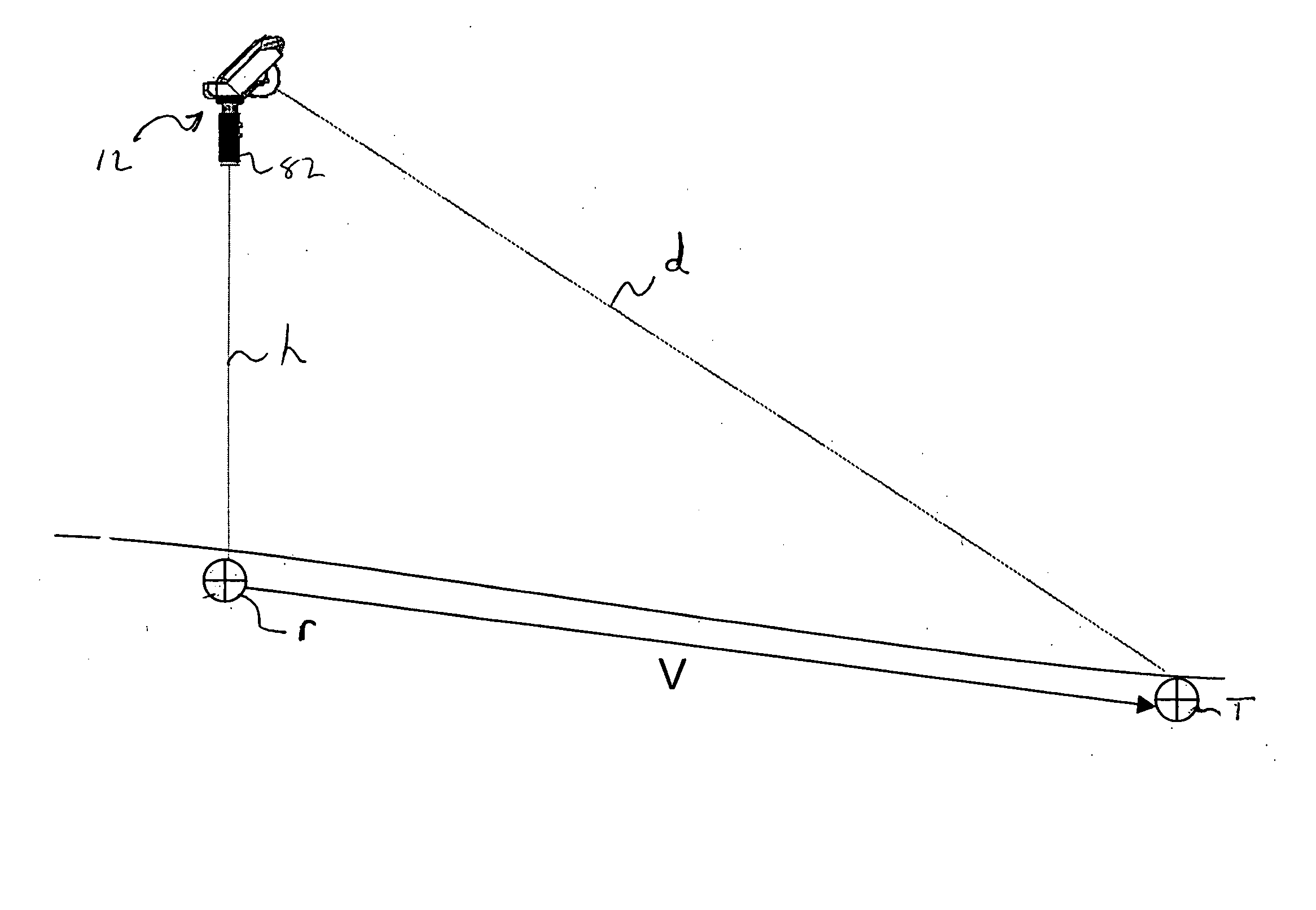
vertical axis directly beneath the measurement device (e.g., a ground reference point). In any case, measuring the distance between the device and the reference points allows for determining a relative position of the device to the reference point. For instance, this distance may correspond to a height of the device above the ground. This may allow more accurate measurements to be made between the point of reference and the point of interest. That is, error associated with the position of the device may be reduced. In any case, vector information as well as the distance and / or
angular orientation of a geophysical point of interest relative to the ground reference point may be stored. Furthermore, it will be appreciated that a plurality of geophysical points of interest may be measured and stored relative to a single ground reference point or a plurality of ground reference points for use in surveying and / or topographical map generation.
[0019] According to one particular arrangement of the present aspect, an electronic
range finding device includes a first
laser and a second
laser for use in determining the first and second distances, respectively. In this arrangement, each laser may utilize a separate
detector for use in determining light
flight time and thus distance, or these lasers may share a common
detector. The use of the first and second laser allows for the device to determine its height above the surface (i.e., ground reference point) as well as the distance to a point of interest. Such an arrangement may facilitate handheld use. In this arrangement, the sensor may be operative to provide
angular orientation of each laser or may incorporate separate sensors for providing
angular orientation of the separate lasers.
[0021] The
digital camera may include an optical
magnification and / or digital
magnification feature to allow for providing an enhanced view of a point of interest. Once such an image is acquired, the user may position a target relative to the display such that the electronic
range finding device is aimed at a corresponding position on the point of interest. This may entail, for example, moving crosshairs (e.g., through
user interface) over the
digital image to select a particular point on that image for distance and relative angular positioning. Alternatively, this may incorporate projecting a laser marker onto the geophysical point of reference such that a corresponding mark is provided on the
digital image. What is important is that the
digital image allows for a user to see a particular point of interest such that precise targeting of that point of interest may be achieved.
[0022] According to a further aspect of the present invention, a method for associating modeled data with geophysical locations is provided. The method includes identifying a reference point within a geophysical area. Based on the reference point, modeled data is associated with that geophysical area. For instance, once an absolute position of a reference point is know, modeled data may be tied to that reference point and / or oriented (e.g., relative to an
azimuth reference) such that the modeled data is overlaid onto the geophysical area. Once so associated, a point of interest may be selected from the modeled data such that that point of interest may be located on the geophysical area. Accordingly, after the point of interest is selected, a visible mark is projected on the geophysical point within the geophysical area that corresponds to the point of interest from the modeled data. This point may be then marked. As will be appreciated, the
present method facilitates
layout of modeled data in the form of, for example, construction plans onto a geophysical location.
[0026] In some instances, a point of interest from modeled data may be disposed below the current surface of a geophysical area. In this instance, the method may further include the step of projecting a mark onto the geophysical surface that, for example, is disposed on a
vertical axis above / below the point of interest. For instance, if a point of interest from the modeled data lies 5 feet below the surface, the mark projected onto the surface may be located on a
vertical axis above such point of interest and an output may be provided indicating that the projected mark is 5 feet above the actual point of interest. As will be appreciated, this may facilitate
cut and fill procedures.
[0028] The present aspect allows for the user to establish the position of a measurement device and sweep a range finding laser over the
terrain in order to generate a topographical representation of that
terrain (e.g., a topographical map). As will be appreciated, to provide adequate information for generating topographical information of a geographical area, the range finding laser may be moved between the first and second position in a raster type pattern to allow for information over an enhanced area to be incorporated into the resulting rendering. Furthermore, if the location of the reference point is known or becomes known, the actual location resulting graphical information can be tied to a predetermined coordinate
system. That is, the absolute location of the graphical information may be established.

