Road vector data integrating and updating method

A technology of vector data and update method, applied in the direction of instruments, character and pattern recognition, computer parts, etc., can solve problems such as difficulty, burden, and timeliness that cannot meet road network monitoring and emergency response, so as to reduce workload and improve time-sensitive effect

Active Publication Date: 2016-12-07
HIGHWAY MONITORING & RESPONSE CENT MINIST OF TRANSPORT OF THE P R C
View PDF3 Cites 29 Cited by
  • Summary
  • Abstract
  • Description
  • Claims
  • Application Information

AI Technical Summary

Problems solved by technology

After the integration work is completed, the annual update work will be a time-consuming, arduous and difficult task, and the timeliness of the annual cycle cannot meet the needs of road network monitoring and emergency

Method used


Image

  • Road vector data integrating and updating method
  • Road vector data integrating and updating method
  • Road vector data integrating and updating method

Examples


Embodiment Construction

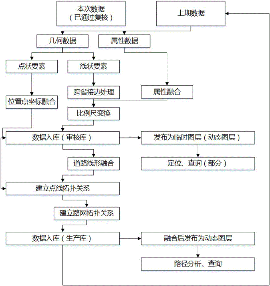
[0016] as attached figure 1 As shown, the application provides a fusion update method of highway vector data, which specifically includes the following steps:

[0017] Data integration, including: importing the latest data collected by the central node of the secondary road network, performing data inspection according to the preset rules, judging whether it meets the predetermined requirements, if not, submitting again after modification; the collected data meets the requirements and then submitting to the superior The central node of the road network conducts data review to determine whether it meets the predetermined requirements, and if not, submit it again after modification; perform data cleaning, data conversion, and data loading preprocessing on the data that passes the review, so that the coordinate system, projection method, and The elevation datum standard is unified, which satisfies the constraints of the consistent database table structure and the relationship bet...


PUM


Abstract

The invention relates to a road vector data integrating and updating method. Firstly, the most recent data acquired by the central nodes of sub-level road networks are imported for completing data collection. The linear features in the data and point features are geometrically matched for the completion of data integration. Finally, according to the established topology relationship for the road networks, the database is updated. Through the GIS software platform, a dynamically updating map is drawn to display the latest results, therefore, completing the process of data release. The method of the invention, to a large extent, enables a workman to be free of heavy, trivial, error-prone data inspection and data integration and greatly reduces the workload while improving the timeliness of data utilization.

Description

technical field [0001] The present application relates to a fusion update method of road vector data, in particular to a method for dynamic update and release of road data of different levels. Background technique [0002] In recent years, with the widespread application of geographic information systems in highway and waterway traffic operations, the demand for "one map of public waterways" has become more and more urgent. At present, the Road Network Center of the Ministry of Transport is about to complete the data fusion of the national navigation data and the annual report of the road traffic industry. Because the entrusted map data supplier is to complete all the work at one time. After the integration work is completed, the annual update work will be a time-consuming, arduous and difficult task, and the timeliness of the annual cycle cannot meet the needs of road network monitoring and emergency response. If you want to go to county roads and rural roads, the amount ...

Claims


Application Information

Patent Timeline
IPC IPC(8): G06K9/62
CPCG06F18/25G06F18/254
Inventor 龚民王虎王琰贺文涛林亨倪艳李琳冯晗江运志
Owner HIGHWAY MONITORING & RESPONSE CENT MINIST OF TRANSPORT OF THE P R C
Why Eureka
Try Eureka