A method and system for estimating the number of ground object categories in remote sensing images

A remote sensing image and category number technology, which is applied in the field of image processing, can solve the problems of poor practicability, difficulty in processing large data, and difficulty in obtaining estimation results, etc., to achieve the goals of increasing operating speed, avoiding loop iterations, and improving segmentation accuracy Effect

Active Publication Date: 2018-09-25
LIAONING TECHNICAL UNIVERSITY
View PDF2 Cites 0 Cited by
  • Summary
  • Abstract
  • Description
  • Claims
  • Application Information

AI Technical Summary

Problems solved by technology

[0002] Determining the number of categories in an image is an important task in the process of image segmentation. The current category estimation methods are mainly divided into two categories. One is to manually determine the number of categories, but this method is not suitable for high-resolution large-scale images with obvious details; The other is to automatically determine the number of categories through the design method. At present, these methods are designed with the goal of automatically determining the number of image categories and region segmentation at the same time. The principle of this design method is relatively simple, but it is highly targeted and not universal. In addition, there are many thresholds for controlling the change of the number of classes, and the interaction between multiple thresholds makes it difficult to obtain ideal estimation results, and requires a large time cost, it is difficult to process large data, and its practicability is not strong

Method used


Image

  • A method and system for estimating the number of ground object categories in remote sensing images
  • A method and system for estimating the number of ground object categories in remote sensing images
  • A method and system for estimating the number of ground object categories in remote sensing images

Examples


Embodiment Construction

[0054] The specific implementation manners of the present invention will be described in detail below in conjunction with the accompanying drawings.

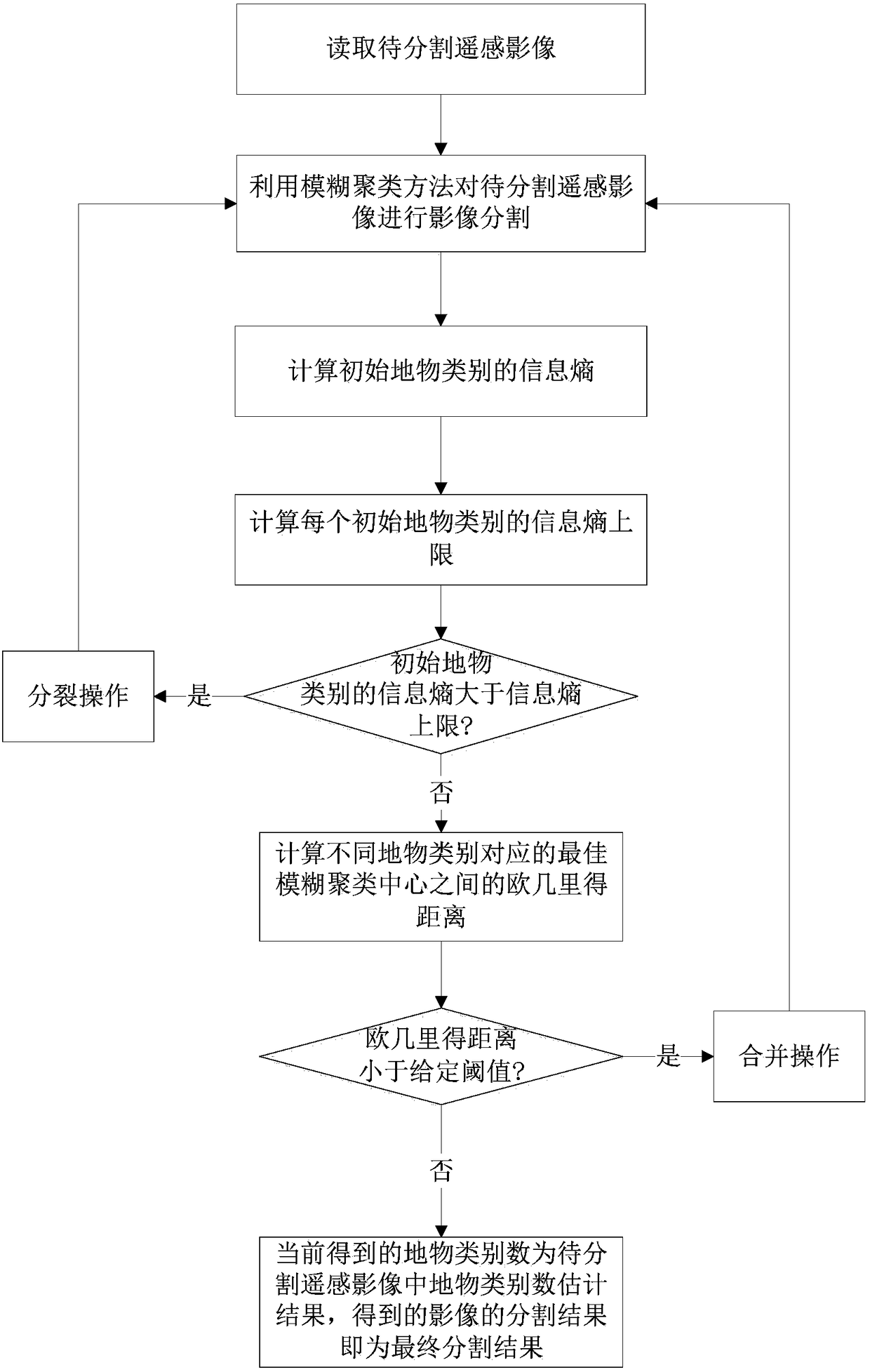
[0055] A method for estimating the number of object categories in remote sensing images, such as figure 1 shown, including:

[0056] Step 1: Read the remote sensing image to be segmented;

[0057] In this embodiment, given a remote sensing image to be segmented x={x i ;i=1,...,N}, wherein, i is the pixel index, N is the number of pixels, x i is the intensity of the i-th pixel. The size of the remote sensing image to be segmented is 128×128 pixels, and the total number of pixels n=16384.

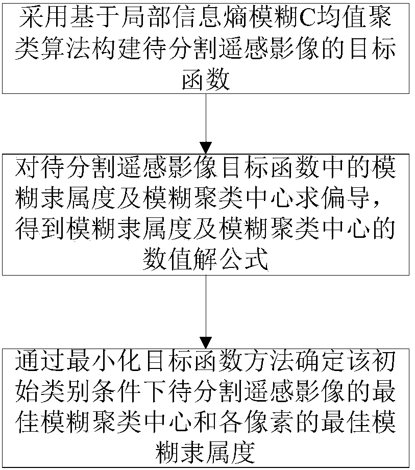
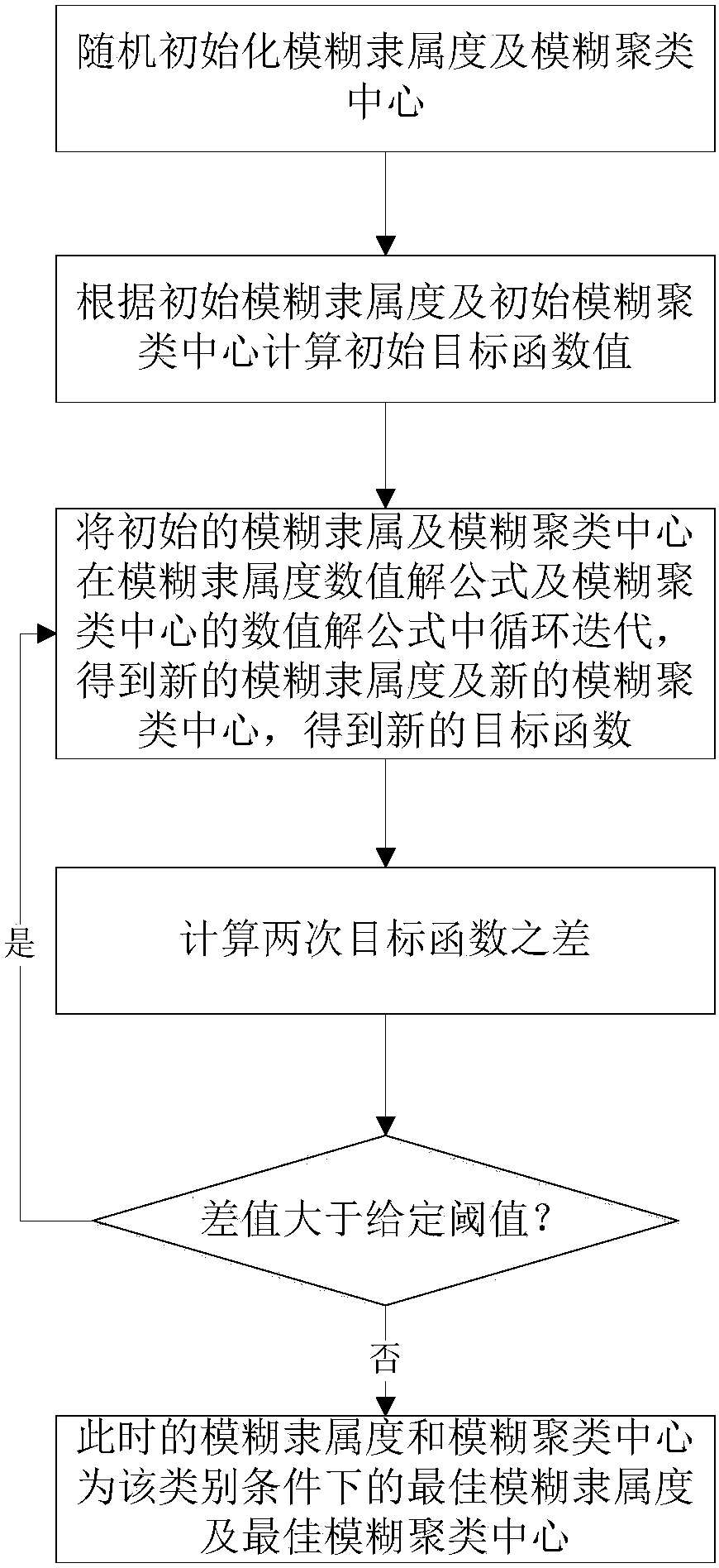
[0058] Step 2: Randomly set the number of initial object categories of the remote sensing image to be segmented, use the initial number of object categories as the number of clusters, use the fuzzy clustering method to segment the remote sensing image to be segmented, and obtain the remote sensing image to be segmented under the condition o...


PUM


Abstract

The present invention provides a method and system for estimating the number of object categories in remote sensing images. The method includes: using the fuzzy clustering method to segment the remote sensing image to be segmented to obtain the best fuzzy membership degree and the best fuzzy clustering center; The information entropy and the upper limit of the information entropy of the object category. If it is greater than the upper limit of the information entropy, the split operation is performed, otherwise the Euclidean distance between the best fuzzy clustering centers is calculated; if it is less than a given threshold, the two object categories If it is similar, perform a merge operation; otherwise, it is not similar to obtain the estimation result of the number of object categories and the final segmentation result. The invention can be combined with the traditional image segmentation method to effectively estimate the number of object categories in the remote sensing image. Based on the information entropy to measure the characteristics of the amount of information in the object category, define the split condition, and use the Euclidean distance to describe the difference between different object categories, define the merge condition, and can split the clustering algorithm that cannot be effectively distinguished in the split operation. region to improve segmentation accuracy.

Description

technical field [0001] The invention belongs to the technical field of image processing, in particular to a method and system for estimating the category number of ground objects in remote sensing images. Background technique [0002] Determining the number of categories in an image is an important task in the process of image segmentation. The current category estimation methods are mainly divided into two categories. One is to manually determine the number of categories, but this method is not suitable for high-resolution large-scale images with obvious details; The other is to automatically determine the number of categories through the design method. At present, these methods are designed with the goal of automatically determining the number of image categories and region segmentation at the same time. This design method is relatively simple in principle, but it is highly targeted and not universal. In addition, there are many thresholds to control the change of the numb...

Claims


Application Information

Patent Timeline
Patent Type & Authority Patents(China)
IPC IPC(8): G06T7/11G06T7/136
Inventor 王春艳徐爱功王丽英胡海峰
Owner LIAONING TECHNICAL UNIVERSITY
Why Eureka
Try Eureka