Unmanned aerial vehicle target positioning method and system

A target positioning and UAV technology, applied in the field of UAV target positioning methods and systems, can solve the problems of low contrast blur or even occlusion, changeable imaging conditions, complex flight characteristics, etc. The effect of precision

Inactive Publication Date: 2017-01-04
HARBIN UNIV OF SCI & TECH
View PDF4 Cites 16 Cited by
  • Summary
  • Abstract
  • Description
  • Claims
  • Application Information

AI Technical Summary

Problems solved by technology

[0003] However, since the UAV is a special flight carrier with complex flight characteristics, high flight speed, and variable imaging conditions, it has more complex image motion characteristics, because it is affected by external factors such as weather, light, and noise. Human-machine reconnaissance images inevitably have low contrast, blur or even occlusion, and due to differences in image acquisition devices, there are inevitably scale changes, rotation changes, and illumination changes between UAV reconnaissance images and remote sensing images in the database.
The target image information cannot be quickly and accurately matched from the massive remote sensing image data, that is, the UAV target positioning in the prior art has a technical defect of low positioning accuracy

Method used


Image

  • Unmanned aerial vehicle target positioning method and system
  • Unmanned aerial vehicle target positioning method and system
  • Unmanned aerial vehicle target positioning method and system

Examples


Embodiment 1

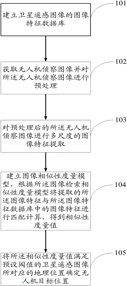
[0045] figure 1 It is a schematic flow diagram of the method of the embodiment of the present invention, such as figure 1 As shown, a UAV target positioning method includes:

[0046] Step 101: establishing an image feature database of satellite remote sensing images;

[0047] Step 102: Acquiring the UAV reconnaissance image and preprocessing the UAV reconnaissance image;

[0048] Step 103: performing multi-scale image feature extraction on the preprocessed UAV reconnaissance image;

[0049] Step 104: Establish a granular computing-based image retrieval similarity measurement model, and perform matching calculations on the extracted image features and image features in the image feature database according to the image retrieval similarity measurement model to obtain a similarity measurement value;

[0050] Step 105: Determine the geographic location corresponding to the satellite remote sensing image whose similarity metric value satisfies a preset threshold as the UAV targe...

Embodiment 2

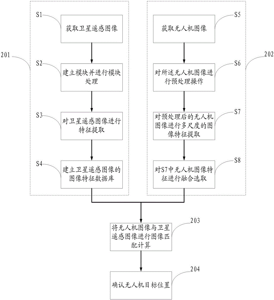
[0052] figure 2 It is a schematic flow diagram of the method of Embodiment 2 of the present invention, such as figure 2 As shown, a UAV target positioning method includes:

[0053] Step 201: Establishing an image feature database of satellite remote sensing images, the establishment of an image feature database of satellite remote sensing images includes the following operations:

[0054] S1: Obtain satellite remote sensing images;

[0055] S2: Establish a module and perform module processing, and accurately calculate the corresponding geographic location of the satellite remote sensing image by splicing small pieces of maps;

[0056] S3: performing feature extraction on the satellite remote sensing image, extracting the image features of the remote sensing satellite image, and correspondingly storing the image feature of the remote sensing satellite image and the corresponding geographic location;

[0057] S4: Establish an image feature database of satellite remote sensi...

Embodiment 3

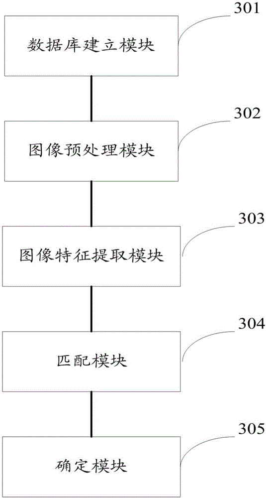
[0079] image 3 It is a schematic diagram of the system module of Embodiment 3 of the present invention, such as image 3 As shown, a UAV target positioning system includes:

[0080] Database building module 301, used to set up an image feature database of satellite remote sensing images;

[0081] An image preprocessing module 302, configured to acquire unmanned aerial vehicle reconnaissance images and preprocess the unmanned aerial vehicle reconnaissance images;

[0082] An image feature extraction module 303, configured to perform multi-scale image feature extraction on the preprocessed UAV reconnaissance image;

[0083] The matching module 304 is configured to establish an image retrieval similarity measurement model based on granular computing, and perform matching calculation on the extracted image features and image features in the image feature database according to the image retrieval similarity measurement model to obtain similarity measure of sex;

[0084] A dete...


PUM


Abstract

The invention provides an unmanned aerial vehicle target positioning method and system. The method comprises the steps that an image feature database of a satellite remote sensing image is established; an unmanned aerial vehicle reconnaissance image is acquired and preprocessed; multi-scale image feature extracting is carried out on the preprocessed unmanned aerial vehicle reconnaissance image; an image retrieval similarity measurement model based on granular computing is established, and matching computing is carried out on the extracted image features and image features in the image feature database according to the image retrieval similarity measurement model to acquire a similarity measurement value; and the geographic position corresponding to the satellite remote sensing image with the similarity measurement value satisfying a preset threshold value is determined as the unmanned aerial vehicle target position. The method and system can accurately position an unmanned aerial vehicle target.

Description

technical field [0001] The invention relates to the field of UAV target positioning, in particular to a method and system for UAV target positioning. Background technique [0002] The dependence of modern warfare on information makes drones play an increasingly important role. The outstanding performance of drones in several high-tech local wars has attracted great attention from all countries in the world. Many countries have begun to vigorously develop military drones. technology. In order to meet the requirements of precise strikes in modern information warfare, the use of UAV reconnaissance images to achieve precise positioning of the detection target area in geospatial position is the key technology. The principle is to first model the electronic satellite remote sensing map data and build a database module , and then match the current image taken by the UAV to the corresponding satellite map module information from the massive electronic satellite remote sensing image...

Claims


Application Information

Patent Timeline
IPC IPC(8): G06K9/00G06K9/34G06K9/62G06K9/46G06F17/30
CPCG06F16/50G06V20/13G06V10/267G06V10/40G06F18/23G06F18/22G06F18/253
Inventor 李胜明颜颐欣孟绍良
Owner HARBIN UNIV OF SCI & TECH
Why Eureka
Try Eureka