Nonlinear method for describing urban surface landscape structure

A landscape structure, nonlinear technology, applied in special data processing applications, instruments, electrical digital data processing, etc., can solve problems such as single fractal failure to reflect multi-scale characteristics of thermal fields

Inactive Publication Date: 2017-03-08
XUCHANG UNIV
View PDF1 Cites 2 Cited by
  • Summary
  • Abstract
  • Description
  • Claims
  • Application Information

AI Technical Summary

Problems solved by technology

Although both landscape ecology and fractal can describe the pattern of urban thermal field and reflect the scale characteristics of urban thermal field, landscape ecology lacks the consideration of self-similarity and singularity measurement of thermal field itself, while single fractal cannot Reflecting the multi-scale characteristics of the thermal field

Method used


Image

  • Nonlinear method for describing urban surface landscape structure
  • Nonlinear method for describing urban surface landscape structure
  • Nonlinear method for describing urban surface landscape structure

Examples


Embodiment Construction

[0033] The specific content of the present invention is as follows:

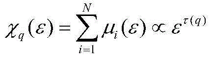
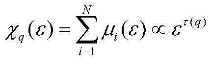
[0034] A non-linear method for describing the structure of the urban landscape. First, the temperature difference in the measurement area is selected in the study of the thermal field pattern. Assuming that the image is M×N pixels, a set of square boxes with different scales are used to cover the entire image area ( Need (M / ε)×(N / ε)), calculate the temperature difference ΔT in each box ε =(T max -T min ) / ε, put ΔT ε Imagine the height of the image surface, and then use ΔT ε +1 box to cover, you can use μ(ε)=(ΔT ε +1) / Σ(ΔT ε +1) to obtain the area measure;

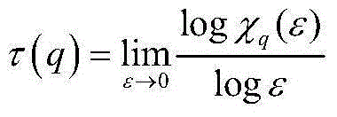
[0035] Take -10 q (ε), find the quality index τ(q) in the double logarithmic coordinate system;

[0036] Use the formula α(q)=(τ(q+1)-τ(q-1)) / 2 to calculate α(q);

[0037] Calculate f(α) using the formula f(α)=qα(q)-α(q).

[0038] The multifractal theory is briefly described as follows:

[0039] For continuous random spatially distributed variables with geometri...


PUM


Abstract

The invention discloses a nonlinear method for describing an urban surface landscape structure. The method comprises the steps of 1, performing temperature retrieval: calculating a radiation energy value, a radiation brightness temperature and a ground temperature; 2, for a temperature difference of measure selection regions in thermal field pattern study, assuming that an image has MXN pixels, performing coverage ((M/epsilon)X(N/epsilon) square boxes are required) on a whole image region by using a group of square boxes of different dimensions epsilon, calculating a temperature difference delta T epsilon (delta T epsilon = (Tmax-Tmin)/epsilon) in each box, imagining delta T epsilon as the height of an image curve, then performing coverage by using (delta T epsilon + 1) boxes, and calculating regional measure by using a formula: mu (epsilon) = (delta T epsilon + 1)/sigma (delta T epsilon + 1); 3, enabling q to be greater than -10 and less than 10, calculating a partition function xq(epsilon), and calculating a quality index tau (q) in a double-logarithmic coordinate system; 4, calculating alpha (q) by using a formula: alpha (q) = (tau (q+1) - tau (q-1))/2; and 5, calculating f(alpha) by using a formula: f (alpha) = q alpha (q) - alpha (q).

Description

Technical field [0001] The invention relates to a method for modeling urban thermal environment field texture structure. Background technique [0002] The heat island is caused by the city itself. In addition to the influence of external weather conditions such as wind speed and air pressure, this "self" should refer to the urban surface structure, the spatial structure or arrangement of ground buildings, and human factors. In the process of urban development, changes in the surface structure inevitably change the distribution of solar radiation budgets, leading to differences in surface radiation and atmospheric temperature between cities and suburbs. The difference in temperature between cities and suburbs is commonly referred to as the urban heat island effect. Has always received people's attention. [0003] On the one hand, changes in the surface structure result in changes in land cover types, such as muddy soil turning into cement ground, vegetation reduction, etc. Existin...

Claims


Application Information

Patent Timeline
Patent Type & Authority Applications(China)
IPC IPC(8): G06F19/00
Inventor 高歆
Owner XUCHANG UNIV
Why Eureka
Try Eureka