
Classifying method for water level and dangerous areas of flooding disaster along river passing mountainous villages in hilly region

A technology for dangerous areas and villages, applied in structured data retrieval, instruments, climate change adaptation, etc., can solve the problems of less accurate villages along the river, difficulties in popularization and application, and insufficient applicability

Inactive Publication Date: 2017-03-15
UNIV OF JINAN
View PDF1 Cites 8 Cited by
  • Summary
  • Abstract
  • Description
  • Claims
  • Application Information

AI Technical Summary

Problems solved by technology

[0003] Existing research on mountain torrent disaster prevention, on the one hand, mostly takes larger watersheds as the research object, and calculates the overall flood control capacity of the river, which is less accurate to the villages along the river, and cannot be given according to the local special topography, small watershed characteristics, and river cross-section data. The current flood control capacity of each village along the river and quantitative assessment
On the other hand, some studies have taken the villages along the river as the research objects, but they did not consider the factors of the river channel, flood gradient and the distribution of households along the river when determining the disaster-causing water level and demarcating the dangerous area. Only one The water level elevation is used as the disaster (early warning) water level, resulting in poor accuracy of the village's dangerous area and the disaster water level
On the other hand, there are also some scholars who establish one- and two-dimensional hydraulic models and use the spatial analysis function of high-precision DEM data GIS to divide dangerous areas. However, this method has a cumbersome calculation process and requires high data requirements. In practice, the applicability is insufficient, and there are certain difficulties in popularization and application

Method used


Image

  • Classifying method for water level and dangerous areas of flooding disaster along river passing mountainous villages in hilly region
  • Classifying method for water level and dangerous areas of flooding disaster along river passing mountainous villages in hilly region
  • Classifying method for water level and dangerous areas of flooding disaster along river passing mountainous villages in hilly region

Examples


Embodiment Construction

[0090] The present invention will be further described below in conjunction with the accompanying drawings and embodiments.

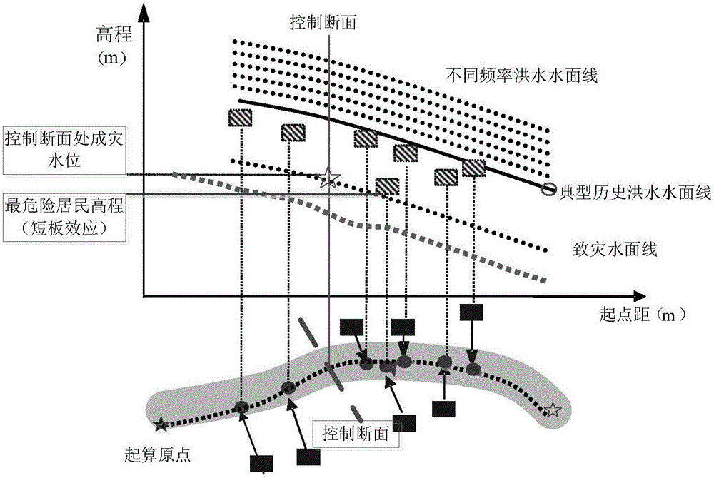
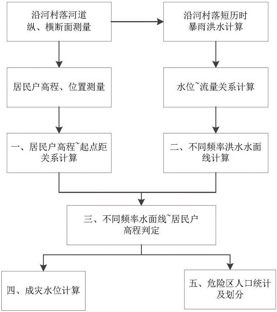
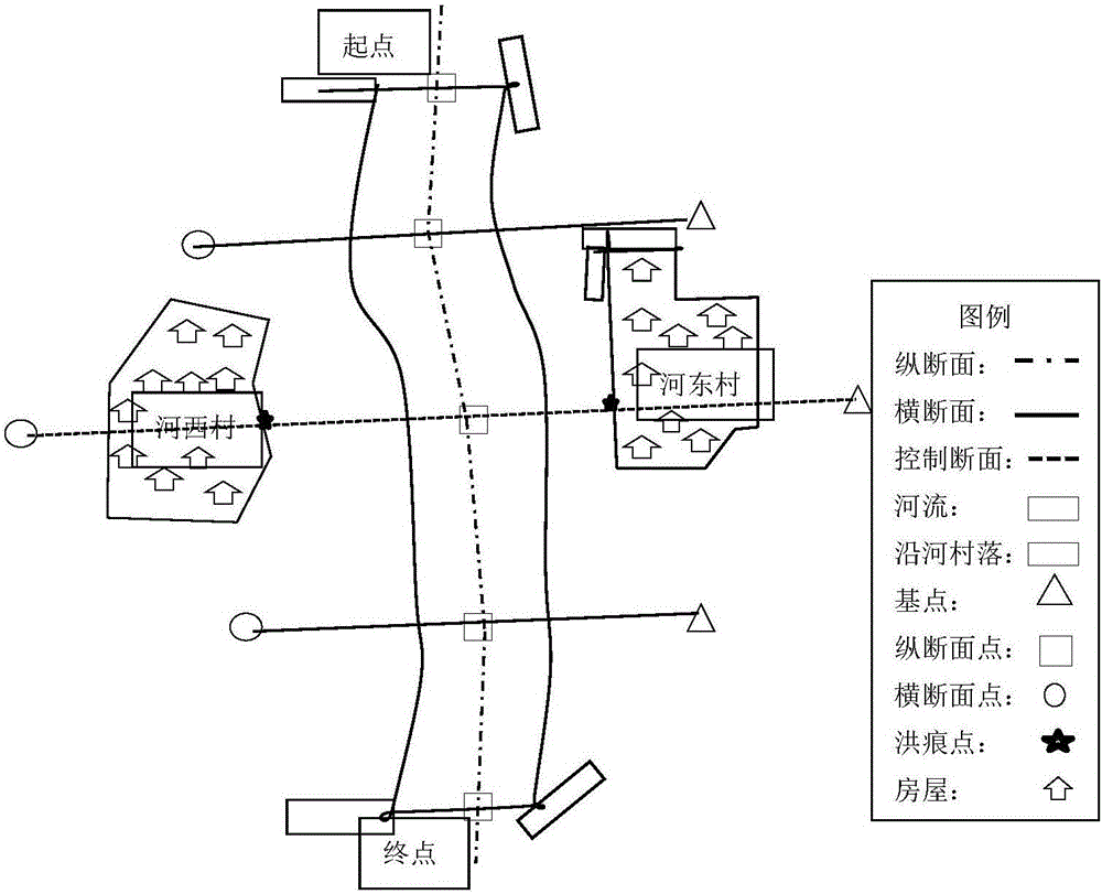
[0091] The present invention provides a method for dividing water levels and dangerous areas caused by mountain torrent disasters in villages along rivers in hilly areas. It uses relatively simple data and materials, and integrates cross-section surveying and mapping, river channel investigation, storm flood calculation, water level and flow relationship calculation, point projection, Multidisciplinary and different methods such as point-line relationship judgment, mainly including the calculation of water surface lines at different flood frequencies in villages along the river, the calculation of the relationship between the elevation of residential households and the distance from the starting point, the determination of the relationship between water surface line / residential household elevation (drawing dangerous areas), and the determination of the mo...


PUM


Abstract

The invention discloses a classifying method for water level and dangerous areas of flooding disaster along river passing mountainous villages in hilly region. The method comprises the following steps: measuring the horizontal and longitudinal sections of the village along a river as well as the horizons and the heights of residences of villagers along the river; projecting the residences of villagers along the river onto the middle line of the river; calculating the relationship of the height of each residence with the starting distance; calculating the flood peak flows in the river controlling section face of the village along the river corresponding to heavy rains of different frequencies; calculating the relationship of the section face water level and the flow of the village along the river; calculating the controlled section face water level under different frequencies; drawing the flooding water surface lines corresponding to the different frequencies; creating the determination formula between the residences along the river and the flooding water surface lines; determining the relationship between the residences along the river and the flooding water surface lines of different frequencies so as to determine the residences of the flooding water surface lines of different frequencies; and according to the relationship between the villagers along the river and the flooding surface liens of different frequencies, screening the most vulnerable residences along the path of the river; transforming them into the water level to cause disasters at a controlling section face; and classifying the residences along the river as dangerous areas of different levels.

Description

technical field [0001] The invention relates to a method for dividing water levels and dangerous areas of mountain torrent disasters in villages along rivers in hilly areas, and belongs to the field of disaster prevention and reduction. Background technique [0002] In recent years, due to the joint influence of multiple factors such as complex geological terrain conditions, climatic factors, dense population distribution, and human activities, sudden local extreme heavy rainfall in my country has caused frequent mountain torrent disasters, resulting in a large number of casualties. On July 19, 2016, due to the sudden torrential rain in the upper reaches, the Qili River in Xingtai, Hebei Province suddenly flooded. The flood overflowed the embankment breach and caused the loss of life and property of the people in Daxian Village. Torrential rain and torrents in small watersheds in hilly areas are formed due to heavy rainfall, and the ditch (river) gradient in hilly areas is g...

Claims


Application Information

Patent Timeline
IPC IPC(8): G06Q50/26G06F17/30
CPCG06F16/29G06Q50/26Y02A10/40
Inventor 桑国庆王豪刘志鹏闫飞郭志彬庞桂斌武玮宋淑馨王英
Owner UNIV OF JINAN
Learn More