Navigation device and map display method thereof

A navigation device and map technology, applied in navigation, surveying devices, surveying and navigation, etc., can solve the problems of doubts about the positioning accuracy of navigation devices, the current position deviates from the road 12, etc., and achieve the effect of eliminating doubts

Active Publication Date: 2021-03-12
ALPINE ELECTRONICS INC +1
View PDF10 Cites 0 Cited by
  • Summary
  • Abstract
  • Description
  • Claims
  • Application Information

AI Technical Summary

Problems solved by technology

As shown in the figure, on the map display screen, the current position of the vehicle 10 calculated by the gyroscope is not displayed on the linear road 12, so after the user sees it, the current position of the vehicle may easily deviate from the road 12. There will also be doubts about the positioning accuracy of the navigation device

Method used


Image

  • Navigation device and map display method thereof
  • Navigation device and map display method thereof
  • Navigation device and map display method thereof

Examples


Embodiment Construction

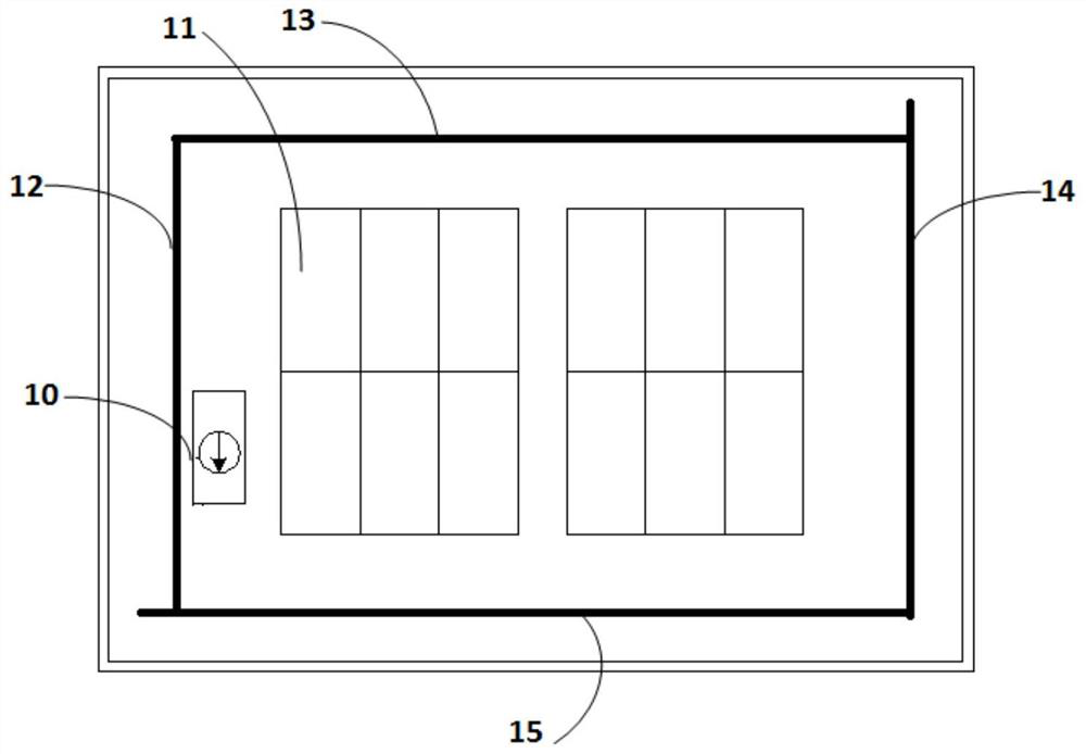
[0023] Hereinafter, embodiments of the present invention will be described in detail by taking a vehicle-mounted navigation device as an example with reference to the accompanying drawings. In addition, although the present embodiment is described with respect to the map road in the parking lot, the present invention is not limited thereto, and is also applicable to other map roads.

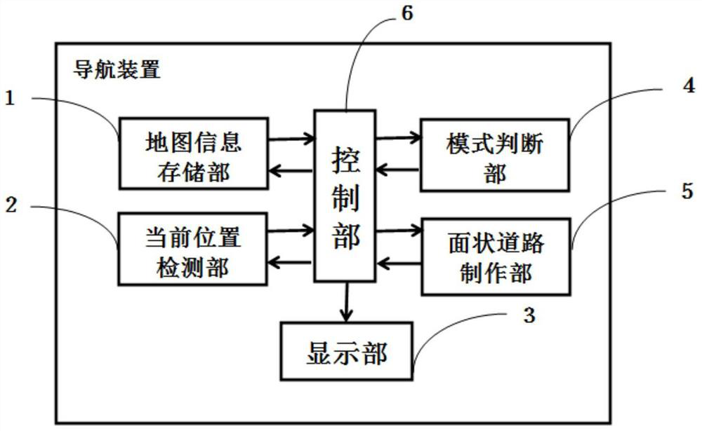
[0024] figure 2 is a block diagram showing the structure of the present invention. As shown in the figure, the car navigation device of this embodiment includes a map information storage unit 1 , a current position detection unit 2 , a display unit 3 , a mode determination unit 4 , a planar road creation unit 5 , and a control unit 6 .

[0025] The map information storage unit 1 is composed of a non-volatile memory such as a flash memory, or a volatile memory such as a RAM (Random Access Memory), or a combination of the two, and may also be composed of a CD-ROM as an optical storage medium, or ...


PUM


Abstract

The present invention provides a navigation device and a map display method thereof capable of displaying the current position of the vehicle on a map road even if the current vehicle is in a parking mode. Equipped with: a map information storage unit for storing map information including linear road-related information; a display unit for displaying a map with linear roads based on the map information; a planar road creation unit for creating planar roads based on the linear road-related information The road, and the control unit, through the above-mentioned planar road creation unit, make linear roads within a predetermined range around the vehicle position or within the range of the display screen into planar roads, and display a map with planar roads on the display unit . According to the present invention, the current position of the vehicle can be displayed on the map road, and the user's confusion about the display of the current position of the vehicle can be eliminated.

Description

technical field [0001] The present invention relates to a navigation device and a map display method thereof, in particular to a navigation device and a map display method thereof which switch road shapes displayed on a map display screen according to a vehicle positioning mode. Background technique [0002] In recent years, as a detection device for detecting the current position of the vehicle, for example, a well-known vehicle navigation device detects the current position of the vehicle through GPS (Global Positioning System) satellite positioning, and displays the detected current position on the map display screen of the vehicle device. A vehicle marker representing the vehicle's position is displayed on the location so that the vehicle can be located. [0003] In addition, according to the current position of the vehicle and the running state of the vehicle, the positioning mode of the vehicle is divided into two types: parking mode and map matching mode. The map mat...

Claims


Application Information

Patent Timeline
Patent Type & Authority Patents(China)
IPC IPC(8): G01C21/32G01C21/34
CPCG01C21/32G01C21/3415
Inventor 曹晓明蔡英达
Owner ALPINE ELECTRONICS INC
Why Eureka
Try Eureka