A Method of Automatic Extraction of Mountain Boundary

An automatic extraction and mountain technology, applied in the field of geographic information, can solve the problems of broken mountain boundaries, low efficiency, and large investment

Active Publication Date: 2020-04-03
NANJING NORMAL UNIVERSITY
View PDF5 Cites 0 Cited by
  • Summary
  • Abstract
  • Description
  • Claims
  • Application Information

AI Technical Summary

Problems solved by technology

[0004] Due to the complexity of mountain terrain and multi-scale problems, when the above method is implemented, the extracted mountain boundary is relatively broken, which is inconsistent with the mountain boundary from the geographical perspective. It is difficult to meet the needs of geographical research, and further manual processing is required, which requires a large investment and low efficiency.

Method used


Image

  • A Method of Automatic Extraction of Mountain Boundary
  • A Method of Automatic Extraction of Mountain Boundary
  • A Method of Automatic Extraction of Mountain Boundary

Examples


Embodiment

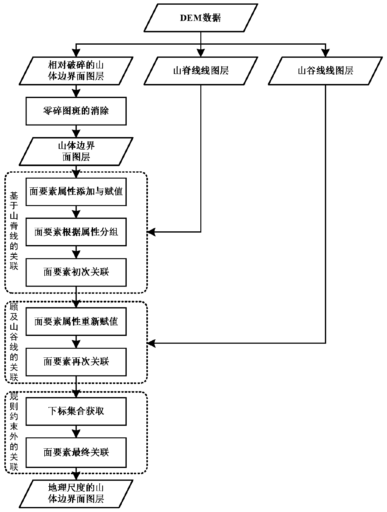
[0077] Embodiment: a kind of mountain boundary automatic extraction method, as figure 1 As shown, the specific operation is as follows:

[0078] Step (1) specifically includes:

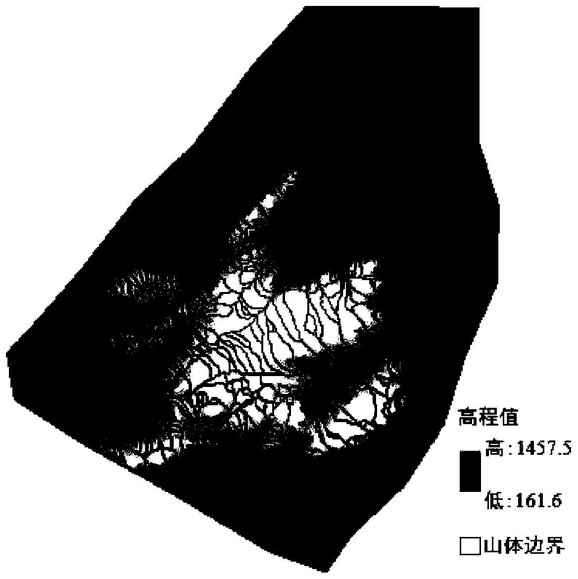
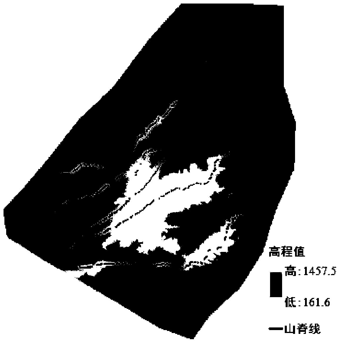
[0079] (1-1) Load the DEM data, and with the help of ArcGIS software, based on the principle of terrain surface hydrological analysis, obtain the vector mountain boundary layer ( figure 2 ), the ridgeline layer ( image 3 ) and valley line layer data ( Figure 4 );

[0080] (1-2) For the relatively broken mountain boundary surface layer, use the elimination tool in ArcGIS to eliminate the area less than 100m with the Area threshold 2 After adjusting the size of the threshold, after 7 times of elimination, the final elimination area is less than 30,000 m 2 , to get the mountain boundary surface feature layer ( Figure 5 ).

[0081] Step (2) specifically includes:

[0082] (2-1) Load the mountain boundary surface feature layer, the ridge line feature layer and the valley line feature layer to o...


PUM


Abstract

The invention provides a mountain boundary automatic extracting method. The mountain boundary automatic extracting method includes: acquiring mountain boundary surface data, mountain ridge line data and valley line data; associating surfaces which a mountain ridge passes through, and initially forming a mountain boundary; searching surfaces having an adjacent relationship with the mountain boundary surface, using a valley line as a constraint, and associating surfaces meeting a condition; and associating surfaces outside the rule constraint condition, and finally forming a mountain boundary with geographical scales. The mountain boundary automatic extracting method associates the surfaces meeting the condition with the valley line as the constraint on the basis of the mountain boundary surface data, and achieves automatic extraction of the mountain boundary with geographical scales; the extracted mountain is complete, is reasonable in scales, can directly meet the demands of geographical research, can be used as a basis for constructing a mountain object, can provide effective supports for feature analysis of geomorphology and humanity, mountain reconstruction after geological disasters, and terrain multi-scale synthesizing.

Description

technical field [0001] The invention relates to the technical field of geographic information, in particular to a method for automatically extracting mountain boundaries. Background technique [0002] At present, in the existing terrain models, regular sampling points, triangular patches, contour lines, etc. are usually used to express mountains, and avoid directly expressing mountain objects. In fact, there are phenomena such as mountains and river valleys in the terrain, and their positions and shapes can also be clarified, which shows that there are objects in the terrain. In geomorphology, mountains are an important topographic object, and their construction mainly has the following necessity: (1) to provide services for the analysis of geomorphic features in geomorphology and hydrological features in hydrology; (2) in terms of geological disasters, It can make rapid changes and adjustments during mountain reconstruction; (3) The object model of mountains can provide ch...

Claims


Application Information

Patent Timeline
Patent Type & Authority Patents(China)
IPC IPC(8): G06F16/29G06T7/13
CPCG06F16/29G06T2207/30184
Inventor 李梦圆李安波解宪丽陈楹王凯亮姚蒙蒙
Owner NANJING NORMAL UNIVERSITY
Why Eureka
Try Eureka