Maize automatic mapping method based on nmdi increase-decrease ratio index in peak growth period

A ratio index, automatic mapping technology, applied in the re-radiation of electromagnetic waves, instruments, color/spectral characteristics measurement, etc., can solve the problems of the difference in the time series curve of the vegetation index within the year, and it is difficult to establish different crops, etc., to achieve clear methods and results. Stable and reliable, the effect of eliminating signal interference

Inactive Publication Date: 2019-02-22
FUZHOU UNIV
View PDF3 Cites 0 Cited by
  • Summary
  • Abstract
  • Description
  • Claims
  • Application Information

AI Technical Summary

Problems solved by technology

The most fundamental problem faced by such methods is that due to changes in crop phenology, management measures, and climatic conditions in different regions, there may be very large differences in the annual vegetation index time-series curves of the same crop. It is difficult to establish the time-series curve of standard vegetation index for different crops

Method used


Image

  • Maize automatic mapping method based on nmdi increase-decrease ratio index in peak growth period
  • Maize automatic mapping method based on nmdi increase-decrease ratio index in peak growth period
  • Maize automatic mapping method based on nmdi increase-decrease ratio index in peak growth period

Examples


Embodiment Construction

[0033] The present invention will be further described below in conjunction with the accompanying drawings and embodiments.

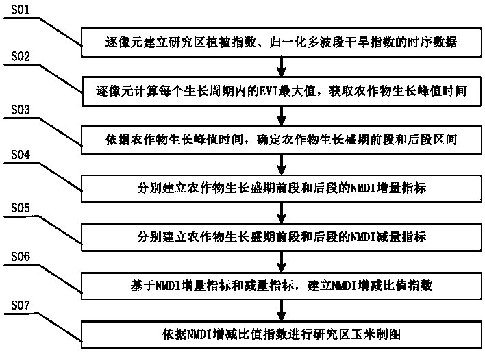
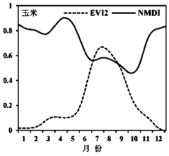
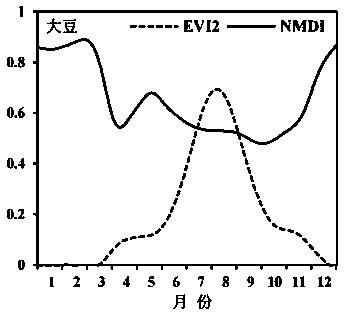
[0034] Please refer to figure 1 , the present invention provides an automatic mapping method for corn based on the NMDI increase-decrease ratio index in the peak growth period. Firstly, an intra-year time-series data set of the normalized multi-band drought index and vegetation index in the research area is established, and then based on the vegetation index time-series data, image-by-image The maximum value of the vegetation index in each growth cycle is detected, and according to the peak growth time of crops, the intervals of the early and late stages of the crop growth period are determined. On this basis, based on the time series data set of the normalized multi-band drought index NMDI, respectively Establish the NMDI increment and decrement indicators of the early and late intervals of the crop growth period, and establish the NMDI increase-decrea...


PUM


Abstract

The invention relates to an automatic corn mapping method based on active growth stage NMDI (normalized multi-band drought index) increase and decrease ratio indexes. The mapping method includes the steps: building a vegetation index time sequence dataset and NMDI time sequence dataset of a research area pixel by pixel; calculating EVI (enhanced vegetation index) maximum values of crops in each growth period pixel by pixel, and acquiring growth peak value time of the crops; determining a front interval of the active growth stage of the crops and a back interval of the active growth stage of the crops according to the growth peak value time of the crops; respectively building NMDI increment indexes of the front interval of the active growth stage of the crops and NMDI increment indexes of the back interval of the active growth stage of the crops; respectively building NMDI decrement indexes of the front interval of the active growth stage of the crops and NMDI decrement indexes of the back interval of the active growth stage of the crops; building NMDI increase and decrease ratio indexes based on the NMDI increment indexes and the NMDI decrement indexes; performing mapping on corns in the research area according to the NMDI increase and decrease ratio indexes. The mapping method has the advantages of high automation degree and classification accuracy, simplicity, easiness in use, good robustness and the like.

Description

technical field [0001] The invention relates to an automatic mapping method for corn based on the NMDI increase-decrease ratio index in the peak growth period. Background technique [0002] Accurately and quickly grasping the planting area and its spatial distribution of crops is crucial to ensuring food security in a populous country. The traditional agricultural sampling survey method is difficult to break through the limitations of high cost, time-consuming and inability to fully cover. Remote sensing images have the characteristics of strong timeliness and large coverage, and have played an important role in the monitoring of crop area. Due to the certain similarity of the spectra of different crops, it brings serious challenges to the classification method based on a single or a few remote sensing images. Therefore, remote sensing monitoring of crop area based on time-series remote sensing images has become the core development direction. [0003] At present, the met...

Claims


Application Information

Patent Timeline
Patent Type & Authority Patents(China)
IPC IPC(8): G01S17/89G01S7/48G01N21/25
CPCG01N21/25G01N2021/1793G01S7/4802G01S17/89
Inventor 邱炳文罗钰涵
Owner FUZHOU UNIV
Why Eureka
Try Eureka