Unlock instant, AI-driven research and patent intelligence for your innovation.

Ultrahigh-resolution GIS (geographic information system) map control large system and method

A GIS map and ultra-high-resolution technology, applied in the field of Internet communication, can solve the problems of losing effective information and reducing the detailed information of GIS maps, and achieve the effect of ensuring integrity

Active Publication Date: 2017-05-31
上海寰视网络科技有限公司
View PDF4 Cites 7 Cited by
  • Summary
  • Abstract
  • Description
  • Claims
  • Application Information

AI Technical Summary

Problems solved by technology

[0003] In the process of using the existing GIS map, the high-resolution GIS map is generated into a low-resolution image, which is convenient for users and practical. However, such an operation often reduces the detailed information in the GIS map, and even loses some effective information. information

Method used


Image

  • Ultrahigh-resolution GIS (geographic information system) map control large system and method
  • Ultrahigh-resolution GIS (geographic information system) map control large system and method
  • Ultrahigh-resolution GIS (geographic information system) map control large system and method

Examples


Embodiment

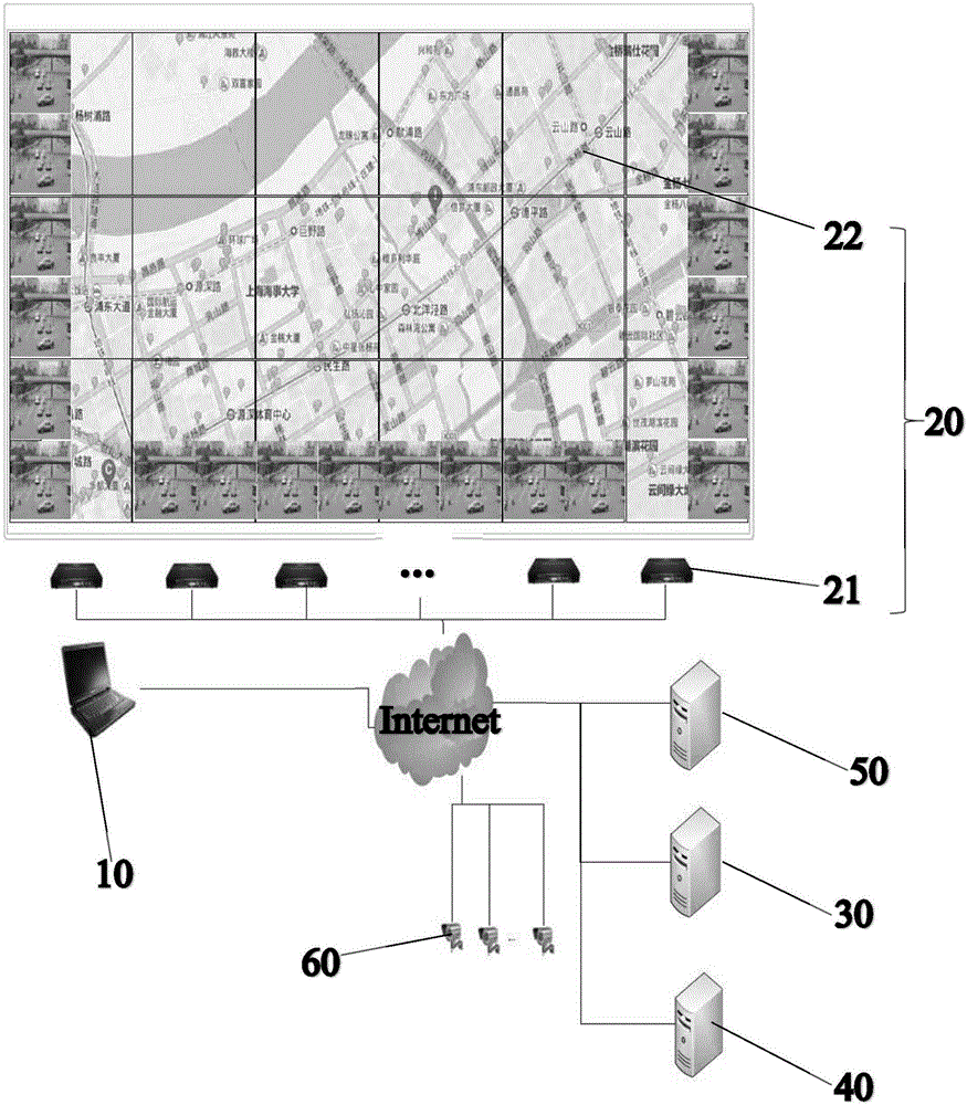
[0048] like figure 1 As shown, a large-screen system for ultra-high resolution GIS map control includes: a control terminal 10, a display terminal 20, a GIS map processing server 30, a process communication server 40, a management server 50, and N camera devices 60. The control The terminal 10 is respectively connected to the display terminal 20, the GIS map processing server 30, the process communication server 40, and the management server 50 through the network. The GIS map processing server 30, the process communication server 40, and the management server 50 are connected by communication. The process communication server 40 communicates with the N camera devices 60 respectively through the network.

[0049] In the above-mentioned ultra-high resolution GIS map control large-screen system:

[0050] Control terminal 10: used to issue control instructions to the system; at the same time, the user synchronously displays part of the content of the display terminal as required; ...


PUM


Abstract

The invention provides an ultrahigh-resolution GIS (geographic information system) map control large system and method. The system comprises a control terminal, a display terminal, a GIS map processing server and a process communication server, and the control terminal is in communication connection with the display terminal, the GIS map processing server and the process communication server through a network respectively. The method includes: dividing a GIS map into a group of non-overlapped splicing pieces including multi-line splicing pieces and multi-row splicing pieces; converting the splicing pieces from RGB format into YUV format; coding the splicing pieces in the YUV format to form h264 data; sending the h264 data to corresponding decoders through a core switch; decoding the received h264 data by each decoder; outputting the decoded splicing pieces to a corresponding display unit for display by each decoder. By the ultrahigh-resolution GIS map control large system and method, high resolution of a GIS map is maintained, and portable and movable effects of the control terminal are realized while display effect of a large screen is considered.

Description

technical field [0001] The invention relates to the technical field of Internet communication, in particular to a system and method for controlling a large screen with an ultra-high resolution GIS map. Background technique [0002] GIS, Geographic Information System (Geographic Information System or Geo-Informationsystem) is sometimes called "geographic information system". It is a specific and very important spatial information system. It is a technical system that collects, stores, manages, calculates, analyzes, displays and describes the relevant geographical distribution data in the entire or part of the earth's surface (including the atmosphere) space with the support of computer hardware and software systems. Location and geographic information are both the core and the foundation of LBS (Location-Based Services). A simple latitude and longitude coordinate will be recognized and understood by users only after it is placed in specific geographic information and repres...

Claims


Application Information

Patent Timeline
IPC IPC(8): G06F3/14G06F17/30H04N5/262H04N5/268
CPCG06F3/1446G06F16/29H04N5/262H04N5/268
Inventor 田永存陈黎平黄亚辉
Owner 上海寰视网络科技有限公司