Three-dimensional point cloud road boundary automatic extraction method

A 3D point cloud and automatic extraction technology, applied in the field of point cloud processing, can solve the problems of road surface loss details and difficulties

Active Publication Date: 2017-05-31
XIAMEN UNIV
View PDF2 Cites 53 Cited by
  • Summary
  • Abstract
  • Description
  • Claims
  • Application Information

AI Technical Summary

Problems solved by technology

Using the method based on random sampling consensus (RANSAC) to extract road surfaces will have difficulties in the face of road undulations, and often the extracted road surfaces will lose some details
However, the method of using Gaussian filtering method or sliding window method to detect curbs often has challenges when facing irregular road boundaries (such as walls, fences) or surrounding vegetation.

Method used


Image

  • Three-dimensional point cloud road boundary automatic extraction method
  • Three-dimensional point cloud road boundary automatic extraction method
  • Three-dimensional point cloud road boundary automatic extraction method

Examples


Embodiment

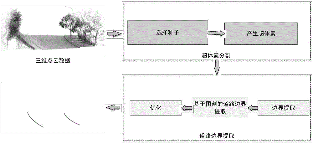
[0063] The specific implementation scheme of the road boundary extraction method based on the vehicle-mounted laser scanning point cloud data proposed by the present invention is as follows (the general technical scheme flow can be seen in figure 1 ):

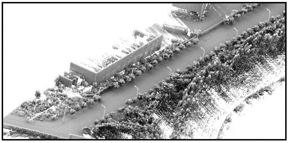
[0064] S1, for the obtained entire three-dimensional point cloud data set P, screen the seed points to perform super-voxel division (the original point cloud data of the present embodiment can be seen figure 2 );

[0065] Supervoxel division refers to gathering adjacent points with the same properties into a super point to reduce the complexity of data processing;

[0066] S11. Solve the fitting plane T p (p i ):

[0067] For each input point p of the entire 3D point cloud dataset P i , its tangent plane Tp(p i ) can be represented by its center point o i and the normal vector n l composed of two-tuples, namely

[0068]

[0069] From any point p to Tp in three-dimensional space (p i ) can be expressed as

[0070]...


PUM


Abstract

The invention relates to the field of point cloud processing, and specifically discloses a three-dimensional point cloud road boundary automatic extraction method. The method comprises the steps of S1, screening seed points for the whole acquired three-dimensional point cloud data set P so as to perform super voxel classification; S2, extracting boundary points between adjacent non-coplanar super voxels by using an alpha-shape algorithm; S3, extracting road boundary points by using a graph cut based energy minimization algorithm; S4, removing outliers based on an Euclidean distance clustering algorithm; and S5, fitting the extracted road boundary points into a smooth curve. The method can directly operate on the large-scale three-dimensional point cloud, can be applied to different scenes, is high in calculation speed and good in algorithm robustness, and can extract road boundaries quickly.

Description

technical field [0001] The invention relates to the field of point cloud processing, in particular to a method for automatically extracting road boundaries from three-dimensional point clouds. Background technique [0002] As a transportation infrastructure, the digital management and construction of roads is of great significance for applications such as urban planning, traffic management, and navigation. As a rapidly developing high-tech surveying and mapping technology, vehicle-mounted laser scanning technology has the advantages of fast data acquisition speed, high data accuracy, non-contact active measurement, and strong real-time performance compared with traditional surveying and mapping methods. Obtaining detailed three-dimensional spatial information of roads and features on both sides has obvious advantages for obtaining road information in strip distribution. [0003] Traditional methods of obtaining road information mainly include manual measurement and digital ...

Claims


Application Information

Patent Timeline
Patent Type & Authority Applications(China)
IPC IPC(8): G06T7/13
CPCG06T2207/10028G06T2207/30256
Inventor 李军宰大卫林阳斌郭裕兰王程
Owner XIAMEN UNIV
Why Eureka
Try Eureka