Single camera ground target point spatial positioning method based on digital elevation map

A digital elevation and spatial positioning technology, which is applied in the field of spatial positioning measurement of ground target points and single-camera measurement, which can solve the problems of spatial positioning of difficult target points and difficulty in extracting auxiliary feature points.

Inactive Publication Date: 2017-06-06
TIANJIN UNIV
View PDF5 Cites 2 Cited by
  • Summary
  • Abstract
  • Description
  • Claims
  • Application Information

AI Technical Summary

Problems solved by technology

[0003] Compared with the multi-camera measurement system, the single-camera visual measurement system has a simple structure and a large measurement field of view, which avoids problems such as feature point matching in real-time measurement. However, the current monocular measurement needs to extract auxiliary feature points to complete a single frame. The spatial coordinates of the target points in the image are calculated. When the camera monitors random ground targets in a large area, it is impossible or difficult to extract the auxiliary feature points available for the solution. That is, it is difficult to effectively measure the space of the target points with the current single-camera measurement method. position

Method used


Image

  • Single camera ground target point spatial positioning method based on digital elevation map
  • Single camera ground target point spatial positioning method based on digital elevation map
  • Single camera ground target point spatial positioning method based on digital elevation map

Examples


Embodiment Construction

[0011] A digital elevation map-based single-camera ground target point positioning method of the present invention will be described below in conjunction with the embodiments and accompanying drawings. Give detailed instructions.

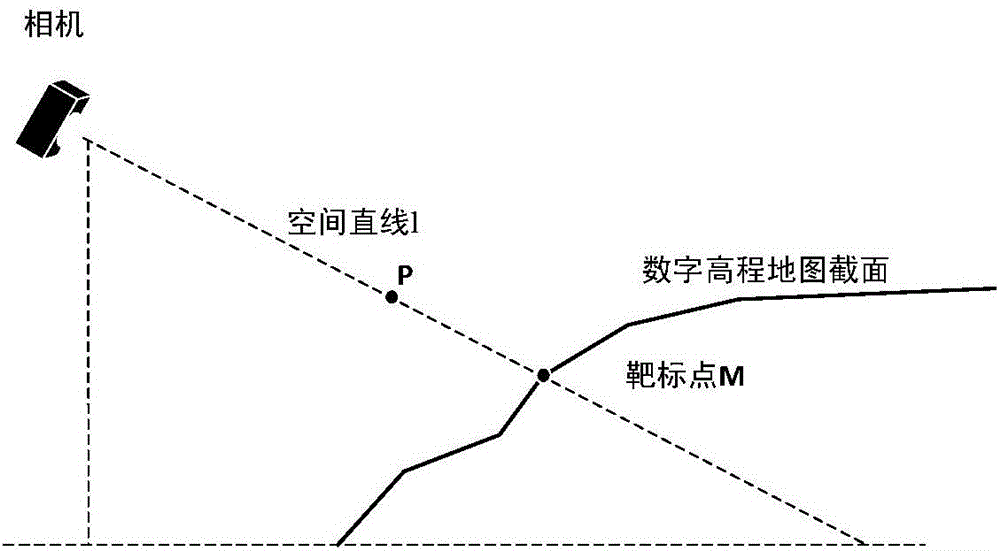
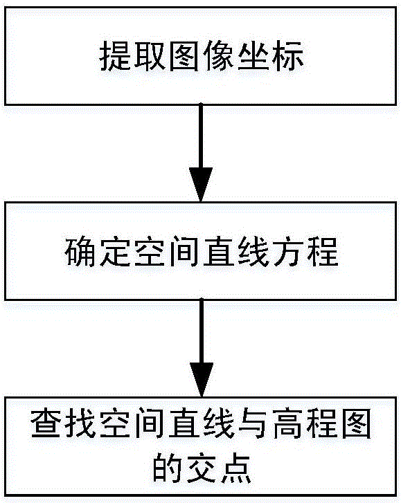
[0012] The invention proposes a method for positioning and measuring ground target points by using a single camera in combination with a digital elevation map, collects target point images in real time with a single camera, and calculates the spatial coordinates of the target points in real time. Using the image coordinates of the target point, according to the camera imaging model, the spatial target point and the imaging line equation determined by the optical center of the camera can be obtained in real time, and the spatial coordinates of the target point can be obtained by finding the effective intersection point of the space line equation and the digital elevation map.

[0013] The specific design is as follows:

[0014] Such as figure 1 Sho...


PUM


Abstract

The invention relates to a single camera ground target point spatial positioning method based on a digital elevation map. The method comprises the following steps: obtaining a single camera parameter and establishing a spatial coordinate system; setting a single camera position as (XC, YC, ZC), using a single camera to acquire the image coordinate m (u, v) of a ground target point M (X1, Y1, Z1), and determining a spatial imaging line L from a known image coordinate; defining a nearest intersection to the single camera as an effective intersection because there may be multiple intersections between the spatial imaging line L and the digital elevation map, traversing the digital elevation map according to the projection of the spatial imaging line L in the X-Y plane in the spatial coordinate system, determining the position of the effective intersection by comparing the height difference between the digital elevation map and the corresponding point on the spatial imaging line L so as to obtain the spatial coordinate of the ground target point. The method may position the ground target point without auxiliary feature points except the target point.

Description

technical field [0001] The invention relates to the fields of single-camera measurement and space positioning measurement of ground target points. Background technique [0002] Visual positioning measurement technology is more and more widely used in aerospace, industry, military industry and other fields. At present, it is mainly divided into monocular visual measurement, multi-eye (including binocular) visual measurement, etc. Among them, multi-eye visual measurement uses multi-camera At the same time, the image of the target is collected and the spatial coordinates of the target are determined according to the relative positional relationship between the cameras. Due to the limitation that a single camera cannot obtain the target depth direction information, two methods based on cooperative targets and non-cooperative targets are mostly used in monocular vision measurement, including the solution of typical PNP problems in monocular measurement. The known auxiliary featur...

Claims


Application Information

Patent Timeline
Patent Type & Authority Applications(China)
IPC IPC(8): G01B11/00
CPCG01B11/002
Inventor 王向军刘峰邓子贤曹雨
Owner TIANJIN UNIV
Why Eureka
Try Eureka