Local area positioning method and system

A technology of local area and positioning method, applied in the field of positioning and navigation, which can solve problems such as inability to locate

Inactive Publication Date: 2017-06-06
纵横壹旅游科技(成都)有限公司
View PDF5 Cites 1 Cited by
  • Summary
  • Abstract
  • Description
  • Claims
  • Application Information

AI Technical Summary

Problems solved by technology

[0003] The technical problem to be solved by the present invention is to provide a local area positioning method and system, which can lock the target local area through deployed sensors, and calculate the actual position in

Method used


Image

  • Local area positioning method and system
  • Local area positioning method and system

Examples


Embodiment Construction

[0034] The principles and features of the present invention are described below in conjunction with the accompanying drawings, and the examples given are only used to explain the present invention, and are not intended to limit the scope of the present invention.

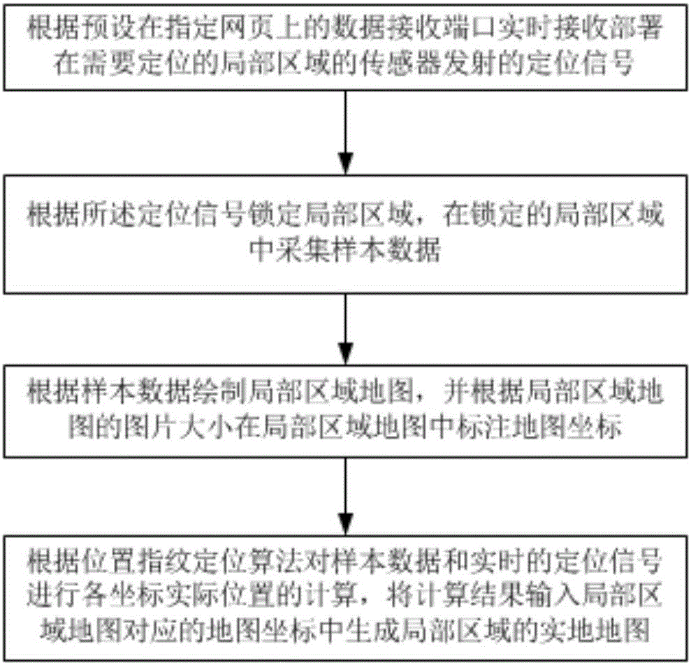
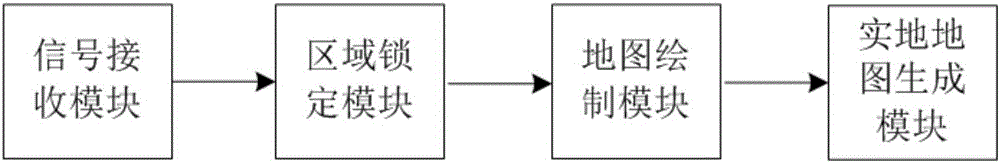
[0035] figure 1 The method flow chart of the local area positioning method embodiment provided by the embodiment of the present invention;

[0036] Such as figure 1 As shown, a local area positioning method includes the following steps:

[0037] Step S1: according to the preset data receiving port on the specified webpage, receive the positioning signal emitted by the sensor deployed in the local area to be positioned in real time;

[0038] Step S2: Lock a local area according to the positioning signal, and collect sample data in the locked local area;

[0039] Step S3: Draw a local area map according to the sample data, and mark the map coordinates in the local area map according to the image size of the local a...


PUM


Abstract

The invention relates to a local area positioning method and system. The method comprises the steps of: receiving a positioning signal transmitted by a sensor deployed in a local area to be positioned according to a data receiving port preset on a designated webpage; locking the local area according to the positioning signal and acquiring sample data in the locked local area; drawing a local area map based on the sample data, and marking map coordinates in the local area map according to the image size of the local area map; according to a position fingerprint positioning algorithm, calculating the actual positions of various coordinates for the sample data and positioning signals, inputting a calculation result into the map coordinates corresponding to the local area map to generate an actual map of the local area. The method and system can lock the target local area through the deployed sensor, and calculate the actual position in the drawn local area map to obtain the actual map of the local area, and solve positioning incapability in the local area environment where the satellite and other positioning signals cannot be received.

Description

technical field [0001] The invention relates to the field of positioning and navigation, in particular to a local area positioning method and system. Background technique [0002] Satellites and other external signals cannot be received in the environment of some local areas, so some current mainstream maps cannot generate electronic maps for this local area, cannot determine the current location, and cannot perform positioning and navigation for this local area. Contents of the invention [0003] The technical problem to be solved by the present invention is to provide a local area positioning method and system, which can lock the target local area through deployed sensors, and calculate the actual position in the drawn local area map, thereby generating a local area on-the-spot map, solving Solved the problem of inability to locate in the environment of local areas where satellites and other positioning signals cannot be received. [0004] The technical solution of the ...

Claims


Application Information

Patent Timeline
IPC IPC(8): G01S11/02
CPCG01S11/02
Inventor 张成才
Owner 纵横壹旅游科技(成都)有限公司
Why Eureka
Try Eureka