Ground microseismic event locating method based on Fresnel volume tomography inversion
A technology of tomographic inversion and positioning method, which is applied in the field of geophysical exploration, can solve the problems of large positioning errors, achieve the effects of reducing positioning errors, optimizing computing efficiency, and improving positioning accuracy
- Summary
- Abstract
- Description
- Claims
- Application Information
AI Technical Summary
Problems solved by technology
Method used
Image
Examples
Embodiment 1
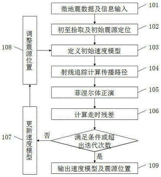
[0051] Example 1. Such as figure 1 As shown, the ground microseismic event location method based on Fresnel volume tomography includes the following steps: (1) microseismic data and information input; (2) first arrival picking and initial source location; (3) defining the initial velocity (4) Ray tracing to calculate propagation path; (5) Fresnel body forward modeling; (6) Calculate travel time residual; (7) Solve tomographic inversion equation to calculate velocity correction; (8) Update velocity model and Source location; (9) Replace the velocity model in step (3) with the velocity model in step (8), repeat steps (3)-(8), and output the final velocity model and source location.
[0052] The current mainstream microseismic event location methods include longitudinal and transverse wave time difference method, homotype wave time difference method, Monte Carlo method and energy scanning superposition method, etc. These methods all use constant equivalent velocity as the veloci...
PUM
 Abstract
Description
Claims
Application Information
 - R&D
- Intellectual Property
- Life Sciences
- Materials
- Tech Scout
- Unparalleled Data Quality
- Higher Quality Content
- 60% Fewer Hallucinations
Browse by: Latest US Patents, China's latest patents, Technical Efficacy Thesaurus, Application Domain, Technology Topic, Popular Technical Reports.
© 2025 PatSnap. All rights reserved.Legal|Privacy policy|Modern Slavery Act Transparency Statement|Sitemap|About US| Contact US: help@patsnap.com


