Soil moisture status monitoring method and system

A soil moisture and unmanned aerial vehicle technology, applied in the field of agricultural information, can solve problems such as large sampling errors, difficult scientific irrigation of farmland, and inability to know the distribution of farmland soil moisture

Inactive Publication Date: 2017-06-20
河北天遥航空设备科技有限公司
View PDF5 Cites 7 Cited by
  • Summary
  • Abstract
  • Description
  • Claims
  • Application Information

AI Technical Summary

Problems solved by technology

Traditional observation methods include soil sampling and drying method, neutron moisture meter method, tensiometer method, etc., all of which are measured at points, and there are large sampling errors, and it is impossible to know the distribution of soil moisture in large areas of farmland. Auxiliary realization of scientific irrigation of farmland

Method used


Image

  • Soil moisture status monitoring method and system
  • Soil moisture status monitoring method and system
  • Soil moisture status monitoring method and system

Examples


Embodiment 1

[0026] Based on the above principles, the present embodiment provides a soil moisture monitoring method, comprising the following steps:

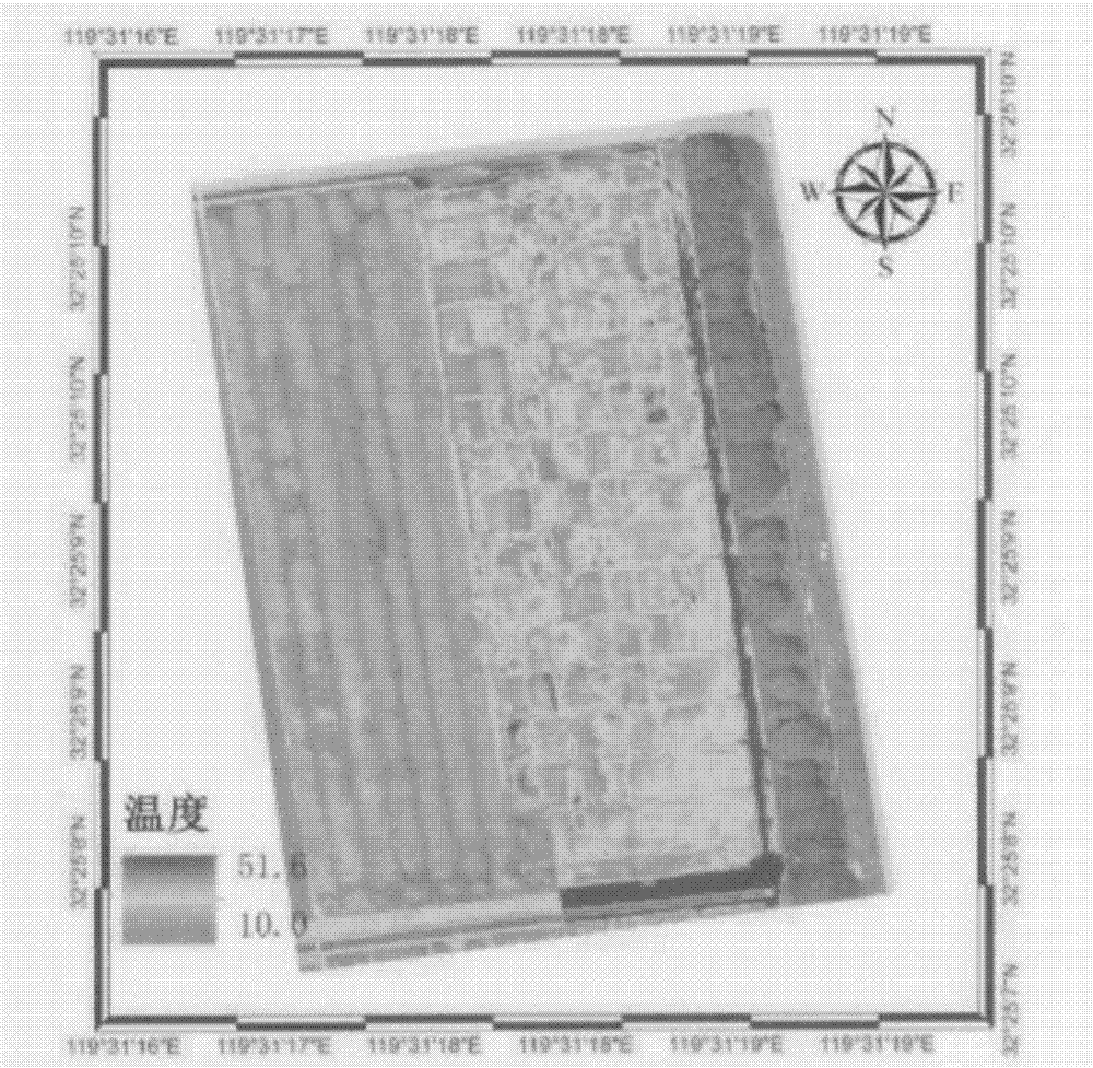
[0027] 1) The thermal infrared camera system and GPS module installed on the UAV flight device preset the route and photo time;

[0028] 2) The UAV flies according to the predetermined route, and the thermal infrared camera takes pictures according to the preset time, monitors the weather information, and stores the location information of the UAV's flight route, photos and weather information;

[0029] 3) Comparing and analyzing flight route location information, photo information and meteorological information to obtain soil moisture information.

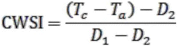
[0030] The comparative analysis in the step 3) is calculated using the following formula:

[0031]

[0032] CWSI is the crop water stress index, Tc is the crop canopy temperature, Ta is the air temperature, D1 is the maximum temperature difference between the canopy and the air (generally t...

Embodiment 2

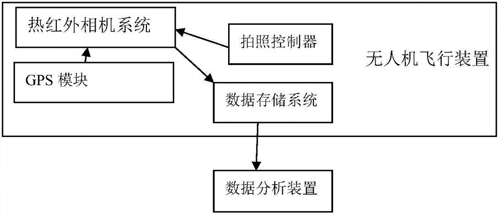
[0041] 6. The present invention also provides a soil moisture monitoring system, including a thermal infrared camera system, a GPS module, a camera controller, a data storage system, a data analysis device and an unmanned aerial vehicle flying device, wherein the camera controller, thermal infrared camera The system and the GPS module are installed on the unmanned aerial vehicle flight device; the camera controller is connected with the thermal infrared camera system through a data link; the thermal infrared camera system is connected with the GPS module and the data storage device respectively; the data storage device Connect with data analysis device.

[0042] Further, the camera controller, thermal infrared camera system and GPS module are installed on the UAV flight device through a platform with shock-absorbing accessories.

[0043] Further, the data analysis device is an electronic device with data processing capabilities, such as a computer.

[0044] Further, the drone...


PUM


Abstract

The invention provides a soil moisture status monitoring method and system, and belongs to the technical field of agricultural information. The system comprises an infrared camera system, a GPS module, a photographing controller, a data storage system, a data analysis device and an unmanned plane flight device, wherein the photographing controller, the infrared camera system and the GPS module are installed on the unmanned plane flight device. The photographing controller is connected with the infrared camera system and the GPS module through a data link. The photographing controller is connected with a ground control device and the data storage device. The data storage device is connected with the data analysis device. The method and system can formulate a scientific irrigation scheme and provide a scientific basis.

Description

technical field [0001] The invention relates to the technical field of agricultural information, in particular to a soil moisture monitoring method and system. Background technique [0002] Scientific irrigation is an important part of agricultural water saving. The establishment of a reasonable irrigation plan is the premise of scientific irrigation, and the diagnosis of crop water shortage is the basis for formulating a reasonable irrigation plan. The monitoring of soil moisture status has always been valued by people, especially with the aggravation of water shortage. Traditional observation methods include soil sampling and drying method, neutron moisture meter method, tensiometer method, etc., all of which are measured at points, and there are large sampling errors, and it is impossible to know the distribution of soil moisture in large areas of farmland. Assist in the scientific irrigation of farmland. Contents of the invention [0003] In order to solve the proble...

Claims


Application Information

Patent Timeline
Patent Type & Authority Applications(China)
IPC IPC(8): G01J5/00G01S19/38G01W1/02
CPCG01J5/00G01J2005/0077G01S19/38G01W1/02
Inventor 李红军刘立秋杨帆马亚民李磊
Owner 河北天遥航空设备科技有限公司
Why Eureka
Try Eureka