GPS data validity determination method and device

A GPS data and validity technology, which is applied in the field of satellite navigation, can solve problems such as GPS analysis errors, normal positioning satellite numbers, and incorrect judgments of GPS data validity, and achieve comprehensive analysis and detection and improve reliability.

Inactive Publication Date: 2017-07-04
BEIJING JINGDONG SHANGKE INFORMATION TECH CO LTD +1
View PDF6 Cites 15 Cited by
  • Summary
  • Abstract
  • Description
  • Claims
  • Application Information

AI Technical Summary

Problems solved by technology

However, in practical applications, it often occurs that the number of positioning stars is normal but the GPS resolves the problem incorrectly.
Therefore, this unreliable judgment method will cause the flight control to make mistakes in judging the validity of GPS data, thereby affecting the accuracy of the flight control system

Method used


Image

  • GPS data validity determination method and device
  • GPS data validity determination method and device
  • GPS data validity determination method and device

Examples


Embodiment Construction

[0029] Various exemplary embodiments of the present invention will now be described in detail with reference to the accompanying drawings. It should be noted that the relative arrangements of components and steps, numerical expressions and numerical values ​​set forth in these embodiments do not limit the scope of the present invention unless specifically stated otherwise.

[0030] At the same time, it should be understood that, for the convenience of description, the sizes of the various parts shown in the drawings are not drawn according to the actual proportional relationship.

[0031] The following description of at least one exemplary embodiment is merely illustrative in nature and in no way taken as limiting the invention, its application or uses.

[0032] Techniques, methods and devices known to those of ordinary skill in the relevant art may not be discussed in detail, but where appropriate, such techniques, methods and devices should be considered part of the Authoriz...


PUM


Abstract

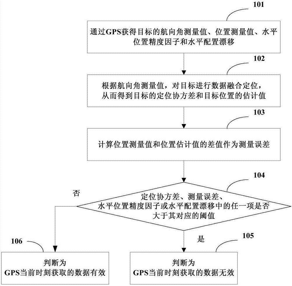
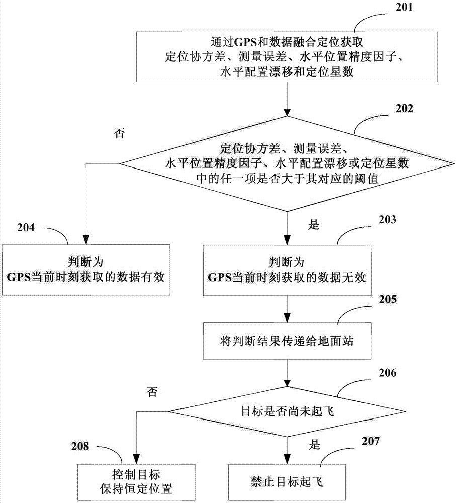
The present invention discloses a GPS data validity determination method and device, and relates to the satellite navigation technology field. The method comprises: obtaining course angle measured value, the position measured value, the horizontal position precision factor and the horizontal configuration drift of an object through a GPS; performing data fusion location of the object according to the course angle measured value so as to obtain the location covariance of the object and the estimated value of the object position; calculating the difference of the position measured value and the position estimated value as a measured error; and if any one of the location covariance, the measured error, the horizontal position precision factor or the horizontal configuration drift is larger than a corresponding threshold, determining that the data obtained at present is invalid through the GPS. The GPS data validity determination method and device can improve the determination reliability of the GPS data validity.

Description

technical field [0001] The present invention relates to the technical field of satellite navigation, in particular to a GPS (Global Positioning System, Global Positioning System) data validity judgment method and device. Background technique [0002] The existing flight control system often obtains the horizontal position information and speed information of the aircraft through GPS, so whether the data obtained by GPS is valid determines whether the aircraft has the ability to fly autonomously. In actual situations, due to the influence of cloudy, haze and other weather and the occlusion of buildings, the data acquired by GPS will often become invalid, thus affecting the accuracy of the flight control system. [0003] Most of the existing flight control systems only judge whether the GPS data is valid by judging the current GPS positioning satellite number. However, in practical applications, the problem that the number of positioning stars is normal but the GPS resolves e...

Claims


Application Information

Patent Timeline
IPC IPC(8): G01S19/42G01S19/37
CPCG01S19/37G01S19/42
Inventor 吴海超孙勇李大鹏历莹
Owner BEIJING JINGDONG SHANGKE INFORMATION TECH CO LTD
Why Eureka
Try Eureka