Automatic navigation method and device

A technology of automatic navigation and spatial location, which is applied in the field of computer vision, can solve the problems of high equipment cost, high requirements for transmitting equipment and receiving equipment, and increase the load of drones, so as to achieve optimal safety paths, solve the limitations of viewing angle and movement, The effect of high positioning accuracy

Active Publication Date: 2017-07-07
CHENGDU TOPPLUSVISION TECH CO LTD
View PDF5 Cites 40 Cited by
  • Summary
  • Abstract
  • Description
  • Claims
  • Application Information

AI Technical Summary

Problems solved by technology

[0004] Ultrasonic and infrared navigation and positioning technologies have the advantages of high resolution, but these technologies have relatively high requirements for transmitting equipment and receiving equipment, high equipment costs, and increase the load of drones and other products

Method used


Image

  • Automatic navigation method and device
  • Automatic navigation method and device
  • Automatic navigation method and device

Examples


Embodiment Construction

[0058]In order to enable those skilled in the art to better understand the solution of the present invention, the present invention will be further described in detail below in conjunction with the accompanying drawings and specific embodiments. Apparently, the described embodiments are only some of the embodiments of the present invention, but not all of them. Based on the embodiments of the present invention, all other embodiments obtained by persons of ordinary skill in the art without making creative efforts belong to the protection scope of the present invention.

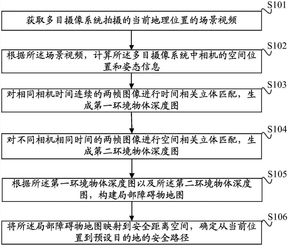
[0059] A flowchart of a specific implementation of the automatic navigation method provided by the present invention is as follows figure 1 As shown, the method includes:

[0060] Step S101: Obtain the scene video of the current geographical location captured by the multi-eye camera system;

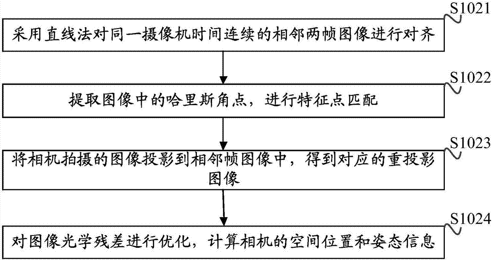
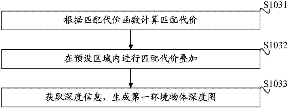
[0061] Step S102: Calculate the spatial position and attitude information of the cameras in the multi-eye camera syste...


PUM


Abstract

The invention discloses an automatic navigation method and device. The method comprises the following steps of: acquiring a scene video of a current geographical location photographed by a multi-objective camera system; calculating a spatial position and gesture information of the camera in the multi-objective camera system; performing time correlation three-dimensional matching on continuous two-frame images at the same camera time to generate a first environmental object depth map; performing spatial correlation three-dimensional matching on continuous two-frame images at different camera times to generate a second environmental object depth map; constructing a local obstacle map according to the first environmental object depth map and the second environmental object depth map; and mapping the local obstacle map to a safe distance space to determine a safety path from a current position to a predetermined target. The method effectively solves limitation of a conventional depth algorithm in viewing angel and movement, can perform self-position positioning, obstacle sensing and automatic generation of the safety path, is high in positioning precision and optimum in safety path, and can be applied to mobile platforms such as robots or entertainment unmanned aerial vehicle.

Description

technical field [0001] The invention relates to the technical field of computer vision, in particular to an automatic navigation method and device. Background technique [0002] With the rapid development of product technology such as drones, robots, and unmanned vehicles, the demand for navigation systems and methods has also increased significantly. Automatic navigation means that the moving body makes global path planning based on the known map information according to the predetermined task command, and constantly perceives the surrounding local environmental information, makes various decisions, and adjusts its own position at any time. Posture and position, guide yourself to move safely to the target position. Existing automatic navigation methods or systems mainly include two methods based on positioning and tracking technology. The automatic navigation method of positioning is relatively more intelligent, and there are many applications in the market, such as GPS, ...

Claims


Application Information

Patent Timeline
Patent Type & Authority Applications(China)
IPC IPC(8): G01C21/00
CPCG01C21/00
Inventor 陈美文周剑罗元泰
Owner CHENGDU TOPPLUSVISION TECH CO LTD
Why Eureka
Try Eureka