Extraction of elevation control points and its auxiliary positioning method for high-resolution image lidar

A technology of elevation control points and laser radar, which is applied in high-resolution remote sensing image photogrammetry, joint processing of multi-source remote sensing data, and data matching, can solve the problems of high-precision elevation accuracy and low density of laser height measurement

Active Publication Date: 2021-06-08
CHINESE ACAD OF SURVEYING & MAPPING
View PDF2 Cites 1 Cited by
  • Summary
  • Abstract
  • Description
  • Claims
  • Application Information

AI Technical Summary

Problems solved by technology

[0022] From the existing status, it can be seen that the DSM generated from stereo remote sensing images can obtain high ground resolution, but under the condition of no or few ground control points, the accuracy, especially the elevation accuracy, encounters a bottleneck problem
Although the height measurement laser radar has ideal elevation accuracy, the laser height measurement density is very low and cannot be directly used for DSM and DEM product generation.

Method used


Image

  • Extraction of elevation control points and its auxiliary positioning method for high-resolution image lidar
  • Extraction of elevation control points and its auxiliary positioning method for high-resolution image lidar
  • Extraction of elevation control points and its auxiliary positioning method for high-resolution image lidar

Examples


Embodiment Construction

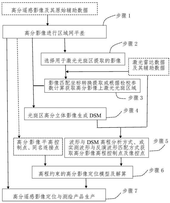
[0065] The invention utilizes the data of the laser altimeter sensor to assist in improving the ground positioning accuracy of the remote sensing image of the high-resolution sensor, especially the elevation accuracy. Positioning model, solving orientation parameters and encrypted points, improving the positioning accuracy of the image, especially the elevation accuracy. Specifically, it is realized through the following steps:

[0066] Step 1 uses conventional methods to perform block or free network adjustment on high-resolution remote sensing images in the survey area to obtain preliminary refined orientation parameters of each scene image, which are used as initial values ​​for image processing in subsequent steps 2 to 6.

[0067] Step 2 Select the high-resolution image for laser spot area extraction: select the high-resolution image obtained from the same platform of the altimetry lidar sensor at the same or similar time, and select the image that overlaps with the laser ...


PUM


Abstract

The invention provides a high-resolution image laser radar elevation control point extraction and its auxiliary positioning method, the core of which is to extract the high-resolution remote sensing image elevation control points and Its image control points, and by building a high-resolution image positioning model with elevation constraints, the accuracy of high-resolution image positioning can be improved. With the support of altimetry laser radar data, the invention can significantly improve the stereo positioning accuracy of high-resolution remote sensing images and the precision of high-resolution image surveying and mapping products.

Description

technical field [0001] The invention relates to the fields of high-resolution remote sensing image photogrammetry, data matching, joint processing of multi-source remote sensing data, etc., and in particular to a high-resolution image laser radar elevation control point in the field of joint processing of laser radar data and high-resolution remote sensing image data Extraction and its assisted positioning method. Background technique [0002] After decades of rapid development, satellite remote sensing data has formed from Landsat series (80m)-TM (30m)-SPOT1 / 2 / 4 (10m) to SPOT5HRS (10×5m)-SPOT5HRG (2.5m )-IKONOS (1.0m)-QuickBird (0.6m) with various resolutions, multi-temporal, high signal-to-noise ratio, high geometric and radiometric resolution (greater than 8 bits / pixel), global coverage of image sequences, for resource development , ecological environment protection and socio-economic planning to provide the necessary geospatial information. [0003] The geometric posit...

Claims


Application Information

Patent Timeline
Patent Type & Authority Patents(China)
IPC IPC(8): G06K9/00G01S17/86
CPCG01S17/86G06V20/13
Inventor 程春泉左志权黄国满张继贤张力
Owner CHINESE ACAD OF SURVEYING & MAPPING
Why Eureka
Try Eureka