Airborne LiDar-based golf navigation method

A navigation method, golf technology, applied in the field of navigation, can solve problems such as low accuracy of virtual data and complex calculation methods, and achieve the effect of improving accuracy and simple user interface

Active Publication Date: 2017-07-21
GUANGZHOU JIANTONG SURVEYING MAPPING & GEOINFORMATION TECH
View PDF7 Cites 0 Cited by
  • Summary
  • Abstract
  • Description
  • Claims
  • Application Information

AI Technical Summary

Problems solved by technology

[0004] In order to overcome the deficiencies of low accuracy of virtual data and complex calculation methods in existing golf navigation methods, the present invention provides a golf navigation method based on airborne LiDAR, comprising the following steps:

Method used


Image

  • Airborne LiDar-based golf navigation method
  • Airborne LiDar-based golf navigation method
  • Airborne LiDar-based golf navigation method

Examples


Embodiment Construction

[0052] In order to better understand the technical solution proposed by the present invention, the present invention will be further described below in conjunction with the accompanying drawings and specific embodiments.

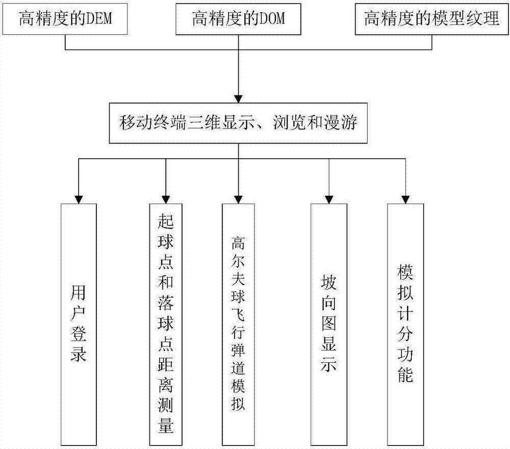
[0053] Such as figure 1 Shown, a kind of golf navigation method based on airborne LiDAR is characterized in that, comprises the steps:

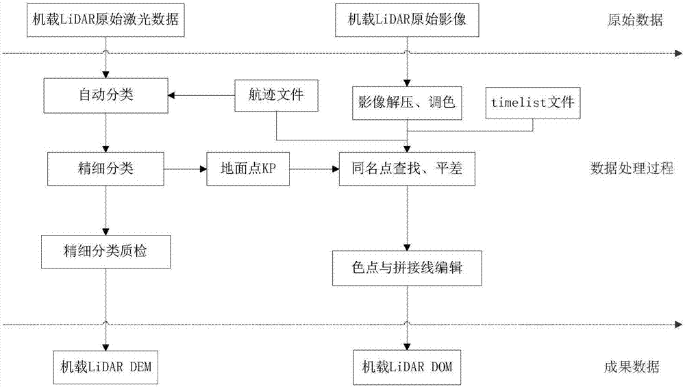
[0054] 1) Collect and process the 3D data of the golf course, and upload the processed data to the server;

[0055] 2) The terminal logs in, and can interact with the server after the verification is successful;

[0056] 3) The three-dimensional data of the golf course obtained by the terminal can browse all the holes of the golf course in real time, and observe the distance between the location and the hole;

[0057] 4) The terminal automatically measures the distance between the starting point and the landing point;

[0058] 5) Simulate the flight trajectory of golf ball;

[0059] 6) Swing strength estimation;

[0060]...


PUM


Abstract

The invention relates to an airborne LiDar-based golf navigation method. The method comprises the following steps that: 1) golf course three-dimensional data are collected and processed, and the processed data are uploaded to a server; 2) a terminal can log in and passes verification, and thereafter interacts with the server; 3) the terminal can browses all holes in a golf course and observes distances from a position where the user is located to the holes based on the obtained golf course three-dimensional data; 4) the terminal automatically measures a distance between a ball starting point and a ball falling point; 5) a golf ball flying trajectory is simulated; and 6) a club wielding force is estimated. The airborne LiDar-based golf navigation method of the invention has the advantages of high precision of simulation data and simple calculation method, and can improve the correctness of club selection and strategy responses.

Description

technical field [0001] The invention belongs to the technical field of navigation, and relates to an airborne LiDAR-based golf navigation method. Background technique [0002] CN 104931990 A A golf course navigation map surveying and mapping method, the surveying and mapping method is realized by a map surveying and mapping system, and the surveying and mapping system includes a base station receiver, at least one mobile station receiver and a radio station for data transmission; the surveying and mapping method includes: In the real-time dynamic RTK operation mode, some necessary data are input into the GPS control hand book, and the input data includes the coordinates, elevation, coordinate system conversion parameters, and leveling surface fitting parameters of the base station; the receiver of the base station is set up at a known point Above, the plane coordinates or elevation are known, and the point is located in the middle of the survey area; the receiver of the rove...

Claims


Application Information

Patent Timeline
Patent Type & Authority Applications(China)
IPC IPC(8): G01S17/89G01S19/49G06F17/30G06T17/05
CPCG01S17/89G01S19/49G06F16/29G06T17/05
Inventor 刘改进王师周晓翠王滋政杨喜源陈明强黄利飞吴锦期曾花朱文锋温桂连黄丽友黄彩义赵晨虹韦建宁
Owner GUANGZHOU JIANTONG SURVEYING MAPPING & GEOINFORMATION TECH
Why Eureka
Try Eureka