Navigation method and system based on complex terrains, computer equipment and medium

A navigation method and technology for complex terrain, applied in the field of the Internet of Things, can solve the problems of easy deviation of navigation information, weak GPS signal, and difficult to identify two-dimensional plane graphics, so as to improve convenience, solve inability to locate and get lost, and be widely used. Foreground effect

Pending Publication Date: 2022-01-21
BOE TECH GRP CO LTD
View PDF0 Cites 0 Cited by
  • Summary
  • Abstract
  • Description
  • Claims
  • Application Information

AI Technical Summary

Problems solved by technology

[0002] In complex terrain environments such as alleys, alleys or scenic spots with staggered terrain, users are easy to lose their direction, especially the two-dimensional plane graphics obtained by GPS positioning in traditional map

Method used


Image

  • Navigation method and system based on complex terrains, computer equipment and medium
  • Navigation method and system based on complex terrains, computer equipment and medium
  • Navigation method and system based on complex terrains, computer equipment and medium

Examples


Embodiment Construction

[0042] In order to illustrate the present invention more clearly, the present invention will be further described below in conjunction with preferred embodiments and accompanying drawings. Similar parts in the figures are denoted by the same reference numerals. Those skilled in the art should understand that the content specifically described below is illustrative rather than restrictive, and should not limit the protection scope of the present invention.

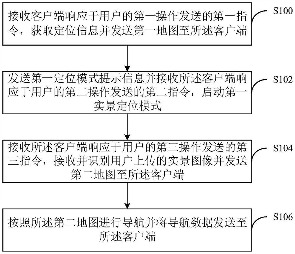
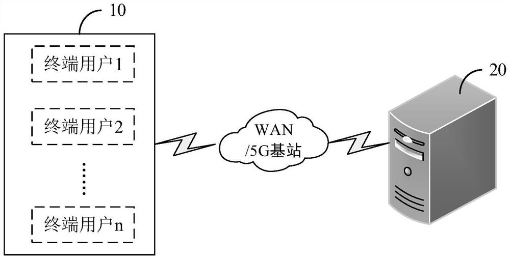
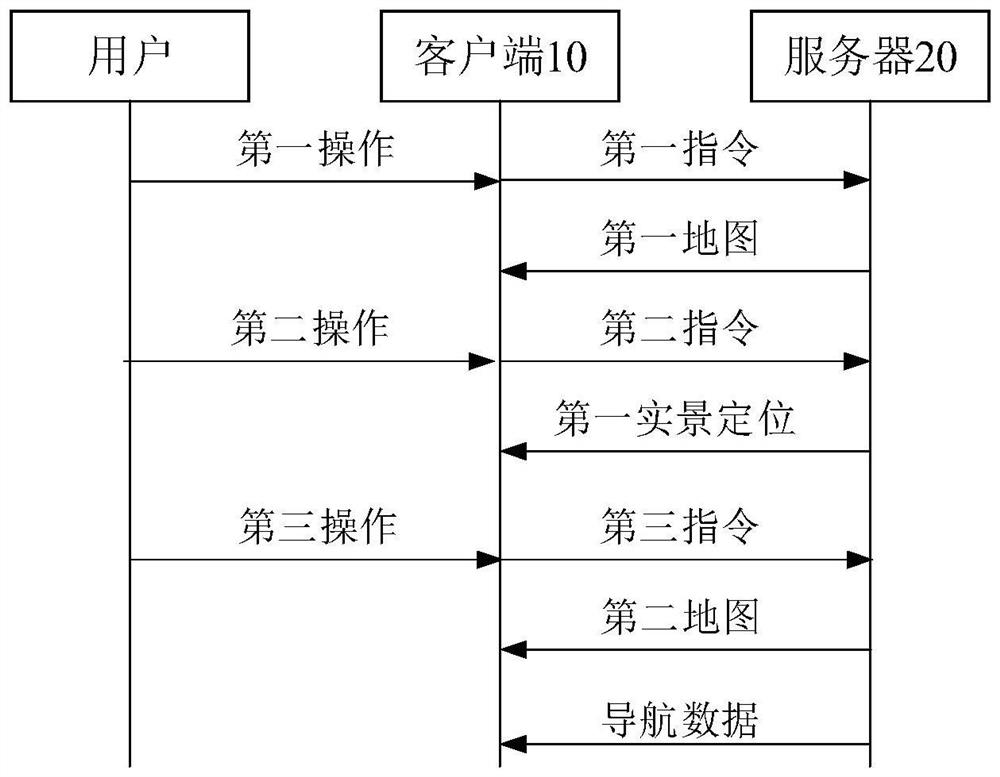
[0043] In complex terrain environments such as alleys or alleys or scenic spots with staggered terrain, users are easy to lose their direction, especially the traditional map navigation is a two-dimensional plane graphic obtained through GPS positioning, which is difficult to identify, especially in the field environment Complicated and when the GPS signal is weak, the navigation information is prone to deviation, and there is a problem that it cannot meet the navigation needs of users. To this end, an embodiment of the pr...


PUM


Abstract

The embodiment of the invention discloses a navigation method and system based on complex terrains, computer equipment and a medium. The navigation method comprises the following steps: receiving a first instruction sent by a client in response to a first operation of a user, acquiring positioning information and sending a first map to the client; sending first positioning mode prompt information and receiving a second instruction sent by the client in response to a second operation of the user, and starting a first live-action positioning mode; receiving a third instruction sent by the client in response to a third operation of the user, receiving and identifying a live-action image uploaded by the user, and sending a second map to the client; and navigating according to the second map and sending navigation data to the client. According to the invention, accurate positioning of the position of a user is realized in a mode of combining GPS positioning and live-action scanning, and the purpose of navigating the travel of the user is achieved by loading the three-dimensional live-action map of the position, so that the problem that the user cannot be positioned and is lost in a complex environment is solved.

Description

technical field [0001] The present invention relates to the technical field of the Internet of Things, in particular to a complex terrain-based navigation method, system, computer equipment and computer-readable storage medium. Background technique [0002] In complex terrain environments such as alleys, alleys or scenic spots with staggered terrain, users are easy to lose their direction, especially the two-dimensional plane graphics obtained by GPS positioning in traditional map navigation are difficult to identify, especially in complex on-site environments And when the GPS signal is weak, the navigation information is likely to deviate, and there is a problem that the navigation needs of the user cannot be met. Contents of the invention [0003] In order to solve at least one of the above problems, the present application proposes a navigation method, system, computer equipment and medium based on complex terrain. [0004] The first embodiment of the present invention...

Claims


Application Information

Patent Timeline
IPC IPC(8): G06F16/29G06F16/9537G06V20/10G06T17/05G01S19/42
CPCG06F16/29G06T17/05G06F16/9537G01S19/42
Inventor 陈乃川褚虓张哲
Owner BOE TECH GRP CO LTD
Why Eureka
Try Eureka